
Vilshofen an der Donau is a town in the German district of Passau.

Ottobrunn is a municipality southeast of Munich, Bavaria, Germany, founded in 1955. Ottobrunn consists of mainly semi-detached and detached houses, as well as extensive garden areas. Ottobrunn is also the German Headquarters of Airbus Defense and Space, with the majority of Airbus DS grounds situated in the neighbouring community of Taufkirchen. According to the Federal Statistical Office of Germany, the municipality is the second-most densely populated in all of Germany, trailing only Munich, and ahead of Berlin.
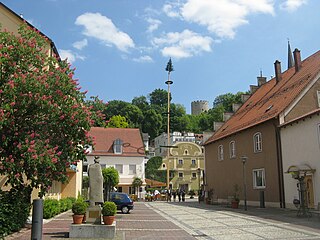
Bad Abbach is a municipality in the district Kelheim, Bavaria, Germany. Due to its sulphurous springs it has the status of a spa town.

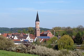
Mantel is a municipality located in the district of Neustadt an der Waldnaab in Bavaria, Germany. It is known as a Markt, a town that was historically granted 'market rights'. The town was first mentioned in official documents in 1212, and in 1945 it was incorporated into the municipality of Rupprechtsreuth. As part of the regional reform in Bavaria, parts of the dissolved municipality of Hütten were added to it in 1972. The town's population fell by 77 people, 2.8%, to 2728 between 1988 and 2018. Mantel is best known for its nature preserve, Naturwaldreservat Gscheibte Loh, as well as its castle, Schloss Steinfels.

Bruckmühl is a market town in the district of Rosenheim, in Bavaria, Germany. It is situated on the river Mangfall, 16 km west of Rosenheim.

Altdorf is a market town and municipality in the district of Landshut, in Bavaria, Germany. It is situated 4 km northwest of Landshut.

Berching is a town in the district of Neumarkt in Bavaria, Germany.

Rottenburg an der Laaber is a town in the district of Landshut, in Bavaria, Germany. It is situated on the river Große Laber, 21 km northwest of Landshut.
Rötz is a town in the district of Cham, in Bavaria, Germany. It is situated 17 km northwest of Cham, and 30 km east of Schwandorf.

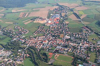
Schnaittenbach is a town in the Amberg-Sulzbach district, in Bavaria, Germany. It is situated 16 km northeast of Amberg.

Viechtach is a town in the district of Regen in Bavaria in Germany. It is situated on the river Schwarzer Regen, 31 km northeast of Straubing, and it is known for the quartz mountains nearby.
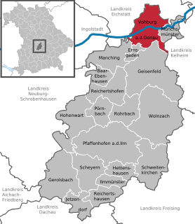
Vohburg is a town in the district of Pfaffenhofen, in Bavaria, Germany. It is situated on the right bank of the Danube, 14 km east of Ingolstadt.
Pfeffenhausen is a market town and a municipality in the district of Landshut in Bavaria in Germany.

Langdorf is a municipality in the district of Regen in Bavaria in Germany. It was formerly known as Dorfmuri.

Kallmünz is a municipality in the district of Regensburg in Bavaria, Germany. Situated at the river Naab about 25 km north of Regensburg Kallmünz has conserved a beautiful medieval center. The main attractions are the ruins of the Kallmünz Castle above the town on a cliff and the old stone bridge over the Naab River. It was in Kallmünz that the Russian painter Wassily Kandinsky and the German expressionist painter Gabriele Münter met during the summer of 1903. Since then Kallmünz has been the constant home to a small art colony.

Schwarzach is a market town and municipality in the district of Straubing-Bogen in Bavaria, Germany. It is the seat of the municipal association Schwarzach. The town is an officially recognised Resort town.

Pfaffenhausen is a municipality in the district of Unterallgäu in Bavaria, Germany. The town is seat of a municipal association with Breitenbrunn, Swabia, Oberrieden, Bavaria and Salgen.

Bad Endorf is a municipality in the district of Rosenheim in Bavaria in Germany. The relatively small town is located about 15 km outside of Rosenheim and is in close proximity to the Chiemsee lake and its larger shore towns, Prien, Gstadt, and Seebruck.

Hawangen is a municipality in the district of Unterallgäu in Bavaria, Germany, with about 1254 inhabitants. Hawangen is situated 5 km (3 mi) east of Memmingen. The town has a municipal association with Ottobeuren.

Stetten is a municipality in the district of Unterallgäu in Bavaria, Germany. The town has a municipal association with Dirlewang.


 Town center
 Town center
 Town hall


