Regen

Last updated

Regen
Regen, REG - B 85 - Regen v S 01.JPG
Regen
DEU Regen COA.svg
Coat of arms
Location of Regen within Regen district
Regen in REG.svg
Germany adm location map.svg
Red pog.svg
Regen
Bavaria location map.svg
Red pog.svg
Regen
Coordinates: 48°58′N13°8′E / 48.967°N 13.133°E / 48.967; 13.133 Coordinates: 48°58′N13°8′E / 48.967°N 13.133°E / 48.967; 13.133
Country Germany
State Bavaria
Admin. region Lower Bavaria
District Regen
Subdivisions59 districts
Government
   Mayor (202026) Andreas Kroner [1] (SPD)
Area
  Total65.15 km2 (25.15 sq mi)
Elevation
530 m (1,740 ft)
Population
 (2020-12-31) [2]
  Total10,888
  Density170/km2 (430/sq mi)
Time zone UTC+01:00 (CET)
  Summer (DST) UTC+02:00 (CEST)
Postal codes
94209
Dialling codes 09921
Vehicle registration REG
Website www.regen.de

Regen is a town in Bavaria, Germany, and the district town of the district of Regen.

Contents

Geography

Regen is situated on the great Regen River, located in the Bavarian Forest.

Divisions

Originally the town consisted of 4 districts: Bürgerholz, Grubhügel, Riedham and St. Johann.

After a governmental reform the villages of:

  • Aden
  • Augrub
  • Bärndorf
  • Bettmannsäge
  • Dreieck
  • Ebenhof
  • Ecklend
  • Edhof
  • Eggenried
  • Finkenried
  • Frauenmühle
  • Großseiboldsried
  • Huberhof
  • Kagerhof
  • Kattersdorf
  • Kerschlhöh
  • Kleinseiboldsried
  • Kreuzerhof
  • Kühhof
  • March
  • Maschenberg
  • Matzelsried
  • Metten
  • Neigerhöhe
  • Neigermühle
  • Neusohl
  • Obermitterdorf
  • Oberneumais
  • Oleumhütte
  • Pfistermühle
  • Pometsau
  • Poschetsried
  • Reinhartsmais
  • Richtplatz
  • Rinchnachmündt
  • Rohrbach
  • Sallitz
  • Schauerhof
  • Schlossau
  • Schochert
  • Schollenried
  • Schönhöh
  • Schützenhof
  • Schwaighof
  • Schweinhütt
  • Spitalhof
  • Sumpering
  • Tausendbach
  • Thanhof
  • Thurnhof
  • Weißenstein
  • Weißensteiner-Au
  • Wickersdorf
  • Wieshof and Windschnur

were added.

Population development

International relations

Regen is twinned with:

Notable places

The "Niederbayrisches Landwirtschaftsmuseum" is a museum showing the history of agriculture and society in Lower Bavaria from the 18th and 19th century.

The "Fressendes Haus" is a former domicile of the poets Clara Nordström (1886–1962) and Siegfried von Vegesack (1888–1974), which was transformed in a museum in 1984 presenting different expositions of historical art and the archeological excavations at the castle ruin of Weißenstein.

Natural monuments

Economy

Tourism figures largely in the local economy, with over 64,000 visitors accounting for 220,000 over-night stays last year.

Personalities

Related Research Articles

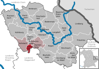
Regen is a Landkreis (district) in Bavaria, Germany. It is bounded by the districts of Freyung-Grafenau, Deggendorf, Straubing-Bogen and Cham, and by the Czech Republic.

Starnberg Place in Bavaria, Germany

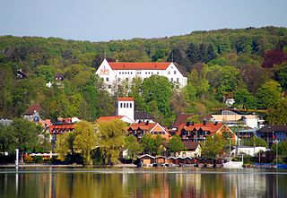
Starnberg is a German town in Bavaria, Germany, some 30 kilometres (19 mi) southwest of Munich. It is at the north end of Lake Starnberg, in the heart of the "Five Lakes Country", and serves as capital of the district of Starnberg. Recording a disposable per-capita income of €26,120 in 2007, Starnberg regained its status as the wealthiest town in Germany.

Wasserburg am Inn Place in Bavaria, Germany

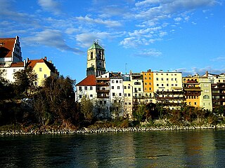
Wasserburg am Inn is a town in Rosenheim district in Upper Bavaria, Germany. The historic centre is a peninsula formed by the meandering river Inn. Many Medieval structures remain intact, giving the city a unique view.

Roth, Bavaria Place in Bavaria, Germany

Roth is a town in Bavaria, Germany, the capital of the Roth District. It is located about 25 km south of Nuremberg.

Viechtach Place in Bavaria, Germany

Viechtach is a town in the district of Regen in Bavaria in Germany. It is situated on the river Schwarzer Regen, 31 km northeast of Straubing, and it is known for the quartz mountains nearby.

Achslach Place in Bavaria, Germany

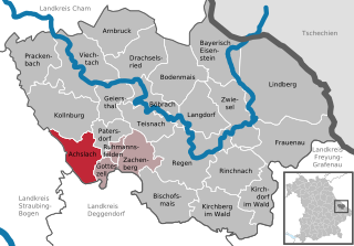
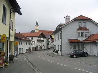
Achslach is a municipality in the district of Regen in Bavaria in Germany.

Arnbruck Place in Bavaria, Germany

Arnbruck is a municipality in the district of Regen, in Bavaria, Germany.

Bischofsmais Place in Bavaria, Germany

Bischofsmais is a municipality in the district of Regen, in Bavaria, Germany. It is well known for winter sports, especially cross-country skiing.

Böbrach Place in Bavaria, Germany

Böbrach is a municipality in the district of Regen, in Bavaria, Germany.

Bodenmais Place in Bavaria, Germany

Bodenmais is a municipality in the district of Regen in Bavaria in Germany. It lies at one end of the Zeller Valley in the Bavarian Forest.

Frauenau Place in Bavaria, Germany

Frauenau is a municipality in the district of Regen, in Bavaria, Germany. It is known for its artificial lake, which is used as a water supply of the area around Deggendorf and Passau.

Geiersthal Place in Bavaria, Germany

Geiersthal is a municipality in the district of Regen in Bavaria in Germany.

Gotteszell Place in Bavaria, Germany

Gotteszell is a municipality in the district of Regen in Bavaria in Germany.

Kirchberg im Wald Place in Bavaria, Germany

Kirchberg im Wald is a municipality in the district of Regen, in Bavaria, Germany.

Kollnburg Place in Bavaria, Germany

Kollnburg is a municipality in the district of Regen, in Bavaria, Germany.

Langdorf Place in Bavaria, Germany

Langdorf is a municipality in the district of Regen in Bavaria in Germany. It was formerly known as Dorfmuri.

Ruhmannsfelden Place in Bavaria, Germany

Ruhmannsfelden is a larger municipality in the district of Regen, in Bavaria, Germany.

Zachenberg Place in Bavaria, Germany

Zachenberg is a municipality in the district of Regen in Bavaria in Germany.

Lindberg Place in Bavaria, Germany

Lindberg is a municipality in the district of Regen in Bavaria in Germany in the immediate neighbourhood of the larger town Zwiesel.

Kirchdorf im Wald Place in Bavaria, Germany

Kirchdorf im Wald is a municipality in the district of Regen in Bavaria in Germany.

References

  1. Liste der ersten Bürgermeister/Oberbürgermeister in kreisangehörigen Gemeinden, Bayerisches Landesamt für Statistik, 15 July 2021.
  2. "Tabellenblatt "Daten 2", Statistischer Bericht A1200C 202041 Einwohnerzahlen der Gemeinden, Kreise und Regierungsbezirke". Bayerisches Landesamt für Statistik und Datenverarbeitung (in German). June 2021.