
An airport is an aerodrome with extended facilities, mostly for commercial air transport. They usually consist of a landing area, which comprises an aerially accessible open space including at least one operationally active surface such as a runway for a plane to take off and to land or a helipad, and often includes adjacent utility buildings such as control towers, hangars and terminals, to maintain and monitor aircraft. Larger airports may have airport aprons, taxiway bridges, air traffic control centres, passenger facilities such as restaurants and lounges, and emergency services. In some countries, the US in particular, airports also typically have one or more fixed-base operators, serving general aviation.

Air traffic control (ATC) is a service provided by ground-based air traffic controllers who direct aircraft on the ground and through a given section of controlled airspace, and can provide advisory services to aircraft in non-controlled airspace. The primary purpose of ATC is to prevent collisions, organise and expedite the flow of traffic in the air, and provide information and other support for pilots.

According to the International Civil Aviation Organization (ICAO), a runway is a "defined rectangular area on a land aerodrome prepared for the landing and takeoff of aircraft". Runways may be a human-made surface or a natural surface. Runways, taxiways and ramps, are sometimes referred to as "tarmac", though very few runways are built using tarmac. Takeoff and landing areas defined on the surface of water for seaplanes are generally referred to as waterways. Runway lengths are now commonly given in meters worldwide, except in North America where feet are commonly used.

In aviation, the instrument landing system (ILS) is a precision radio navigation system that provides short-range guidance to aircraft to allow them to approach a runway at night or in bad weather. In its original form, it allows an aircraft to approach until it is 200 feet (61 m) over the ground, within a 1⁄2 mile (800 m) of the runway. At that point the runway should be visible to the pilot; if it is not, they perform a missed approach. Bringing the aircraft this close to the runway dramatically increases the range of weather conditions in which a safe landing can be made. Other versions of the system, or "categories", have further reduced the minimum altitudes, runway visual ranges (RVRs), and transmitter and monitoring configurations designed depending on the normal expected weather patterns and airport safety requirements.

A taxiway is a path for aircraft at an airport connecting runways with aprons, hangars, terminals and other facilities. They mostly have a hard surface such as asphalt or concrete, although smaller general aviation airports sometimes use gravel or grass.

Laughlin/Bullhead International Airport is a public use airport located 1.15 miles north of the central business district of Bullhead City, in Mohave County, Arizona, United States. It is owned by Mohave County. The airport is across the Colorado River and one block away from Laughlin, Nevada. Many of the rooms at Laughlin's casino-hotels offer a view of the airport. It was named 2011 Airport of the Year by the Arizona Department of Transportation.

A precision approach path indicator (PAPI) is a system of lights on the side of an airport runway threshold that provides visual descent guidance information during final approach. It is generally located on the left-hand side of the runway approximately 300 metres (980 ft) beyond the landing threshold of the runway.

On the evening of February 1, 1991, USAir Flight 1493, a Boeing 737-300, collided with SkyWest Airlines Flight 5569, a Fairchild Swearingen Metroliner turboprop aircraft, upon landing at Los Angeles International Airport (LAX). As Flight 1493 was on final approach, the local controller was distracted, though air traffic was not heavy at LAX, by a series of abnormalities, including a misplaced flight progress strip and an aircraft that had inadvertently switched off the tower frequency. The SkyWest flight was told to taxi into takeoff position, while the USAir flight was landing on the same runway.
A NOTAM is a notice filed with an aviation authority to alert aircraft pilots of potential hazards along a flight route or at a location that could affect the flight. NOTAMs are notices or advisories that contain information concerning the establishment, conditions or change in any aeronautical facility, service, procedure or hazard, the timely knowledge of which may be essential to personnel and systems concerned with flight operations.

Comair Flight 5191 was a scheduled United States domestic passenger flight from Lexington, Kentucky, to Atlanta, Georgia. On the morning of August 27, 2006, at around 06:07 EDT, the Bombardier Canadair Regional Jet 100ER crashed while attempting to take off from Blue Grass Airport in Fayette County, Kentucky, 4 miles west of the central business district of the city of Lexington.

Lebanon-Warren County Airport is a public airport located three miles (5 km) northwest of the central business district of Lebanon, on Greentree Road, in Warren County, Ohio, United States.

A runway incursion is an aviation incident involving improper positioning of vehicles or people on any airport runway or its protected area. When an incursion involves an active runway being used by arriving or departing aircraft, the potential for a collision hazard or instrument landing system (ILS) interference can exist. At present, various runway safety technologies and processes are commonly employed to reduce the risk and potential consequences of such an event.

The 2007 San Francisco International Airport runway incursion occurred around 1:36 p.m. PDT on May 26, 2007, when SkyWest Airlines Flight 5741, an Embraer EMB 120 Brasilia turboprop aircraft, nearly collided with Republic Airways Flight 4912, an Embraer 170 Regional Jet, at the intersection of Runways 1L and 28R at San Francisco International Airport (SFO).

Brandywine Airport is a public-use general aviation airport in West Goshen Township, Pennsylvania, United States, three miles northeast of West Chester. It is designated as a reliever airport and a regional general aviation airport by the FAA. It is privately owned by the New Brandywine Airport Club Inc, with a single fixed-base operator, aircraft repair, as well as flight training in both fixed-wing and rotary aircraft. The American Helicopter Museum and Education Center is located adjacent to the airport, with taxiway access.

The Spartanburg Downtown Memorial Airport is a general aviation airport located in the city of Spartanburg, South Carolina. The airport is 3 miles (4.8 km) from downtown Spartanburg, which makes it popular for private and corporate aircraft.
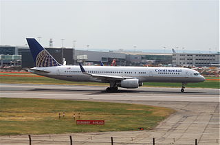
Continental Airlines Flight 1883 was a Boeing 757 that mistakenly landed on a taxiway at Newark Liberty International Airport on the evening of October 28, 2006. There were no reported injuries or damage, but the narrowly averted disaster was investigated by the National Transportation Safety Board, and caused the Federal Aviation Administration to reevaluate and modify air and ground safety procedures at and around Newark Airport.
Runway safety is concerned with reducing harm that could occur on an aircraft runway. Safety means avoiding incorrect presence (incursion) of aircraft, inappropriate exits (excursion) and use of the wrong runway due to confusion. The runway condition is a runway's current status due to meteorological conditions and air safety.

On July 7, 2017, an Airbus A320-211 operating as Air Canada Flight 759 was nearly involved in an accident at San Francisco International Airport in San Mateo County, California, United States. The flight, which originated at Toronto Pearson International Airport, had been cleared by air traffic control to land on runway 28R and was on final approach to land on that runway; however, instead of lining up with the runway, the aircraft had lined up with the parallel taxiway, on which four fully loaded and fueled passenger airplanes were stopped awaiting takeoff clearance. The flight crew initiated a go-around prior to landing, after which it landed on 28R without further incident. The aircraft on the taxiway departed for their intended destinations without further incident. The subsequent investigation by the National Transportation Safety Board (NTSB) determined that the Air Canada airplane descended to 59 feet (18 m) above the ground before it began its climb, and that it missed colliding with one of the aircraft on the taxiway by 14 feet (4.3 m).
Airport surveillance and broadcast systems are a set of runway-safety tools that display aircraft on and near an airport.

Iberia Flight 933 was an international flight from Madrid Barajas International Airport bound for its destination, Boston-Logan International Airport in Boston that suffered a crash landing on December 17, 1973. As the McDonnell Douglas DC-10 operating the flight was approaching the airport, it collided with the approach lighting system (ALS) 500 feet (152 m) short of the runway threshold. The impact broke off the right main landing gear. The aircraft became airborne for about 1,200 feet (370 m), then landed on runway 33 Left, veered to the right off the runway and came to rest. All 168 on board survived, but the plane was written off. This accident was the first hull loss of the DC-10.


