 Rupert's Bay Church
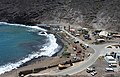 Rupert's Wharf
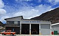 Sea Rescue Service
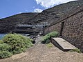 Rupert harbour
Ruperts | |
|---|---|
Village | |
 View of Rupert's Bay | |
 Location on Saint Helena | |
| Coordinates: 15°55′10.9″S5°42′44.0″W / 15.919694°S 5.712222°W | |
| Sovereign state | United Kingdom |
| British overseas territory | |
| Island | |
| District | Jamestown |
| Time zone | UTC+0 (GMT) |
| Area code | +44 |
Ruperts, also written as Rupert's, is a village in the island of Saint Helena, in Saint Helena, Ascension and Tristan da Cunha, an overseas territory of the in the South Atlantic Ocean. It is a waterfront settlement located within the island's Jamestown district. It features a valley settlement with infrastructure including a major commercial port, power station, and fuel installations.


