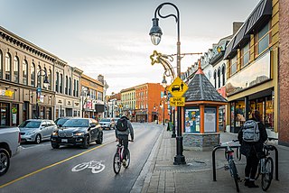
St. Catharines is the most populous city in Canada's Niagara Region, the eighth largest urban area in the province of Ontario. As of 2017, St. Catharines has an area of 96.13 square kilometres (37.12 sq mi) and 140,370 residents. It lies in Southern Ontario, 51 kilometres (32 mi) south of Toronto across Lake Ontario, and is 19 kilometres (12 mi) inland from the international boundary with the United States along the Niagara River. It is the northern entrance of the Welland Canal. Residents of St. Catharines are known as St. Catharinites. St. Catharines carries the official nickname "The Garden City" due to its 1,000 acres (4 km2) of parks, gardens, and trails.

The Humber River is a river in Southern Ontario, Canada. It is in the Great Lakes Basin, is a tributary of Lake Ontario and is one of two major rivers on either side of the city of Toronto, the other being the Don River to the east. It was designated a Canadian Heritage River on September 24, 1999.

Halton Hills is a town in the Regional Municipality of Halton, located in the northwestern end of the Greater Toronto Area, Ontario, Canada with a population of 61,161 (2016).
Mono is a town situated in south-central Ontario, Canada, at the south-east corner of Dufferin County. It stretches from Highway 9 along its southern border to Highway 89 along its northern border. Its border to the west is with the Township of Amaranth and in the east, it is bordered by the Township of Adjala-Tosorontio. It was previously known as the Township of Mono.

The Nottawasaga River is a river in Simcoe County and Dufferin County in Central Ontario, Canada. It is part of the Great Lakes Basin, and is a tributary of Lake Huron. The river flows from the Orangeville Reservoir in the town of Orangeville, Dufferin County, through the Niagara Escarpment and the Minesing Wetlands, the latter a wetland of international significance, and empties into Nottawasaga Bay, an inlet of Georgian Bay on Lake Huron, at the town of Wasaga Beach, Simcoe County.

Lincoln is a town on Lake Ontario in the Niagara Region, Ontario, Canada. The town's administrative and commercial centre is in the community of Beamsville.

Mulmur is a township in Dufferin County in Southern Ontario, Canada. There are a number of original settlements such as Mulmur Corners, some of which can still be identified as to location, including Rosemont and Stanton.
Noel Duignan is former politician in Ontario, Canada. He was a New Democratic Party member of the Legislative Assembly of Ontario from 1990 to 1995.
Airlie is an unincorporated rural community in Simcoe County, Ontario, Canada.

The Niagara Escarpment Commission, founded in June 1973 by the Niagara Escarpment Planning and Development Act, is an agency of the Ontario government. Its mission is to "conserve the UNESCO-designated Niagara Escarpment Biosphere Reserve as a continuous natural environment and scenic, working countryside". The Niagara Escarpment Commission published the first Niagara Escarpment Plan in 1985. This plan is reviewed and updated every five years, with the most recent version of the plan published in 2017.
Melancthon is a rural Canadian township in the northwest corner of Dufferin County, Ontario, bordered on the east by Mulmur Township, Amaranth Township and East Luther Grand Valley to the south, Southgate Township to the west, and the Municipality of Grey Highlands to the north. The township does not include the town of Shelburne on its southern border. It has one of the lowest population densities in southwestern Ontario.
Mount Albion was a village located in the County of Wentworth. It was situated near Albion Falls at the north end of the Red Hill Creek Valley, in what is now east Hamilton, Ontario. Mount Albion was an important community in its area throughout the 19th century, as it featured a grist mill, blacksmith shops, taverns, a church and a general store.
Queen Street is a Lower City arterial road in Hamilton, Ontario, Canada. It starts off at Beckett Drive, a mountain-access road in the city and is a two-way street up to King Street West and a one-way street (southbound) the rest of the way north up to the Canadian National Railway Yard, where the road turns right, merging with Stuart Street which travels in a west–east direction.

Banda is an unincorporated rural community in Dufferin County, Ontario, Canada.

Scotch Block is an unincorporated community in Halton Hills, Ontario, Canada.

Living Springs is an unincorporated rural community in Centre Wellington Township, Wellington County, Ontario, Canada. The settlement was part of West Garafraxa Township until 1999.

Hockley Valley Provincial Nature Reserve is a nature reserve located on the Niagara Escarpment within the township of Mono, Ontario, Canada. It is managed by Ontario Parks. Approximately 80% of the Cannings Falls Area of Natural and Scientific Interest is within the borders of the park; land acquisitions are planned to encompass it entirely. The Bruce Trail links the reserve to other protected areas of the Niagara Escarpment.
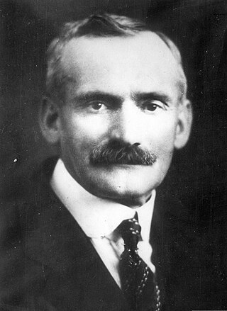
Erland Lee was a Canadian farmer, teacher, and government employee from Stoney Creek, Ontario. He was a co-founder of the Women's Institutes, an international organization originally formed to promote the education of isolated rural women.

The Hockley Highlands Inn and Conference Centre, on the East side of 3rd Line Road, Mono, Ontario, south of Dufferin County Road 7, opposite the Hockley Valley Resort, is a hotel and conference centre with 5 main buildings on 200 acres (0.81 km2) of forested land sloping towards the Hockley Valley. It has been closed to the public since May 2007.
Palermo, founded as Hagartown, is a former hamlet in Halton County, Ontario, Canada, within the town of Oakville.


