Melancthon, Ontario

Last updated

Melancthon
Township of Melancthon
Melancthon ON 1.JPG
Melancthon within the Dufferin County.svg
Melancthon Township within Dufferin County
Canada Southern Ontario location map 2.png
Red pog.svg
Melancthon
Melancthon in southern Ontario
Coordinates: 44°9′N80°16′W / 44.150°N 80.267°W / 44.150; -80.267
CountryFlag of Canada (Pantone).svg  Canada
ProvinceFlag of Ontario.svg  Ontario
County Dufferin
Settled1818
IncorporatedJanuary 1, 1853
Government
  MayorDarren White
  Federal riding Dufferin—Caledon
  Prov. riding Dufferin—Caledon
Area
[1]
  Land310.79 km2 (120.00 sq mi)
Population
 (2016) [1]
  Total3,008
  Density9.7/km2 (25/sq mi)
Time zone UTC-5 (EST)
  Summer (DST) UTC-4 (EDT)
Postal Code
L0N
Area code(s) 519, 226, 548
Website melancthontownship.ca

Melancthon is a rural Canadian township in the northwest corner of Dufferin County, Ontario, bordered on the east by Mulmur Township, Amaranth Township and East Luther Grand Valley to the south, Southgate Township to the west, and the Municipality of Grey Highlands to the north. The township does not include the town of Shelburne on its southern border. It has one of the lowest population densities in southwestern Ontario.

Contents

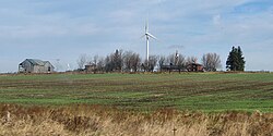
The primary industry of the township is farming, with limited beef, dairy, sheep and horse farming. It is also home to the Melancthon EcoPower Centre wind farm.

The township was founded in 1853 as a part of Grey County and transferred to Dufferin County in 1881. Township council currently comprises Mayor Darren White, Deputy Mayor James McLean, and three councillors.

Wind farm in Melancthon Melancthon ON 2.JPG
Wind farm in Melancthon

Communities

The township of Melancthon comprises a number of villages and hamlets, including the following communities: Auguston, Corbetton, Horning's Mills, Masonville, Mayburne, Melancthon, Ostrander, Redickville, Riverview, Shrigley, and Wrigglesworth Corner.

Demographics

Historical population
YearPop.±%
19912,447    
1996 2,607+6.5%
2001 2,796+7.2%
2006 2,895+3.5%
2011 2,839−1.9%
2016 3,008+6.0%
[2] [3] [1]
Population in 2001 was 2,739 when boundary adjustments in 2006 were taken into account

In the 2021 Census of Population conducted by Statistics Canada, Melancthon had a population of 3,132 living in 1,035 of its 1,104 total private dwellings, a change of

See also

Related Research Articles

<span class="mw-page-title-main">Brighton, Ontario</span> Municipality in Ontario, Canada

Brighton is a town in Northumberland County, Ontario, Canada, approximately 150 kilometres (93 mi) east of Toronto and 100 km (62 mi) west of Kingston. It is traversed by both Highway 401 and the former Highway 2. The west end of the Murray Canal that leads east to the Bay of Quinte is at the east end of the town.

<span class="mw-page-title-main">East Garafraxa</span> Township in Ontario, Canada

East Garafraxa is a rural township located in Dufferin County, Ontario, Canada, to the west of Orangeville and within relative commuting distance of Toronto, Brampton, Guelph, and Kitchener.

<span class="mw-page-title-main">Mono, Ontario</span> Town in Ontario, Canada

Mono is a town situated in south-central Ontario, Canada, at the south-east corner of Dufferin County. It stretches from Highway 9 along its southern border to Highway 89 along its northern border. Its border to the west is with the Township of Amaranth and in the east, it is bordered by the Township of Adjala-Tosorontio. It was previously known as the Township of Mono.

<span class="mw-page-title-main">Montague, Ontario</span> Township in Ontario, Canada

Montague is a township in eastern Ontario, Canada, in Lanark County on the Rideau River. The township administrative offices are located on Roger Stevens Drive east of Smiths Falls.

<span class="mw-page-title-main">Essa, Ontario</span> Township in Ontario, Canada

Essa is a township in Ontario, Canada, west and south of the city of Barrie in Simcoe County. It is bounded by County Road 90 to its north, County Road 27 to its east, and Ontario Highway 89 to its south. The township is about 100 kilometres (62 mi) from Toronto. The township is well known for its agriculture industry, particularly potato farming. Nearby CFB Borden brings a strong military presence to the area as well, including a high number of Francophone families.

<span class="mw-page-title-main">Shelburne, Ontario</span> Town in Ontario, Canada

Shelburne is a town in Dufferin County, Ontario, Canada, is located at the intersection of Highway 10 and Highway 89. Shelburne hosts the Annual Canadian Championship Old Time Fiddling Contest that is held each August.

<span class="mw-page-title-main">East Hawkesbury</span> Township in Ontario, Canada

East Hawkesbury is a township in eastern Ontario, Canada, in the United Counties of Prescott and Russell. Situated on the Ottawa River, its eastern boundary is the border with the province of Quebec.

<span class="mw-page-title-main">Dufferin County</span> County in Ontario, Canada

Dufferin County is a county and census division located in Central Ontario, Canada. The county seat is Orangeville, and the current Warden is Wade Mills. The current chief administrative officer is Sonya Pritchard. Dufferin covers an area of 1,486.31 square kilometres (573.87 sq mi), and its population was 61,735 at the time of the 2016 Census.

<span class="mw-page-title-main">Grey County</span> County in Ontario, Canada

Grey County is a county of the Canadian province of Ontario. The county seat is in Owen Sound. It is located in the subregion of Southern Ontario named Southwestern Ontario. Grey County is also a part of the Georgian Triangle. At the time of the Canada 2016 Census the population of the county was 93,830.

<span class="mw-page-title-main">Perth County, Ontario</span> County in Ontario, Canada

Perth County is a county in the Canadian province of Ontario in Southwestern Ontario, 100 kilometres (62 mi) west of Toronto. Its population centres are Listowel, Mitchell and Milverton. The City of Stratford and the Town of St. Marys are within the Perth census division, but are separate from Perth County. The 2016 population of Perth County was 38,066.

<span class="mw-page-title-main">Clearview, Ontario</span> Township in Ontario, Canada

Clearview is a rural incorporated township in Simcoe County in Central Ontario, Canada, west of Barrie and south of Collingwood and Wasaga Beach in Simcoe County.

<span class="mw-page-title-main">Thames Centre</span> Municipality in Ontario, Canada

Thames Centre is a municipality in Middlesex County, Ontario, Canada, directly east of the City of London. It was formed on January 1, 2001, when the townships of West Nissouri and North Dorchester were amalgamated. It is part of the London census metropolitan area.

<span class="mw-page-title-main">Mulmur</span> Township in Ontario, Canada

Mulmur is a township in Dufferin County in Southern Ontario, Canada. There are a number of original settlements such as Mulmur Corners, some of which can still be identified as to location, including Rosemont and Stanton.

<span class="mw-page-title-main">Laurentian Valley</span> Township municipality in Ontario, Canada

Laurentian Valley is a township municipality in Renfrew County in eastern Ontario, Canada. It borders on the Ottawa River, the city of Pembroke and the town of Petawawa.

<span class="mw-page-title-main">Amaranth, Ontario</span> Township in Ontario, Canada

Amaranth is a township located in Dufferin County, Ontario, Canada, with a 2011 population of 3,963. It is named after the plant which grows abundantly within its borders. It is bordered by Mono to the east and East Luther to the west.

<span class="mw-page-title-main">Howick, Ontario</span> Township in Ontario, Canada

The Township of Howick is a municipality in Huron County, Ontario, Canada. It is located in the northeast corner of Huron County near the Bruce County border, east of Wingham.

<span class="mw-page-title-main">Ashfield–Colborne–Wawanosh</span> Township in Ontario, Canada

The Township of Ashfield–Colborne–Wawanosh is a municipality in Huron County, Ontario, Canada. It was formed as an amalgamation of the former Ashfield, Colborne and West Wawanosh townships in 2001, in an Ontario-wide local government restructuring imposed by the government of that time. The three former townships now comprise the wards of the amalgamated municipality. Mayor of Dungannon Robert Brindley Jr.

<span class="mw-page-title-main">Huron East, Ontario</span> Municipality in Ontario, Canada

The Municipality of Huron East is a Canadian municipality located in Huron County, Ontario. It was formed in 2001 as an amalgamation of the former Grey, McKillop and Tuckersmith townships with the town of Seaforth and village of Brussels, due to an Ontario-wide local government restructuring imposed by the government of that time. The municipality is structured as five wards based on the former townships, town and village.

The Municipality of Morris-Turnberry is a municipality in Huron County, Ontario, Canada. It is located in the north portion of Huron County, near the Bruce County border, southeast of Wingham.

<span class="mw-page-title-main">Grand Valley, Ontario</span> Town in Ontario, Canada

Grand Valley is a town in the Canadian province of Ontario. It comprises the former Township of East Luther and the former Village of Grand Valley. The town is located within Dufferin County, and includes part of the Luther Marsh. The marsh covers over 10,000 acres (40 km²) including Luther Lake. The Grand River is one of the major sites in the town.

References

  1. 1 2 3 "Census Profile, 2016 Census: Melancthon, Township". Statistics Canada. 8 February 2017. Retrieved June 11, 2019.
  2. Statistics Canada: 1996, 2001, 2006 census
  3. "Melancthon, Ontario (Code 3522019) census profile". 2011 Census of Population . Statistics Canada. Retrieved 2012-08-14.
  4. "Population and dwelling counts: Canada, provinces and territories, census divisions and census subdivisions (municipalities), Ontario". Statistics Canada. February 9, 2022. Retrieved April 2, 2022.