Amaranth, Ontario

Last updated

Amaranth
Township of Amaranth
Amaranth within the Dufferin County.svg
Amaranth within the Dufferin County
Canada Southern Ontario location map 2.png
Red pog.svg
Amaranth
Coordinates: 43°59′N80°14′W / 43.983°N 80.233°W / 43.983; -80.233
CountryFlag of Canada (Pantone).svg  Canada
ProvinceFlag of Ontario.svg  Ontario
County Dufferin
IncorporatedJanuary 2, 1854
Government
  MayorChris Gerrits
  Federal riding Dufferin—Caledon
  Prov. riding Dufferin—Caledon
Area
[1]
  Land264.50 km2 (102.12 sq mi)
Population
 (2021) [2]
  Total4,327
  Density15.0/km2 (39/sq mi)
Time zone UTC-5 (EST)
  Summer (DST) UTC-4 (EDT)
FSA
L9V & L9W
Area code 519 / 226 / 548
Website www.amaranth.ca

Amaranth is a township located in Dufferin County, Ontario, Canada, with a 2021 population of 4,327. It is named after the plant which grows abundantly within its borders. It is bordered by Mono to the east and East Luther to the west.

Contents

The hamlet of Laurel is located on the 5th Line (or County Road 12) and 10th Sideroad (or County Road 10). Laurelwoods Elementary School is located just outside this community, on the 6th Line and 10th Sideroad. The township building is also at this location, and has a park with baseball diamonds and soccer fields on its property.

Amaranth's system of naming roads is similar to that of the Dufferin County townships of Mono and Mulmur, and the Simcoe County townships of Adjala and Tosorontio. The system names roads running parallel to Highway 10 in Amaranth "Lines." Each is assigned a number from the town line westward in sequence. Roads running perpendicular to the Lines are numbered Sideroads, and are numbered using multiples of five ascending northward from County Road 109.

Communities

The township of Amaranth comprises a number of villages and hamlets, including the following communities such as Amaranth Station, Blacks Corners, Bowling Green, Campania, Crombie, Farmington, Fraxa, Jessopville, Laurel, Laurel Station, Maple Grove, Waldemar, Whittington; Bates' Corners, Coleridge, Fern Bank, Hall's Corners, Kennedy's Corners, Rich Hill, The Gore

Demographics

In the 2021 Census of Population conducted by Statistics Canada, Amaranth had a population of 4,327 living in 1,372 of its 1,428 total private dwellings, a change of 6.1% from its 2016 population of 4,079. With a land area of 265.02 km2 (102.32 sq mi), it had a population density of 16.3/km2 (42.3/sq mi) in 2021. [3]

Canada census – Amaranth community profile
2021 2011
Population4,327 (+6.1% from 2016)3,963 (+3.1% from 2006)
Land area265.02 km2 (102.32 sq mi)264.5 km2 (102.1 sq mi)
Population density16.3/km2 (42/sq mi)15.0/km2 (39/sq mi)
Median age42.4 (M: 42.0, F: 43.2)42.5 (M: 42.4, F: 42.5)
Private dwellings1,428 (total)  1,372 (occupied)1,312 (total) 
Median household income$127,000
References: 2021 [4] 2011 [1] earlier [5] [6]

Population trend: [7]

See also

Related Research Articles

<span class="mw-page-title-main">Caledon, Ontario</span> Town in Ontario, Canada

Caledon is a town in the Regional Municipality of Peel in the Greater Toronto Area of Ontario, Canada. The name comes from a shortened form of Caledonia, the Roman name for what is now Scotland. Caledon is primarily rural with a number of hamlets and small villages, but also contains the larger community of Bolton in its southeastern quadrant, adjacent to York Region. Some spillover urbanization also occurs in the south bordering the City of Brampton.

<span class="mw-page-title-main">East Garafraxa</span> Township in Ontario, Canada

East Garafraxa is a rural township located in Dufferin County, Ontario, Canada, to the west of Orangeville and within relative commuting distance of Toronto, Brampton, Guelph, and Kitchener.

<span class="mw-page-title-main">Mono, Ontario</span> Town in Ontario, Canada

Mono is a town situated in south-central Ontario, Canada, at the south-east corner of Dufferin County. It stretches from Highway 9 along its southern border to Highway 89 along its northern border. Its border to the west is with the Township of Amaranth and in the east, it is bordered by the Township of Adjala-Tosorontio. It was previously known as the Township of Mono.

<span class="mw-page-title-main">North Grenville</span> Municipality in Ontario, Canada

North Grenville is a township in eastern Ontario, Canada, in the United Counties of Leeds and Grenville on the Rideau River. It is located just south of Ottawa in Canada's National Capital Region.

<span class="mw-page-title-main">Montague, Ontario</span> Township in Ontario, Canada

Montague is a township in eastern Ontario, Canada, in Lanark County on the Rideau River. The township administrative offices are located on Roger Stevens Drive east of Smiths Falls.

<span class="mw-page-title-main">Champlain, Ontario</span> Township in Ontario, Canada

Champlain is a township in eastern Ontario, Canada, in the United Counties of Prescott and Russell on the Ottawa River. It was formed on January 1, 1998, through the amalgamation of West Hawkesbury Township, Longueuil Township, Town of Vankleek Hill, and the Village of L'Orignal.

<span class="mw-page-title-main">Dawn-Euphemia</span> Township in Ontario, Canada

Dawn-Euphemia is a township in southwestern Ontario, Canada, in Lambton County. Residents primarily are employed by the agricultural industry, or by local industries such as Union Gas distribution centre, along with various smaller agricultural manufacturers or service providers. The township municipal office is located in Rutherford.

<span class="mw-page-title-main">Tay Valley, Ontario</span> Township in Ontario, Canada

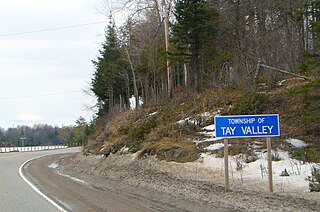
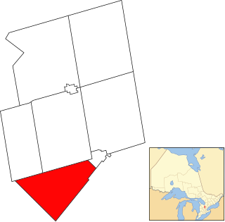
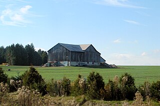
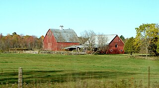
Tay Valley is a township in eastern Ontario, Canada, on the Tay River in the southwest corner of Lanark County, adjacent to the United Counties of Leeds and Grenville and Frontenac County. The township administrative offices are located in Glen Tay.

<span class="mw-page-title-main">Seguin, Ontario</span> Township in Ontario, Canada

Seguin is a township in central Ontario, Canada, in the District of Parry Sound.

<span class="mw-page-title-main">Grey County</span> County in Ontario, Canada

Grey County is a county of the Canadian province of Ontario. The county seat is in Owen Sound. It is located in the subregion of Southern Ontario named Southwestern Ontario. Grey County is also a part of the Georgian Triangle. At the time of the Canada 2016 Census the population of the county was 93,830.

<span class="mw-page-title-main">Mulmur</span> Township in Ontario, Canada

Mulmur is a township in Dufferin County in Southern Ontario, Canada. There are a number of original settlements such as Mulmur Corners, some of which can still be identified as to location, including Rosemont and Stanton.

<span class="mw-page-title-main">Laurentian Valley</span> Township municipality in Ontario, Canada

Laurentian Valley is a township municipality in Renfrew County in eastern Ontario, Canada. It borders on the Ottawa River, the city of Pembroke and the town of Petawawa.

<span class="mw-page-title-main">Arran–Elderslie</span> Municipality in Ontario, Canada

The Municipality of Arran–Elderslie is a township in Bruce County in Western Ontario, Canada. The township is located at the headwaters of the Sauble River, and the Saugeen River forms the northwestern boundary.

<span class="mw-page-title-main">Howick, Ontario</span> Township in Ontario, Canada

The Township of Howick is a municipality in Huron County, Ontario, Canada. It is located in the northeast corner of Huron County near the Bruce County border, east of Wingham.

<span class="mw-page-title-main">Bayham</span> Municipality in Ontario, Canada

Bayham is a municipality in the southeast corner of Elgin County, Ontario, Canada. It is south of the town of Tillsonburg and Oxford County.

<span class="mw-page-title-main">Melancthon, Ontario</span> Township in Ontario, Canada

Melancthon is a rural Canadian township in the northwest corner of Dufferin County, Ontario, bordered on the east by Mulmur Township, Amaranth Township and East Luther Grand Valley to the south, Southgate Township to the west, and the Municipality of Grey Highlands to the north. The township does not include the town of Shelburne on its southern border. It has one of the lowest population densities in southwestern Ontario.

<span class="mw-page-title-main">Southwest Middlesex, Ontario</span> Municipality in Ontario, Canada

Southwest Middlesex is a municipality in Middlesex County, Ontario, Canada.

Malahide is a municipal township in Elgin County in southwestern Ontario, Canada.

<span class="mw-page-title-main">Grand Valley, Ontario</span> Town in Ontario, Canada

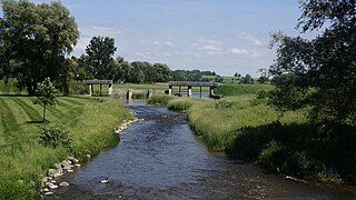
Grand Valley is a town in the Canadian province of Ontario. It comprises the former Township of East Luther and the former Village of Grand Valley. The town is located within Dufferin County, and includes part of the Luther Marsh. The marsh covers over 10,000 acres (40 km²) including Luther Lake. The Grand River is one of the major sites in the town.

<span class="mw-page-title-main">North Algona Wilberforce</span> Township municipality in Ontario, Canada

North Algona Wilberforce is a township municipality in Renfrew County, Ontario, Canada. It has a population of 2,873. The township was formed in 1999 when the North Algona and Wilberforce townships were amalgamated.

References

  1. 1 2 "2011 Community Profiles". 2011 Canadian Census . Statistics Canada. March 21, 2019. Retrieved 2012-05-01.
  2. "Population and dwelling counts: Canada, provinces and territories, census divisions and census subdivisions (municipalities), Ontario". Statistics Canada. February 9, 2022. Retrieved April 2, 2022.
  3. "Population and dwelling counts: Canada, provinces and territories, census divisions and census subdivisions (municipalities), Ontario". Statistics Canada. February 9, 2022. Retrieved April 2, 2022.
  4. "2021 Community Profiles". 2021 Canadian Census . Statistics Canada. February 4, 2022. Retrieved 2023-10-19.
  5. "2006 Community Profiles". 2006 Canadian Census . Statistics Canada. August 20, 2019.
  6. "2001 Community Profiles". 2001 Canadian Census . Statistics Canada. July 18, 2021.
  7. Statistics Canada: 1996, 2001, 2006, 2011 census