
Rufiji is one of the six districts of the Pwani Region of Tanzania. It is bordered to the north by the Kisarawe and Mkuranga Districts, to the east by the Indian Ocean, to the south by the Kilwa District, Lindi Region and to the west by the Morogoro Region. The district capital is the town of Utete on the southern banks of the Rufiji River.

Pwani Region is one of Tanzania's 31 administrative regions. The word "Pwani" in Swahili means the "coast". With the town of Kibaha serving as the capital, the region borders the Tanga Region to the north, Morogoro Region to the west, Lindi Region to the south, and surrounds Dar es Salaam Region to the east. The Indian Ocean also borders the region to its northeast and southeast. The region is home to Mafia Island, the Rufiji delta and Saadani National Park. The region is home to Bagamoyo town, a historical Swahili settlement, and the first colonial capital of German East Africa. According to the 2012 national census, the region had a population of 1,098,668, which was slightly lower than the pre-census projection of 1,110,917. From 2002 to 2012, the region's 2.2 percent average annual population growth rate was the seventeenth-highest in the country. It was also the 21st most densely populated region with 34 people per square kilometre., According to the 2022 census the population had nearly doubled to 2,024,947. The region is slightly larger than Belgium.
Kibaha is a city, with a population of 265,360, located in eastern Tanzania. It is the capital of Pwani Region. It is located in Kibaha District, one of the six districts of Pwani Region.

Ubungo District, officially the, Ubungo Municipal Council is one of five districts of the Dar es Salaam Region of Tanzania. The Kinondoni District and Kibaha of the Pwani Region border the district to the north; the Kisarawe District of Pwani Region borders it to the west; and the Ilala District borders the it to the south and east. The district covers an area of 269.4 km2 (104.0 sq mi). The district is comparable in size to the land area of St. Kitts and Nevis. The administrative seat is Kwembe. The district is home to the University of Dar es Salaam, The Magufuli Bus Terminal, the largest in the country, and Pande Game Reserve the largest protected land area in Dar es Salaam Region. In addition, the district is home to the largest natural gas powered power station, the Ubungo Thermal Power Station and the headquarters of the Tanzania Electric Supply Company Limited (TANESCO). The 2022 census states the population of the district as 1,086,912.

Kisarawe District Council is one of eight administrative districts of Pwani Region in Tanzania. The District covers an area of 5,031 km2 (1,942 sq mi). It is bordered to the east by Dar es Salaam Region's Ilala and Ubungo Municipal Councils. The Kibaha District and Kibaha Town Council border the district to the north, and the Mkuranga District and Kibiti District border it to the south-east. By the Rufiji District to the south, and the Morogoro District of the Morogoro Region to the west. The district is comparable in size to the land area of Trinidad and Tobago. The town of Kisarawe serves as its administrative capital. According to the 2022 Tanzania National Census, the population of the District was 159,226.

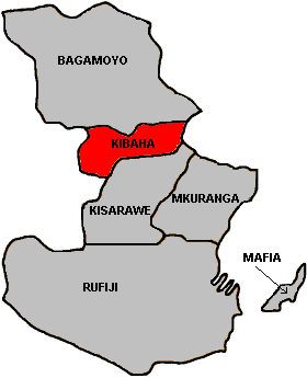
Kibaha is one of nine administrative districts of Pwani Region in Tanzania. The name means '"it is here" in Zaramo. The district covers an area of 1,502 km2 (580 sq mi). Kibaha is bordered to the northeast by Kibaha Urban District and the north by Chalinze District. The district is bordered to the southeast by the Kisarawe District, On the western side the district is bordered by Morogoro District of Morogoro Region. The district seat (capital) is the town and ward of Mlandizi. According to the 2022 census, the district has a total population of 123,367.
Soga is a village and a ward in the Pwani Region of Tanzania. It is located in Kibaha District. It is bordered to the east by Bokomnemela ward, to the west by Kikongo ward, to the north by Chalinze District and to the south by Kisarawe District. According to the 2022 census, the population of Soga is 10,283.

The Ruvu River is a river in eastern Tanzania.

Mlandizi is an administrative ward and capital of Kibaha District in Pwani Region of Tanzania.
Bokomnemela is a ward in the Pwani Region of Tanzania. It is located in Kibaha District. It is bordered to the west by Soga ward, to the north by Kibaha city and to the south and east by Kisarawe District. According to the 2022 census, the population of Bokomnemela is 6,871.
Gwata is a ward in the Pwani Region of Tanzania. It is located in Kibaha District. According to the 2022 census, the population of Soga is 10,283. There are 2,842 males and 2,979 females. There are 2,979 households with an average household size of 3.7. The ward covers an area of 126 km2 (49 sq mi). It has 1,956 buildings in total.
Janga is a ward in the Pwani Region of Tanzania. It is located in Kibaha District. According to the 2022 census, the population of Janga is 15,524, making it the highest-populated ward in Kibaha. There are 7,335 males and 8,189 females. There are 4,639 households with an average household size of 3.3. The ward covers an area of 3.471 km2 (1.340 sq mi). It has 2,682 buildings in total.
Kawawa is a ward in the Pwani Region of Tanzania. It is located in Kibaha District.
Kikongo is a ward in the Pwani Region of Tanzania. It is located in Kibaha District.
Kilangalanga is a ward in the Pwani Region of Tanzania. It is located in Kibaha District. According to the 2022 census, the population of Kilangalanga is 2,657. There are 4,784 males and 5,200 females. There are 2,819 households with an average household size of 3.5. The ward covers an area of 16.84 km2 (6.50 sq mi). It has 1,946 buildings in total.
Kwala is a ward in the Pwani Region of Tanzania. It is located in Kibaha District.
Magindu is a ward in the Pwani Region of Tanzania. It is located in Kibaha District.
Mtambani is a ward in the Pwani Region of Tanzania. It is located in Kibaha District.
Mtongani is a ward in the Pwani Region of Tanzania. It is located in Kibaha District.