Related Research Articles

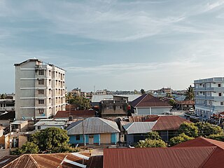
Dar es Salaam is the largest city and financial hub of Tanzania. It is also the capital of the Dar es Salaam Region. With a population of over five million people, Dar es Salaam is the largest city in East Africa and the sixth-largest in Africa. Located on the Swahili coast, Dar es Salaam is an important economic center and one of the fastest-growing cities in the world.
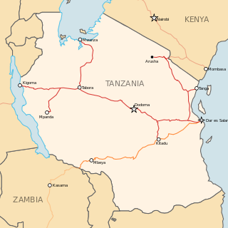
Transport in Tanzania includes road, rail, air and maritime networks. The road network is 86,472 kilometres (53,731 mi) long, of which 12,786 kilometres (7,945 mi) is classified as trunk road and 21,105 kilometres (13,114 mi) as regional road. The rail network consists of 3,682 kilometres (2,288 mi) of track. Commuter rail service is in Dar es Salaam only. There are 28 airports, with Julius Nyerere International being the largest and the busiest. Ferries connect Mainland Tanzania with the islands of Zanzibar. Several other ferries are active on the countries' rivers and lakes.
Tanga is a historic city and the capital of Tanga Region. The city is the most northernly port city of Tanzania to the west of the Indian Ocean on Tanga Bay. The city has a population of 393,429 in 2022. Tanga is governed by the Tanga City Council. The city is also home to the Port of Tanga. The name Tanga means "sail" in Swahili. The city is also the capital of Tanga District.

Dar es Salaam Region is one of Tanzania's 31 administrative regions and is located in the east coast of the country. The region covers an area of 1,393 km2 (538 sq mi). The region is comparable in size to the combined land and water areas of the nation state of Mauritius. Dar es Salaam Region is bordered to the east by Indian Ocean and it is entirely surrounded by Pwani Region. The Pwani districts that border Dar es Salaam region are Bagamoyo District to the north, Kibaha Urban District to the west, Kisarawe District to the south west and Mkuranga District to the south of the region. The region's seat (capital) is located inside the ward of Ilala. The region is named after the city of Dar es Salaam itself. The region is home to Tanzania's major finance, administration and industries, thus the making it the country's richest region. The region also has the second highest Human Development Index in the country after Mjini Magharibi. According to the 2022 census, the region has a total population of 5,383,728. The region has the highest population in Tanzania followed by Mwanza Region.

Mtwara is the capital city of Mtwara Region in southeastern Tanzania. In the 1940s, it was planned and constructed as the export facility for the disastrous Tanganyika groundnut scheme, but was somewhat neglected when the scheme was abandoned in 1951. The city is spread out over a large area planned to accommodate up to 200,000 people. The present population is around 141,000. As part of the development associated with the failed Tanganyika groundnut scheme, Mtwara features a deep-water port that can accommodate ocean-going vessels, and a range of large municipal buildings, including a post office. Recent improvements in the port made it possible for big container ships to berth there.

Ilala District, officially the Ilala Municipal Council is one of five districts of the Dar es Salaam Region of Tanzania. The district is bordered to the north and northeast by Kinondoni District and Ubungo District, to the east by the Zanzibar Channel, the west by Pwani Region, and to the south by the Temeke District. It covers an area of 364.9 km2 (140.9 sq mi). The district is comparable in size to the land area of U.S Virgin Islands. The administrative seat is Mchafukoge. The 2022 National Tanzania Census states the population for Ilala as 1,649,912.

A dry port is an inland intermodal terminal directly connected by road or rail to a seaport, operating as a centre for the transshipment of sea cargo to inland destinations.
Adani Ports and Special Economic Zone Limited (APSEZ) is an Indian multinational port operator and logistics company, part of Adani Group. APSEZ is India's largest private port operator with a network of 12 ports and terminals, including India's first port-based SEZ at Mundra and the first deep water transshipment port at Thiruvananthapuram.
Railway stations in Tanzania include:

Kurasini is an administrative ward in the Temeke district of the Dar es Salaam Region of Tanzania. Home of The Dar es Salaam Port, It is the location of the Port of Dar es Salaam; the fourth-largest port in Africa on the Indian Ocean, The National Police College, the Mgulani Police Barracks, Tanzania Immigration Headquarters, Diplomacy College and the Dar es Salaam International Trade Fair Grounds. Kurasini, under the British occupation of Tanganyika was built before 1940 for European port officials only. According to the 2012 census, the ward has a total population of 26,193.
Ruvu is a small town and ward (shehia) located in the Kibaha District of the Pwani Region in eastern Tanzania, west of Dar es Salaam. As of 2022, the ward population was 4,111.

Tanzania Ports Authority (TPA) is a parastatal public corporation acting under the aegis of the Ministry of Infrastructure Development, that has the responsibility "to manage and operate" the ocean ports and lake ports of the country of Tanzania. The Tanzania Ports Authority headquarters are located in Mchafukoge ward of Ilala District in Dar es Salaam Region. It is a member of the Port Management Association of Eastern and Southern Africa.

Kibaha is one of nine administrative districts of Pwani Region in Tanzania. The name means '"it is here" in Zaramo. The district covers an area of 1,502 km2 (580 sq mi). Kibaha is bordered to the northeast by Kibaha Urban District and the north by Chalinze District. The district is bordered to the southeast by the Kisarawe District, On the western side the district is bordered by Morogoro District of Morogoro Region. The district seat (capital) is the town and ward of Mlandizi. According to the 2022 census, the district has a total population of 123,367.
Northern Corridor is a busy and important transport route to the East and Central Africa countries of Burundi, Eastern DR Congo, Kenya, Rwanda, South Sudan and Uganda.

The Port of Dar es Salaam is the principal port serving Tanzania located in Kurasini ward of Temeke District of Dar es Salaam Region. The port is one of three ocean ports in the country and handles over 90% of the country's cargo traffic. According to the International Association of Ports and Harbors, it is the fourth largest port on the African continent's Indian Ocean coastline after Durban, Mombasa and Maputo. The port acts as a gateway for commerce and trade for Tanzania and numerous bordering landlocked states.
Energy in Tanzania is fundamental to the nation's projected economic growth, with estimates indicating that the economy could expand sevenfold by 2040, while energy demand is expected to increase by only 150% due to advancements in fuel efficiency. The country is actively enhancing its energy mix, primarily relying on natural gas for more than half of its electricity generation and significant contributions from hydropower, with oil primarily used for backup power. Tanzania has a wide range of energy resources in abundance, which are not yet fully exploited. These include; wood fuel, other biomass fuels, hydropower, natural gas, coal, wind, geothermal, uranium and solar.
The Isaka–Kigali Standard Gauge Railway is a planned railway line linking the town of Isaka in Tanzania to the city of Kigali in Rwanda.
The Masaka Inland Container Depot (MICD), is a dry port, in Kigali, the capital city and largest city of Rwanda.
Soga is a village and a ward in the Pwani Region of Tanzania. It is located in Kibaha District. It is bordered to the east by Bokomnemela ward, to the west by Kikongo ward, to the north by Chalinze District and to the south by Kisarawe District. According to the 2022 census, the population of Soga is 10,283.
Gwata is a ward in the Pwani Region of Tanzania. It is located in Kibaha District. According to the 2022 census, the population of Soga is 10,283. There are 2,842 males and 2,979 females. There are 2,979 households with an average household size of 3.7. The ward covers an area of 126 km2 (49 sq mi). It has 1,956 buildings in total.
References
- ↑ "Administrative Units: Population Distribution Report" (PDF). National Bureau of Statistics. Retrieved 2 August 2024.
- ↑ "Kibaha (District, Tanzania) - Population Statistics, Charts, Map and Location". www.citypopulation.de. Retrieved 2024-08-06.
- ↑ "Tanzania Building Census 2022: Basic Statistics Report" (PDF). National Bureau of Statistics. Retrieved 6 August 2024.
- ↑ Okafor, Chinedu (2023-02-07). "See the Tanzanian city project expected to provide 1000 jobs in over 200 industries". Business Insider Africa. Retrieved 2024-08-06.
- ↑ "Kwala Dry Port to handle over 300,000 cargo containers annually". The Citizen. 2024-05-16. Retrieved 2024-08-06.