
Olympus Mons is a large shield volcano on Mars. It is over 21.9 km high as measured by the Mars Orbiter Laser Altimeter (MOLA), about 2.5 times the elevation of Mount Everest above sea level. It is Mars's tallest volcano, its tallest planetary mountain, and is approximately tied with Rheasilvia on Vesta as the tallest mountain currently discovered in the Solar System. It is associated with the volcanic region of Tharsis Montes. It last erupted 25 million years ago.
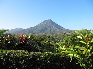
Arenal Volcano is an active andesitic stratovolcano in north-western Costa Rica around 90 km (56 mi) northwest of San José, in the province of Alajuela, canton of San Carlos, and district of La Fortuna. The Arenal volcano measures at least 1,633 metres (5,358 ft) high. It is conically shaped with a crater 140 metres (460 ft) in diameter. Geologically, Arenal is considered a young volcano and it is estimated to be less than 7,500 years old. It is also known as "Pan de Azúcar", "Canaste", "Volcan Costa Rica", "Volcan Río Frío" or "Guatusos Peak".

Alba Mons is a volcano located in the northern Tharsis region of the planet Mars. It is the biggest volcano on Mars in terms of surface area, with volcanic flow fields that extend for at least 1,350 km (840 mi) from its summit. Although the volcano has a span comparable to that of the United States, it reaches an elevation of only 6.8 km (22,000 ft) at its highest point. This is about one-third the height of Olympus Mons, the tallest volcano on the planet. The flanks of Alba Mons have very gentle slopes. The average slope along the volcano's northern flank is 0.5°, which is over five times lower than the slopes on the other large Tharsis volcanoes. In broad profile, Alba Mons resembles a vast but barely raised welt on the planet's surface. It is a unique volcanic structure with no counterpart on Earth or elsewhere on Mars.

Aracar is a large conical stratovolcano in northwestern Argentina, just east of the Chilean border. It has a main summit crater about 1–1.5 kilometres (0.6–0.9 mi) in diameter which sometimes contains crater lakes, and a secondary crater. The volcano has formed, starting during the Pliocene, on top of a lava platform and an older basement. Constructed on a base with an altitude of 4,100 metres (13,500 ft), it covers a surface area of 192.4 square kilometres (74.3 sq mi) and has a volume of 148 cubic kilometres (36 cu mi). The only observed volcanic activity was a possible steam or ash plume on March 28, 1993, seen from the village of Tolar Grande about 50 km (31 mi) southeast of the volcano, but with no evidence of deformation of the volcano from satellite observations. Inca archeological sites are found on the volcano.

Falso Azufre is a complex volcano at the border of Argentina and Chile.

The geology of Venus is the scientific study of the surface, crust, and interior of the planet Venus. Within the Solar System, it is the one nearest to Earth and most like it in terms of mass, but has no magnetic field or recognizable plate tectonic system. Much of the ground surface is exposed volcanic bedrock, some with thin and patchy layers of soil covering, in marked contrast with Earth, the Moon, and Mars. Some impact craters are present, but Venus is similar to Earth in that there are fewer craters than on the other rocky planets that are largely covered by them. This is due in part to the thickness of the Venusian atmosphere disrupting small impactors before they strike the ground, but the paucity of large craters may be due to volcanic re-surfacing, possibly of a catastrophic nature. Volcanism appears to be the dominant agent of geological change on Venus. Some of the volcanic landforms appear to be unique to the planet. There are shield and composite volcanoes similar to those found on Earth, although these volcanoes are significantly shorter than those found on Earth or Mars. Given that Venus has approximately the same size, density, and composition as Earth, it is plausible that volcanism may be continuing on the planet today, as demonstrated by recent studies.

Lascar is a stratovolcano in Chile within the Central Volcanic Zone of the Andes, a volcanic arc that spans Peru, Bolivia, Argentina and Chile. It is the most active volcano in the region, with records of eruptions going back to 1848. It is composed of two separate cones with several summit craters. The westernmost crater of the eastern cone is presently active. Volcanic activity is characterized by constant release of volcanic gas and occasional vulcanian eruptions.

Mount Hibok-Hibok is a stratovolcano on Camiguin Island in the Philippines. One of the active volcanoes in the country, it is part of the Pacific ring of fire.

Incahuasi is a volcanic mountain in the Andes of South America. It lies on the border of the Catamarca Province of Argentina and the Atacama Region of Chile. Incahuasi has a summit elevation of 6,621 metres (21,722 ft) above sea level.

Nevado de Longaví is a volcano in the Andes of central Chile. The 3,242 m (10,636 ft) high volcano lies in the Linares Province, which is part of the Maule Region. It features a summit crater and several parasitic vents. The volcano is constructed principally from lava flows. Two collapses of the edifice have carved collapse scars into the volcano, one on the eastern slope known as Lomas Limpias and another on the southwestern slope known as Los Bueye. The volcano features a glacier and the Achibueno and Blanco rivers originate on the mountain.

Aucanquilcha is a massive stratovolcano located in the Antofagasta Region of northern Chile, just west of the border with Bolivia and within the Alto Loa National Reserve. Part of the Central Volcanic Zone of the Andes, the stratovolcano has the form of a ridge with a maximum height of 6,176 metres (20,262 ft). The volcano is embedded in a larger cluster of volcanoes known as the Aucanquilcha cluster. This cluster of volcanoes was formed in stages over eleven million years of activity with varying magma output, including lava domes and lava flows. Aucanquilcha volcano proper is formed from four units that erupted between 1.04–0.23 million years ago. During the ice ages, both the principal Aucanquilcha complex and the other volcanoes of the cluster were subject to glaciation, resulting in the formation of moraines and cirques.

Ollagüe or Ullawi is a massive andesite stratovolcano in the Andes on the border between Bolivia and Chile, within the Antofagasta Region of Chile and the Potosi Department of Bolivia. Part of the Central Volcanic Zone of the Andes, its highest summit is 5,868 metres (19,252 ft) above sea level and features a summit crater that opens to the south. The western rim of the summit crater is formed by a compound of lava domes, the youngest of which features a vigorous fumarole that is visible from afar.

Mount Tendürek is a shield volcano on the border of Ağrı and Van provinces in eastern Turkey, near the border with Iran. The volcano, which is mostly known for being near the supposed wreck site of Noah's Ark, is very large; its lava flows cover roughly 650 km2 (251 sq mi) across a swath of flat land. The mountain's two main features are the main summit crater Greater Tendürek, and a smaller crater known as Lesser Tendürek which lies to the east of the main crater. The slopes are very gentle and resemble a shield, after which the type is named. Mount Tendürek is known to have erupted viscous lava like that of volcanoes on the island of Hawaii.
Chiliques is a stratovolcano located in the Antofagasta Region of Chile.

Taapaca is a Holocene volcanic complex in northern Chile's Arica y Parinacota Region. Located in the Chilean Andes, it is part of the Central Volcanic Zone of the Andean Volcanic Belt, one of four distinct volcanic chains in South America. The town of Putre lies at the southwestern foot of the volcano.

Volcán Putana, sometimes referred to as Jorqencal or Machuca, is a stratovolcano located In the Central Volcanic Zone (CVZ) of the Andes on the border between Bolivia and Chile and close to the Sairecabur volcanic complex. Its summit is 5,884 metres (19,304 ft) above sea level and contains a summit crater with two smaller craters nested within it. Beneath the summit, the volcano features a number of lava domes and lava flows, some of which originated in flank vents.

Olca-Paruma is a volcanic complex in Chile. Lying on the border between Chile and Bolivia, it is formed by an east–west alignment of volcanoes. From west to east, these are Cerro Paruma, Volcan Paruma, Olca, and Mencheca or Michincha. Aside from the mines of Ujina, Rosario, and Quebrada Blanca, the area is sparsely populated.

Ticsani is a volcano in Peru northwest of Moquegua and consists of two volcanoes that form a complex. "Old Ticsani" is a compound volcano that underwent a large collapse in the past and shed 15–30 cubic kilometres (3.6–7.2 cu mi) of mass down the Rio Tambo valley. Today an arcuate ridge remains of this edifice. "Modern Ticsani" is a complex of three lava domes which were emplaced during the Holocene. Two large eruptions took place during the Holocene, producing the so-called "Grey Ticsani" and "Brown Ticsani" deposits; the last eruption occurred after the 1600 eruption of neighbouring Huaynaputina. The volcano is seismically active and features active hot springs and fumaroles; since 2015 the volcano is monitored by the Peruvian government.
Tocorpuri is a volcano in Chile, close to the border with Bolivia. Its peak height is most recently given as 5,808 metres (19,055 ft) and it features a 1.3 kilometres (0.81 mi) wide summit crater. The volcano consists mainly of lava flows and pyroclastic deposits and is subdivided into two separate edifices. Just west of Tocorpuri, the La Torta lava dome is a 200 metres (660 ft) high flat-topped structure. The volcanoes are formed by andesitic, dacitic and rhyolitic rocks.

Volcanism on the Moon is represented by the presence of volcanoes, pyroclastic deposits and vast lava plains on the lunar surface. The volcanoes are typically in the form of small domes and cones that form large volcanic complexes and isolated edifices. Calderas, large-scale collapse features generally formed late in a volcanic eruptive episode, are exceptionally rare on the Moon. Lunar pyroclastic deposits are the result of lava fountain eruptions from volatile-laden basaltic magmas rapidly ascending from deep mantle sources and erupting as a spray of magma, forming tiny glass beads. However, pyroclastic deposits formed by less common non-basaltic explosive eruptions are also thought to exist on the Moon. Lunar lava plains cover large swaths of the Moon's surface and consist mainly of voluminous basaltic flows. They contain a number of volcanic features related to the cooling of lava, including lava tubes, rilles and wrinkle ridges.

