Sachigo River

Last updated
Sachigo River
Country Canada
Province Ontario
Region Northwestern Ontario
District Kenora
Part of Hudson Bay drainage basin
Tributaries
 - leftBeaver Stone River,Thorne River,Sherman River
 - rightWapaseese River, Morrison River,Rottenfish River
SourceBroadside Lake
 - elevation272 m (892 ft)
 - coordinates 53°37′10″N92°38′19″W / 53.61944°N 92.63861°W / 53.61944; -92.63861
Mouth Severn River
 - elevation75 m (246 ft)
 - coordinates 55°04′33″N88°59′02″W / 55.07583°N 88.98389°W / 55.07583; -88.98389 Coordinates: 55°04′33″N88°59′02″W / 55.07583°N 88.98389°W / 55.07583; -88.98389
Length380 km (236 mi)
Dischargefor Sachigo River below Beaverstone River [1]
 - average144.25 m3/s (5,094 cu ft/s)
 - max191.53 m3/s (6,764 cu ft/s)
 - min104.70 m3/s (3,697 cu ft/s)
Canada Ontario relief location map.jpg
Red pog.svg
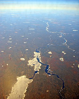
Location of the mouth of the Sachigo River in Ontario

The Sachigo River is a river in the Hudson Bay drainage basin in Kenora District in Northwestern Ontario, Canada. It is a tributary of the Severn River.

River Natural flowing watercourse

A river is a natural flowing watercourse, usually freshwater, flowing towards an ocean, sea, lake or another river. In some cases a river flows into the ground and becomes dry at the end of its course without reaching another body of water. Small rivers can be referred to using names such as stream, creek, brook, rivulet, and rill. There are no official definitions for the generic term river as applied to geographic features, although in some countries or communities a stream is defined by its size. Many names for small rivers are specific to geographic location; examples are "run" in some parts of the United States, "burn" in Scotland and northeast England, and "beck" in northern England. Sometimes a river is defined as being larger than a creek, but not always: the language is vague.

Hudson Bay A large body of saltwater in northeastern Canada that drains much of north-central North America

Hudson Bay is a large body of saltwater in northeastern Canada with a surface area of 1,230,000 km2 (470,000 sq mi). It drains a very large area, about 3,861,400 km2 (1,490,900 sq mi), that includes parts of southeastern Nunavut, Saskatchewan, most of Manitoba, Ontario, Quebec and indirectly through smaller passages of water to parts of North Dakota, South Dakota, Minnesota, and Montana. Hudson Bay's southern arm is called James Bay.

Drainage basin Area of land where precipitation collects and drains off into a common outlet

A drainage basin is any area of land where precipitation collects and drains off into a common outlet, such as into a river, bay, or other body of water. The drainage basin includes all the surface water from rain runoff, snowmelt, and nearby streams that run downslope towards the shared outlet, as well as the groundwater underneath the earth's surface. Drainage basins connect into other drainage basins at lower elevations in a hierarchical pattern, with smaller sub-drainage basins, which in turn drain into another common outlet.

Contents

Course

The Sachigo River begins at Broadside Lake and flows northeast through Pasateko Lake, past the Sachigo Hills, to Sachigo Lake, the location of the Sachigo Lake First Nation and the Sachigo Lake Airport, and where it takes in the right tributary Morrison River. It then heads north, past the Wetiko Hills, to Little Sachigo Lake, exits the lake east and heads once again northeast. The river divides into two branches, takes in the Sherman River on the left branch, then recombines. It continues northeast to reach its mouth at the Severn River, which flows to Hudson Bay.

Sachigo Lake lake in Canada

Sachigo Lake is a lake in Unorganized Kenora District in Northwestern Ontario, Canada. It is on the Sachigo River and is part of the Hudson Bay drainage basin.

Sachigo Lake First Nation Place in Ontario, Canada

Sachigo Lake First Nation is an Oji-Cree First Nation band government in Unorganized Kenora District in Northwestern Ontario, Canada. It is located on Sachigo Lake, part of the Sachigo River system and Hudson Bay drainage basin, approximately 425 kilometres (264 mi) north of the town of Sioux Lookout. As of September 2011, the First Nation had a registered population of 814 people, of which the on-reserve population was 443.

Sachigo Lake Airport

Sachigo Lake Airport,, is located 1.5 nautical miles north of the First Nations community of Sachigo Lake, Ontario, Canada.

Tributaries

See also

Related Research Articles

Kenogami River river in Canada

The Kenogami River is a river in the James Bay drainage basin in Thunder Bay and Cochrane districts in Northern Ontario, Canada, which flows north from Long Lake near Longlac to empty into the Albany River. The river is 320 kilometres (199 mi) in length and its name means "long water" in the Cree language. A portion of the river's headwaters have been diverted into the Lake Superior drainage basin.

Fawn River (Ontario) river in Canada

The Fawn River is a river in the north of the Unorganized Part of Kenora District in Northwestern Ontario, Canada. It is in the Hudson Bay drainage basin and is a right tributary of the Severn River.

Hayes River river in Manitoba, Canada

The Hayes River is a river in Northern Region, Manitoba, Canada that flows from Molson Lake to Hudson Bay at York Factory. It was an historically important river in the development of Canada, and is today a Canadian Heritage River and the longest naturally flowing river in Manitoba.

Albany River river in Ontario, Canada

The Albany River is a river in Northern Ontario, Canada, which flows northeast from Lake St. Joseph in Northwestern Ontario and empties into James Bay. It is 982 kilometres (610 mi) long to the head of the Cat River, tying it with the Severn River for the title of longest river in Ontario. Major tributaries include the Kenogami River and Ogoki River.

Magpie River (Ontario) watercourse in Canada

The Magpie River is a river in Algoma District, northeastern Ontario, Canada, The river empties into Michipicoten Bay on Lake Superior near the town of Wawa. The river drains an area of about 1,900 square kilometres (734 sq mi).

Little Sachigo Lake lake in Canada

Little Sachigo Lake is a lake in Unorganized Kenora District in Northwestern Ontario, Canada. It is on the Sachigo River and is part of the Hudson Bay drainage basin.

Kagiano River river in Canada

The Kagiano River is a river in the east part of Thunder Bay District in northwestern Ontario, Canada. It is in the Great Lakes Basin and flows from Devork Lake, 42 kilometres (26 mi) south of the community of Longlac on Ontario Highway 11, to the Pic River 55 kilometres (34 mi) north northeast of the town of Marathon on Ontario Highway 17.

Night Hawk River watercourse in Canada

The Night Hawk River is a river in the James Bay and Moose River drainage basins in Cochrane and Timiskaming Districts in northeastern Ontario, Canada. It flows 33 kilometres (21 mi) from Austen Lake to its mouth at Night Hawk Lake, the source of the Frederick House River, a tributary of the Abitibi River.

Cedar River (Ontario) river in Canada

The Cedar River is a river in the Hudson Bay drainage basin in the Unorganized Part of Kenora District in northwestern Ontario in Canada. The river is a left tributary of the English River.

Blanche River (Lake Timiskaming) river in Canada

The Blanche River is a river in the Saint Lawrence River drainage basin in Timiskaming District in northeastern Ontario, Canada. The river is a tributary of Lake Timiskaming and its name is from the French for the colour "white".

Groundhog River river in Canada

The Groundhog River is a river in Cochrane District and Sudbury District in Northeastern Ontario, Canada. The river is in the James Bay drainage basin and is a left tributary of the Mattagami River.

Beaver River (Severn River tributary)

The Beaver River is a river in the far north of Kenora District in Northwestern Ontario, Canada. It is part of the Hudson Bay drainage basin, and is a left tributary of the Severn River.

Fox River (Kenora District)

The Fox River is a river in Kenora District in Northwestern Ontario, Canada. It is in the Hudson Bay drainage basin and is a right tributary of the Severn River.

Bearskin Lake (Kenora District) lake in Canada

Bearskin Lake is a lake in Kenora District in northwestern Ontario, Canada. It is in the Hudson Bay drainage basin.

Morrison River watercourse in Canada

The Morrison River is a river in Kenora District in Northwestern Ontario, Canada. It is part of the Hudson Bay drainage basin.

Poplar River (Fawn River tributary) tributary of the Fawn River

The Poplar River is a river in northern Kenora District in northwestern Ontario, Canada. It is in the Hudson Bay drainage basin and is a left tributary of the Fawn River.

Otter River (Ontario) watercourse in Canada

The Otter River is a river in northwestern Kenora District in northwestern Ontario, Canada. It is in the Hudson Bay drainage basin and is a right tributary of the Fawn River.

Little Otter River (Canada) watercourse in Canada

The Little Otter River is a river in northwestern Kenora District in northwestern Ontario, Canada. It is in the Hudson Bay drainage basin and is a right tributary of the Fawn River.

Rostoul River river in Kenora District, Ontario, Canada

The Rostoul River is a river in the Unorganized Part of Kenora District in Northwestern Ontario, Canada. It is in the Hudson Bay drainage basin, is a left tributary of the Gammon River, and is within Woodland Caribou Provincial Park.

References

  1. "Sachigo River below Beaverstone River". South and East Hudson Bay. R-ArcticNET. Retrieved 2011-04-06.

Sources

The Department of Natural Resources, operating under the FIP applied title Natural Resources Canada (NRCan), is the ministry of the government of Canada responsible for natural resources, energy, minerals and metals, forests, earth sciences, mapping and remote sensing. It was created in 1995 by amalgamating the now-defunct Departments of Energy, Mines and Resources and Forestry. Natural Resources Canada (NRCan) works to ensure the responsible development of Canada's natural resources, including energy, forests, minerals and metals. NRCan also uses its expertise in earth sciences to build and maintain an up-to-date knowledge base of our landmass and resources. To promote internal collaboration, NRCan has implemented a departmental wide wiki based on MediaWiki. Natural Resources Canada also collaborates with American and Mexican government scientists, along with the Commission for Environmental Cooperation, to produce the North American Environmental Atlas, which is used to depict and track environmental issues for a continental perspective.

The Atlas of Canada is an online atlas published by Natural Resources Canada that has information on every city, town, village, and hamlet in Canada. It was originally a print atlas, with its first edition being published in 1906 by geographer James White and a team of 20 cartographers. Much of the geospatial data used in the atlas is available for download and commercial re-use from the Atlas of Canada site or from GeoGratis. Information used to develop the atlas is used in conjunction with information from Mexico and the United States to produce collaborative continental-scale tools such as the North American Environmental Atlas.

Geological Survey of Canada branch of Natural Resources Canada

The Geological Survey of Canada is a Canadian federal government agency responsible for performing geological surveys of the country, developing Canada's natural resources and protecting the environment. A branch of the Earth Sciences Sector of Natural Resources Canada, the GSC is the country's oldest scientific agency and was one of its first government organizations.