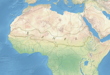
The Sahel region of Africa has long experienced a series of historic droughts, dating back to at least the 17th century. The Sahel region is a climate zone sandwiched between the Sudanian Savanna to the south and the Sahara desert to the north, across West and Central Africa. While the frequency of drought in the region is thought to have increased from the end of the 19th century, three long droughts have had dramatic environmental and societal effects upon the Sahel nations. Famine followed severe droughts in the 1910s, the 1940s, and the 1960s, 1970s and 1980s, although a partial recovery occurred from 1975-80. The most recent drought occurred in 2012.
While at least one particularly severe drought has been confirmed each century since the 17th century, the frequency and severity of recent Sahelian droughts stands out. Famine and dislocation on a massive scale—from 1968 to 1974 and again in the early and mid-1980s—was blamed on two spikes in the severity of the 1960-1980s drought period. [1] From the late 1960s to early 1980s famine killed 100,000 people, left 750,000 dependent on food aid, and affected most of the Sahel's 50 million people. [2] The economies, agriculture, livestock and human populations of much of Mauritania, Mali, Chad, Niger and Burkina Faso (known as Upper Volta during the time of the drought) were severely impacted. As disruptive as the droughts of the late 20th century were, evidence of past droughts recorded in Ghanaian lake sediments suggest that multi-decadal megadroughts were common in West Africa over the past 3,000 years and that several droughts lasted far longer and were far more severe. [3] [4]
Since the 1980s, summer rainfall in the Sahel has been increasing; this has been associated with an increase in vegetation, forming what has been called a 'greening' of the Sahel. The observed increase in rainfall is accounted for by enhancements in the African easterly jet, which is known to induce wet anomalies. A 2011 study found that the positional shifts in the African easterly jet and African easterly waves accompanied the northward migration of the Sahel rainband. [5]
Because the Sahel's rainfall is heavily concentrated in a very small period of the year, the region has been prone to dislocation when droughts have occurred ever since agriculture developed around 5,000 years ago. The Sahel is marked by rainfalls of less than 1,000 millimetres or 40 inches a year, almost all of which occurs in one continuous season, which can run from several weeks to four months.
Despite this vulnerability, the history of drought and famine in the Sahel do not perfectly correlate. While modern scientific climate and rainfall studies have been able to identify trends and even specific periods of drought in the region, oral and written records over the last millennium do not record famine in all places at all times of drought. One 1997 study, in attempting to map long scale rainfall records to historical accounts of famine in Northern Nigeria, concluded that “the most disruptive historical famines occurred when the cumulative deficit of rainfall fell below 1.3 times the standard deviation of long-term mean annual rainfall for a particular place.” [6] The 1982 to 1984 period, for instance, was particularly destructive to the pastoral Fula people of Senegal, Mali and Niger, and the Tuareg of northern Mali and Niger. The populations had not only suffered in the 1968 to 1974 period, but the inability of many to rebuild herds destroyed a decade earlier, along with factors as various as the shift of political power to settled populations with independence in the 1960s, Senegalese-Mauritanian border relations, and Niger's dependence upon falling world uranium prices coinciding in a destructive famine. [7] [8] [9]
Surviving contemporary records of climate in the Sahel begin with early Muslim travellers in the early Medieval Warm Period. These suggest that Sahel rainfall was relatively low in the 7th and 8th centuries and then increased substantially from about 800 AD. [10] There was a decline in rainfall from about 1300 AD, but an increase again around 200 years later.
According to a study of West African drought based on Ghanaian lake sediments (not eyewitness historical accounts) published in the journal Science in April 2009:
The most recent of these [multicentury droughts] occurred between 1400 and 1750 CE (550 to 200 yr B.P.), similar in timing to the Little Ice Age (LIA, 1400 to 1850 CE), a well-known interval when Northern Hemisphere temperatures were cooler than at present. In contrast with earlier studies, which reconstructed wetter conditions in East Africa during this period, evidence from Lake Bosumtwi supports more recent studies suggesting that this interval was dry. Evidence for LIA drought is not restricted to Africa, however. Records from throughout the tropics, including the western Pacific warm pool, the Arabian Sea, continental Asia, and tropical South America all show evidence for dry conditions during this time period. [3]
The first major historically recorded drought in the Sahel occurred around 1640. Based on the reports of European travellers, [11] a major drought after generally wet conditions also took place during the 1680s.
Cycles of several wet decades followed by a drought were to be repeated during the 18th century. Sahelian drought again killed hundreds of thousands of people in the 1740s and 1750s. [12] The 1740s and 1750s was recorded in chronicles of what is today Northern Nigeria, Niger and Mali as the "Great Famine", the worst for at least 200 years prior. It caused massive dislocation of the Sahelian states of the time, but also disrupted the Trans Saharan trade routes to North Africa and Europe. [13]
Around 1790 dry conditions similar to those of the late 20th century set in [10] and continued until around 1870. After that, a very wet period set in for around 25 years, followed by a return to drier conditions. While the drying begun around 1895 and caused its first large famine only in the early 20th century, the 1820s and 1830s saw a 12 to 15-year drought and regional instances of major famine from Senegal to Chad. Historical records suggest this drought caused a large-scale emigration from the Bornu Empire, contributing to its rapid decline in the 19th century. [13] In what is now northern Senegal, the Imamate of Futa Toro was struck by a famine caused by the failure of 1833's rainy season, leading to waves of famine until 1837. [14]
The first rain gauges in the Sahel date from 1898 and they reveal that a major drought in the 1910s, accompanied by large-scale famine, was followed by wet conditions during the 1920s and 1930s, reaching a peak with the very wet year of 1936. The 1940s saw several minor droughts — notably in 1949 — but the 1950s were consistently wet, and expansion of agriculture to feed growing populations characterised this decade. Many have thought this contributed to the severity of the subsequent Sahel droughts.
Burkina Faso, northern Nigeria, southern Niger, far northern Cameroon (near Lake Chad) and central Chad all struggled with dwindling rain fall from the 1960s.
On May 12 and 26,[ clarification needed ] both Mauritania, the Sénégal River Area and neighbouring parts of both Senegal and Mali faced both a drought and famine. [15] [16]
A literature review from the African Journal of Ecology summarized the environmental changes that species faced after the late 20th century droughts, some of which includes (but is not limited to) severe declines in biodiversity and increases in other disturbances, such as fires. [17]
Throughout June to August 2010, famine struck the Sahel. [18] Niger's crops failed to mature in the heat which resulted in famine. 350,000 faced starvation and 1,200,000 were at risk of famine. [19] In Chad, the temperature reached 47.6 °C (117.7 °F) on June 22 in Faya-Largeau, breaking a record set in 1961 at the same location. Niger tied its highest temperature record set in 1998, on also June 22, at 47.1 °C (116.8 °F) in Bilma. That record was broken the next day, on June 23 when Bilma hit 48.2 °C (118.8 °F). The hottest temperature recorded in Sudan was reached on June 25, at 49.6 °C (121.3 °F) in Dongola, breaking a record set in 1987. [20] Niger reported diarrhoea, starvation, gastroenteritis, malnutrition and respiratory diseases killed and sickened many children July 14. The new military junta appealed for international food aid and has taken serious steps to calling overseas help since coming to office in February 2010. [21] On July 26 the heat reached near-record levels over Chad and Niger. [22]
By the middle of 2010, another drought in the western Sahel was predicted by several organisations for 2011 and 2012. [23] [24] [25]
Originally it was believed that the drought in the Sahel primarily was caused by humans over-using natural resources in the region through overgrazing, deforestation [26] and poor land management. [27] [28] In the late 1990s, [29] climate model studies suggested that large scale climate changes were also triggers for the drought.
Based on Senegal river cycles, precipitation cycles of various El Sahel stations which are related to Solar (89–120 years) Wolf-Gleissberg cycles, and on relations to Nile floods and Equatorial lake levels, Yousef and Ghilly in 2000 anticipated that there is a considerable probability that drought will occur El Sahel Zone in 2005±4 years. This forecast was correct as drought occurred in El Niger in 2005 and again in 2010. [30]
In 2002, after the phenomenon of global dimming was discovered, a CSIRO study [31] suggested that the drought was probably caused by air pollution generated in Eurasia and North America, which changed the properties of clouds over the Atlantic Ocean, disturbing the monsoons and shifting the tropical rains southwards.
In 2005, a series of climate modeling studies performed at NOAA / Geophysical Fluid Dynamics Laboratory indicated that the late 20th century Sahel drought was probably a climatic response to changing sea surface temperature patterns, and that it could be viewed as a combination of natural variability superimposed upon an anthropogenically forced regional drying trend. [32] Using GFDL CM2.X, these climate model simulations indicated that the general late 20th century Sahel drying trend was attributable to human-induced factors; largely due to an increase in greenhouse gases and partly due to an increase in atmospheric aerosols. A study published in 2013, done at the University of Washington, suggests that atmospheric aerosols caused a downward shift in the Intertropical Convergence Zone. [33] The shift, the study says, left normally rainy areas in Central Africa much drier. [33] In IPCC future scenario A2 (CO2 value of ≈860 ppm) Sahel rainfall could be reduced by up to 25% by year 2100, according to climate models.
A 2006 study by NOAA scientists suggests that the Atlantic Multidecadal Oscillation plays a leading role. An AMO warm phase strengthens the summer rainfall over Sahel, while a cold phase reduces it. [34] The AMO entered a warm phase in 1995 and, assuming a 70-year cycle (following peaks in ≈1880 and ≈1950), will peak around 2020. [35] A 2009 study found further evidence for a link between the AMO and West African drought. [3] Later, a 2013 study [36] found that the East Atlantic (EA) mode also modulates Sahel summer rainfall and further indicated that operational climate forecasting was unable to capture this EA impact on the Sahel.
The recovery of Sahel drought since the 1990s, coined "Sahel Greening" by media, is accounted for by enhancements in both the tropical easterly jet and the African easterly jet, both of which are known to induce wet anomalies. [5] Moreover, positional shifts in the African easterly jet and African easterly waves (AEWs) accompanied the northward migration of the Sahel rainband. Change in the African easterly jet and AEWs are coupled to a northward shift and amplification of convective activity. [5]
In 1973, The United Nations Sahelian Office (UNSO) was created to address the problems of drought in the Sahel region following the West African Sahel drought of 1968-73. In the 1990s, the United Nations Convention to Combat Desertification (UNCCD) was adopted and UNSO became the United Nations Development Programme's Office to Combat Desertification and Drought, as its scope broadened to be global rather than only focused on Africa. [37]
Chad is one of the 47 landlocked countries in the world and is located in North Central Africa, measuring 1,284,000 square kilometers (495,755 sq mi), nearly twice the size of France and slightly more than three times the size of California. Most of its ethnically and linguistically diverse population lives in the south, with densities ranging from 54 persons per square kilometer in the Logone River basin to 0.1 persons in the northern B.E.T. (Borkou-Ennedi-Tibesti) desert region, which itself is larger than France. The capital city of N'Djaména, situated at the confluence of the Chari and Logone Rivers, is cosmopolitan in nature, with a current population in excess of 700,000 people.
Desertification is a type of land degradation in drylands in which biological productivity is lost due to natural processes or induced by human activities whereby fertile areas become arid. It is the spread of arid areas caused by a variety of factors, such as climate change and overexploitation of soil as a result of human activity.
Niger is a landlocked nation in West Africa located along the border between the Sahara and Sub-Saharan regions. Its geographic coordinates are longitude 16°N and latitude 8°E. Its area is 1.267 million square kilometers, of which 1 266 700 km2 is land and 300 km2 water, making Niger slightly less than twice the size of France.
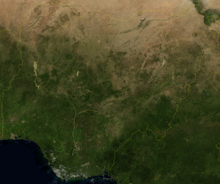
Nigeria is a country in West Africa, it shares land borders with the Republic of Benin to the west, Chad and Cameroon to the east, and Niger to the north. Its coast lies on the Gulf of Guinea in the south and it borders Lake Chad to the northeast. Notable geographical features in Nigeria include the Adamawa Plateau, Mambilla Plateau, Jos Plateau, Obudu Plateau, the Niger River, Benue River, and Niger Delta.
Senegal is a coastal West African nation located 14 degrees north of the equator and 14 degrees west of the Prime Meridian. The country's total area is 196,190 km2 of which 192,000 km2 is land and 4,190 km2 is water.
A drought is defined as drier than normal conditions. This means that a drought is "a moisture deficit relative to the average water availability at a given location and season". A drought can last for days, months or years. Drought often exerts substantial impacts on the ecosystems and agriculture of affected regions, and causes harm to the local economy. Annual dry seasons in the tropics significantly increase the chances of a drought developing and subsequent wildfires. Periods of heat can significantly worsen drought conditions by hastening evaporation of water vapour.
Mauritania, a country in the western region of the continent of Africa, is generally flat, its 1,030,700 square kilometres forming vast, arid plains broken by occasional ridges and clifflike outcroppings. Mauritania is the world’s largest country lying entirely below an altitude of 1,000 metres (3,300 ft). It borders the North Atlantic Ocean, between Senegal and Western Sahara, Mali and Algeria. It is considered part of both the Sahel and the Maghreb. A series of scarps face southwest, longitudinally bisecting these plains in the center of the country. The scarps also separate a series of sandstone plateaus, the highest of which is the Adrar Plateau, reaching an elevation of 500 metres or 1,640 feet. Spring-fed oases lie at the foot of some of the scarps. Isolated peaks, often rich in minerals, rise above the plateaus; the smaller peaks are called Guelbs and the larger ones Kedias. The concentric Guelb er Richat is a prominent feature of the north-central region. Kediet ej Jill, near the city of Zouîrât, has an elevation of 915 metres or 3,002 feet and is the highest peak.
Mali is a landlocked nation in West Africa, located southwest of Algeria, extending south-west from the southern Sahara Desert through the Sahel to the Sudanian savanna zone. Mali's size is 1,240,192 square kilometers.
West Africa or Western Africa is the westernmost region of Africa. The United Nations defines Western Africa as the 16 countries of Benin, Burkina Faso, Cape Verde, The Gambia, Ghana, Guinea, Guinea-Bissau, Ivory Coast, Liberia, Mali, Mauritania, Niger, Nigeria, Senegal, Sierra Leone, and Togo, as well as Saint Helena, Ascension and Tristan da Cunha. The population of West Africa is estimated at 419 million people as of 2021, and at 381,981,000 as of 2017, of which 189,672,000 were female and 192,309,000 male. The region is demographically and economically one of the fastest growing on the African continent.
The Sahel is a region in Africa. It is defined as the ecoclimatic and biogeographic realm of transition between the Sahara to the north and the Sudanian savanna to the south. Having a hot semi-arid climate, it stretches across the south-central latitudes of Northern Africa between the Atlantic Ocean and the Red Sea.
Sudan is the geographical region to the south of the Sahara, stretching from Western Africa to Central and Eastern Africa. The name derives from the Arabic bilād as-sūdān, or "the lands of the Blacks", referring to West Africa and northern Central Africa.
The Permanent Interstate Committee for Drought Control in the Sahel is an international organization consisting of countries in the Sahel region of Africa.
The Ferlo Desert, also known as the Ferio Desert, is a desert in northern-central Senegal. It is inhabited by the Serer and the Fulani.
Farmer-managed natural regeneration (FMNR) is a low-cost, sustainable land restoration technique used to combat poverty and hunger amongst poor subsistence farmers in developing countries by increasing food and timber production, and resilience to climate extremes. It involves the systematic regeneration and management of trees and shrubs from tree stumps, roots and seeds. FMNR was developed by the Australian agricultural economist Tony Rinaudo in the 1980s in West Africa. The background and development are described in Rinaudo's book The Forest Underground.
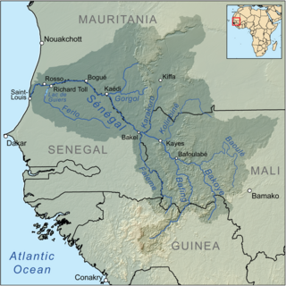
A large-scale, drought-induced famine occurred in Africa's Sahel region and many parts of the neighbouring Sénégal River Area from February to August 2010. It is one of many famines to have hit the region in recent times.
Michael Mortimore was a British geographer and a prolific researcher of issues in the African drylands. He was an academic in Nigerian universities for over 25 years. He ran a British research consultancy, Drylands Research. He is best known for an anti-Malthusian account of population-environment relationships, More People, Less Erosion, and field-based studies of adaptation to drought.
Climate change in Africa is an increasingly serious threat in Africa which is among the most vulnerable continents to the effects of climate change. Some sources even classify Africa as "the most vulnerable continent on Earth". This vulnerability is driven by a range of factors that include weak adaptive capacity, high dependence on ecosystem goods for livelihoods, and less developed agricultural production systems. The risks of climate change on agricultural production, food security, water resources and ecosystem services will likely have increasingly severe consequences on lives and sustainable development prospects in Africa. With high confidence, it was projected by the IPCC in 2007 that in many African countries and regions, agricultural production and food security would probably be severely compromised by climate change and climate variability. Managing this risk requires an integration of mitigation and adaptation strategies in the management of ecosystem goods and services, and the agriculture production systems in Africa.
2012 had a very severe drought in the Sahel, the semiarid region of Africa that lies between the Sahara and the savannas. Countries included in this region are Senegal, Mauritania, Mali, Burkina Faso, Niger, Nigeria, Chad, Sudan, and Eritrea. Droughts in the Sahel occur quite often and tend to reduce the already meager water supply and stress the economies of developing countries in that region.
Climate change in Senegal will have wide reaching impacts on many aspects of life in Senegal. Climate change will cause an increase in average temperatures over west Africa by between 1.5 and 4 °C by mid-century, relative to 1986–2005. Projections of rainfall indicate an overall decrease in rainfall and an increase in intense mega-storm events over the Sahel. The sea level is expected to rise faster in West Africa than the global average. Although Senegal is currently not a major contributor to global greenhouse gas emissions, it is one of the most vulnerable countries to climate change.
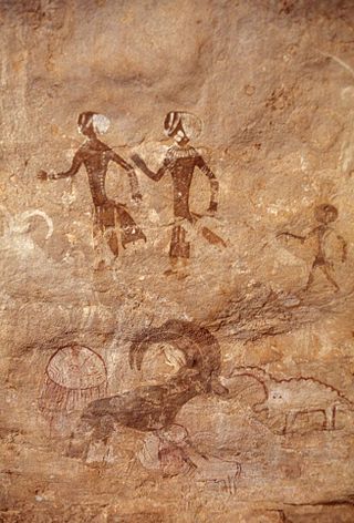
The prehistory of West Africa spans from the earliest human presence in the region until the emergence of the Iron Age in West Africa. West African populations were considerably mobile and interacted with one another throughout the population history of West Africa. Acheulean tool-using archaic humans may have dwelled throughout West Africa since at least between 780,000 BP and 126,000 BP. During the Pleistocene, Middle Stone Age peoples, who dwelled throughout West Africa between MIS 4 and MIS 2, were gradually replaced by incoming Late Stone Age peoples, who migrated into West Africa as an increase in humid conditions resulted in the subsequent expansion of the West African forest. West African hunter-gatherers occupied western Central Africa earlier than 32,000 BP, dwelled throughout coastal West Africa by 12,000 BP, and migrated northward between 12,000 BP and 8000 BP as far as Mali, Burkina Faso, and Mauritania.