Bilma

Last updated

Bilma
Commune
Erg of bilma.png
Niger location map.svg
Red pog.svg
Bilma
Coordinates: 18°41′12″N12°55′09″E / 18.68667°N 12.91917°E / 18.68667; 12.91917
CountryFlag of Niger.svg  Niger
Region Agadez Region
Department Bilma Department
Commune Bilma
Elevation
358 m (1,175 ft)
Population
 (2012 census)
  Total4,016

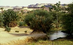
Bilma is an oasis town and commune in north east Niger with, as of the 2012 census, a total population of 4,016 people. [1] It lies protected from the desert dunes under the Kaouar Cliffs and is the largest town along the Kaouar escarpment. It is known for its gardens, for salt and natron production through evaporation ponds, [2] date cultivation, and as the destination of one of the last Saharan caravan routes (the Azalai, from Agadez).

Contents

Population

Its population is mostly Kanuri, with smaller Toubou, Tuareg, and Hausa populations, the last being a reminder of Bilma's role as a key stop in the Trans Saharan trade.

Administration and economy

Bilma is the administrative seat of the Bilma Department, covering some 670,000 km2 (260,000 sq mi) of north eastern Niger. While it continues to produce salt in large natron salt pans, and this salt is still sold for livestock use throughout west Africa. Tourism (based out of Agadez and the Aïr Mountains some 560 km (350 mi) to the west) is of growing importance.

Climate

Bilma features a hot desert climate (Köppen climate classification BWh). The town lies deep in the heart of the Sahara Desert, more precisely in the Ténéré, a hyper-arid desert region lying over northeastern Niger and western Chad, and as such is extremely dry, averaging only 12.7 mm (0.50 in) of measurable precipitation annually. Bilma is also hot during the "winter" months and extremely hot during the summer months and for prolonged periods of time. Average high temperatures in "winter" months surpass 27 °C (81 °F), and exceed 40 °C (104 °F) from April to September inclusively, peaking at 44 °C (111 °F) in June. The record high temperature is 48.2 °C (118.8 °F) on June 23, 2010. [3]

Bilma had the country's lowest ever recorded temperature, −2.4 °C (27.7 °F), on 13 January 1995. [4] [5]

The sunshine duration is extremely high year-round with some 4,000 h of bright sunshine annually. The region excels at hot, sunny and dry weather.

Climate data for Bilma, Niger
MonthJanFebMarAprMayJunJulAugSepOctNovDecYear
Average high °C (°F)27.7
(81.9)
31.9
(89.4)
35.3
(95.5)
40.6
(105.1)
42.9
(109.2)
44.1
(111.4)
43.0
(109.4)
42.1
(107.8)
41.8
(107.2)
39.1
(102.4)
33.1
(91.6)
28.7
(83.7)
37.5
(99.6)
Daily mean °C (°F)18.2
(64.8)
21.7
(71.1)
24.9
(76.8)
30.4
(86.7)
33.5
(92.3)
34.7
(94.5)
34.3
(93.7)
34.4
(93.9)
32.7
(90.9)
29.3
(84.7)
22.7
(72.9)
18.5
(65.3)
27.9
(82.3)
Average low °C (°F)8.7
(47.7)
11.4
(52.5)
14.5
(58.1)
20.1
(68.2)
24.1
(75.4)
25.3
(77.5)
25.5
(77.9)
26.6
(79.9)
23.6
(74.5)
19.5
(67.1)
12.2
(54.0)
8.3
(46.9)
18.3
(65.0)
Average precipitation mm (inches)0.00
(0.00)
0.00
(0.00)
0.00
(0.00)
0.00
(0.00)
0.00
(0.00)
0.00
(0.00)
2.5
(0.10)
7.6
(0.30)
2.5
(0.10)
0.00
(0.00)
0.00
(0.00)
0.00
(0.00)
13
(0.50)
Source: Niger Climatology [6]
The Oasis at Bilma, with the Kaouar escarpment in the background. Oasis-Bilma.jpg
The Oasis at Bilma, with the Kaouar escarpment in the background.
The saline pans at Bilma. Bilma-Saline-85.jpg
The saline pans at Bilma.

History

The poet Abu Ishaq Ibrahim al-Kanemi was born in Bilma in the 12th century.

The isolation of Bilma made it the destination for disgraced officials under the authoritarian regime of Seyni Kountché, and a prison was built there by the government. Political leaders were held there in the 1980s, such as Sanoussi Tambari Djakou, today president of the PNA-AL, a Nigerien political party. During French Colonial rule, Bilma was the site of a major—if isolated—military post at Fort Dromard.

In 1989, UTA Flight 772 crashed into the desert near the town after a bomb exploded on board.

Related Research Articles

<span class="mw-page-title-main">Geography of Niger</span> Geographic feature of Niger

Niger is a landlocked nation in West Africa located along the border between the Sahara and Sub-Saharan regions. Its geographic coordinates are longitude 16°N and latitude 8°E. Its area is 1.267 million square kilometers, of which 1 266 700 km2 is land and 300 km2 water, making Niger slightly less than twice the size of France.

<span class="mw-page-title-main">Geography of Mali</span> Overview of the geography of Mali

Mali is a landlocked nation in West Africa, located southwest of Algeria, extending south-west from the southern Sahara Desert through the Sahel to the Sudanian savanna zone. Mali's size is 1,240,192 square kilometers.

<span class="mw-page-title-main">Sahel</span> Ecoclimatic and biogeographic transition zone in Africa

The Sahel is a region in Africa. It is defined as the ecoclimatic and biogeographic realm of transition between the Sahara to the north and the Sudanian savanna to the south. Having a hot semi-arid climate, it stretches across the south-central latitudes of Northern Africa between the Atlantic Ocean and the Red Sea.

<span class="mw-page-title-main">Sahara</span> Desert on the African continent

The Sahara is a desert on the African continent. With an area of 9,200,000 square kilometres (3,600,000 sq mi), it is the largest hot desert in the world and the third-largest desert overall, smaller only than the deserts of Antarctica and the northern Arctic.

<span class="mw-page-title-main">Agadez</span> City in Agadez Region, Niger

Agadez, formerly spelled Agadès, is the fifth largest city in Niger, with a population of 110,497 based on the 2012 census. The capital of Agadez Region, it lies in the Sahara desert, and is also the capital of Aïr, one of the traditional Tuareg–Berber federations. The historic centre of the town has been designated a World Heritage Site by UNESCO.

<span class="mw-page-title-main">Ténéré</span> Desert in Niger and Chad

The Ténéré is a desert region in south central Sahara. It comprises a vast plain of sand stretching from northeastern Niger into western Chad, occupying an area of over 400,000 square kilometres (150,000 sq mi). The Ténéré's boundaries are said to be the Aïr Mountains in the west, the Hoggar Mountains in the north, the Djado Plateau in the northeast, the Tibesti Mountains in the east, and the basin of Lake Chad in the south. The central part of the desert, the Erg du Bilma, is centred at approximately 17°35′N10°55′E. It is the locus of the Neolithic Tenerian culture.

<span class="mw-page-title-main">Timia</span> Commune and town in Agadez Region, Niger

Timia is a small town and commune in northern Niger, situated at an oasis in the Aïr Mountains, Agadez Region, Arlit Department. Visitors come to the Tuareg town to see a seasonal waterfall, a former French fort and the nearby ruined town of Assodé. As of 2011, the commune had a total population of 13,588 people.

<span class="mw-page-title-main">Trans-Saharan trade</span> Trade between Africa and the Mediterranean

Trans-Saharan trade requires travel across the Sahara between sub-Saharan Africa and North Africa. While existing from prehistoric times, the peak of trade extended from the 8th century until the early 17th century. The Sahara once had a very different environment. In Libya and Algeria, from at least 7000 BC, there was pastoralism, the herding of sheep, goats, large settlements, and pottery. Cattle were introduced to the Central Sahara (Ahaggar) from 4000 to 3500 BC. Remarkable rock paintings in places that are currently very dry, portray flora and fauna that are not present in the modern desert environment.

<span class="mw-page-title-main">Ubari</span> Town in Fezzan, Libya

Ubari or Awbari is a Tuareg Berber–speaking oasis town and the capital of the Wadi al Hayaa District, in the Fezzan region of southwestern Libya. It is in the Idehan Ubari, a Libyan section of the Sahara Desert. It was the capital of the former baladiyah (district) called Awbari, in the southwest of the country.

<span class="mw-page-title-main">Azalai</span>

The Azalai is a semi-annual salt caravan route practiced by Tuareg traders in the Sahara desert between Timbuktu and the Taoudenni salt mine in Mali, or the act of traveling with a caravan along that route.

<span class="mw-page-title-main">Agadez Region</span> Region of Niger

Agadez Region is one of the seven regions of Niger. At 667,799 square kilometres (257,839 sq mi), it covers more than half of Niger's land area, and is the largest region in the country, as well as the largest African state subdivision. The capital of the department is Agadez.

<span class="mw-page-title-main">Tindouf</span> Commune and town in Algeria

Tindouf is the main town, and a commune in Tindouf Province, Algeria, close to the Mauritanian, Western Saharan and Moroccan borders. The commune has population of around 160,000 but the census and population estimates do not count the Sahrawi refugees making the population as of the 2008 census 45,966, up from 25,266 in 1998, and an annual population growth rate of 6.3%.

In-Gall is a town in the Agadez Region, Tchirozerine Department of northeast Niger, with a year-round population of less than 500. Known for its oasis and salt flats, In-Gall is the gathering point for the Cure Salee festival of Tuareg and Wodaabe pastoralists to celebrate the end of the rainy season each September. During the festival, In-Gall's population grows to several thousand nomads, officials, and tourists. As of 2011, the commune had a total population of 47,170 people.

<span class="mw-page-title-main">Kaouar</span>

The Kaouar is a series of ten oases in the southern Sahara in northeast Niger, covering about 75 km (50 mi) from north to south, and 1–5 km (0.62–3.11 mi) east to west. They are on the eastern edge of the Ténéré desert, between the Tibesti Mountains in the east and the Aïr Mountains in the west and between the Fezzan in the north and Lake Chad in the south. They lie on the leeward side of a 100-meter-high north–south escarpment and easterly winds striking the escarpment provide easy access to groundwater for the oases.

<span class="mw-page-title-main">Fachi</span> Commune in Agadez Region, Niger

Fachi is an oasis surrounded by the Ténéré desert and the dunes of the Erg of Bilma in eastern Niger, placed on the western edge of the small Agram mountain outcropping. It has an estimated population of 2,000 people. It is also a stopping point of the Agadez to the Kaouar caravans of the Azalay. Fachi is 240 kilometres west of Bilma and 320 km (200 mi) east of the Aïr Mountains. Apart from water, dates, and salt, Fachi produces no provisions, and depends entirely upon trade in these products with passing caravans.

<span class="mw-page-title-main">Bilma Department</span> Department in Agadez Region, Niger

Bilma is a department of the Agadez Region in Niger. Its capital lies at the city of Bilma. As of 2012, the department had a total population of 17,935 people.

<span class="mw-page-title-main">Dirkou</span> Commune in Agadez Region, Niger

Dirkou is a town in the Bilma Department, Agadez Region of north-eastern Niger. It lies in the northern Kaouar escarpment, a north–south line of cliffs which form an isolated oasis in the Sahara desert. As of 2011, the commune had a total population of 14,998 people. Apart from the main city of Dirkou, the rural communities of Achénouma, Aney, and Emi Tchouma lie within the borders of the commune.

<span class="mw-page-title-main">Séguedine</span> Commune in Agadez Region, Niger

Séguédine is a town in central eastern Niger, lying at the far northern tip of the Kaouar escarpment, an inhabited oasis in the midst of the Sahara Desert. It is a Commune of Bilma Department, Agadez Region.

Achénouma, also spelled Achinouma, is an administrative village located in Agadez Region, Niger. Achénouma is not one of Niger's 255 communes, and is geographically located within the commune of Dirkou.

Djado is a ghost town in Bilma in Niger. The settlement lies on the plateau with the same name. The settlement likely wasn't called Djado during its existence. The site is quite remote. No excavation has been done, so the real name of the settlement is unknown.

References

  1. "Annuaires_Statistiques" (PDF). Institut National de la Statistique du Niger . Retrieved 2 May 2013.
  2. Lovejoy, Paul E. (1986). Salt of the Desert Sun: A History of Salt Production and Trade in the Central Sudan. Cambridge University Press. ISBN   0-521-30182-3.
  3. "Dr. Jeff Masters' WunderBlog". Wayback Machine. 16 July 2010. Archived from the original on 19 July 2010. Retrieved 25 November 2020.
  4. "Troisieme Communication Nationale A La Conference Des Parties De La Conventioncadre Des Nations Unies Sur Les Changements Climatiques" (PDF). Archived from the original (PDF) on 6 May 2018. Retrieved 25 July 2020.
  5. Geographic.org. "Weather data: Niger, Bilma, 1995, January". Historical Global Weather. Retrieved 25 July 2020.
  6. "Niger Climatology" (PDF). Stats-Niger. Retrieved 14 April 2012.

Sources

18°41′N12°55′E / 18.683°N 12.917°E / 18.683; 12.917