
Madaoua is a town and urban commune located in the Tahoua Region of Niger. It has a population of 127,254. It is seat of the Madaoua Department, forming the southwest corner of the Region, and is an Urban Commune.
Mayahi is a town located in the Maradi Region of Niger. It is the seat of Mayahi Department and a Commune about 45 km from Tessaoua. In 2012 it had a population of 14,000 in the urban area. The name "Mayaki" is also a rulers' title among the Sudié and Maouri: local subgroups of the Hausa people.

The Departments of Niger are subdivided into communes. As of 2005, in the seven Regions and one Capital Area, there were 36 départements, divided into 265 communes, 122 cantons and 81 groupements. The latter two categories cover all areas not covered by Urban Communes or Rural Communes, and are governed by the Department, whereas Communes have elected councils and mayors. Additional semi-autonomous sub-divisions include Sultanates, Provinces and Tribes (tribus). The Nigerien government estimates there are an additional 17000 Villages administered by Rural Communes, while there are over 100 Quartiers administered by Urban Communes.
Dabaga is a town and rural commune in the Agadez Region of northern Niger. The town is situated around 50 kilometers north of the regional capital, Agadez, on the main road leading north into the Aïr Mountains and the town of Elmeki. Like the nearby communities of Azel, Elmeki and Egandawel, Dabaga is an oasis in the Aïr Massif valleys, populated by both sedentary and semi-nomadic Tuaregs and small numbers of Hausa and other groups. According to the census 2012, Dabaga had a permanent population of 23,969, mostly families of Tuareg pastoralists, where the adult males traveled with their herds.
Tchirozerine is a town and urban commune in Niger. As of 2012, the commune's population was 63,503.
Azarori is a village and rural commune in Niger.
Bankilaré is a village and rural commune in Niger. Bankilaré commune, centered on the town of the same name, is in Téra Department, Tillabéri Region, in the northwestern corner of the country. The town lies 60 km north of Departmental capital Téra, and around the same distance from the Burkina Faso border and the Mali border. As of 2012, it had a population of 84,893.
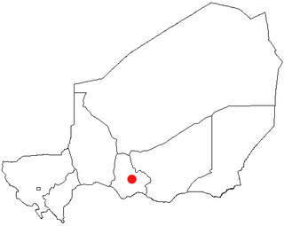
Garhanga is a village and rural commune in Niger. It is located in the Keita Department of the Tahoua region. As of 2012, it has a population of 69,712.
Kolleram is a village and rural commune in the Mirriah Department of the Zinder Region of Niger. As of 2012, it had a population of 29,583.
Sanam is a village and rural commune in Niger.
Tabelot is a village and rural commune in central Niger. As of 2011, the commune had a total population of 32,431 people.
Tamaske is a city and rural commune in Niger. It is located in the Keita Department, in the Tahoua Region.
Tamou is a village and "Rural commune" in Niger. The town is capital of its Rural Commune in the Say Department of Tillabéri Region, in the far southwest of the nation. It is southwest of Niamey, on the right (western) bank of the Niger River, between the departmental capital Say and the border of Burkina Faso. Tamou Commune is home to the Tamou Total Reserve, a wildlife reserve which is part of the larger W National Park and Transborder Reserve. The Tamou Reserve, in which local people also live, is primarily dedicated to the protection of African Elephant populations which migrate through the region.
Tarka, Niger is a village and rural commune in Niger. It is located in the Belbédji Departement of the Zinder Region. As of 2012 the commune had a population of 96,452.

Tassara is a village and rural commune in Niger.

Tesker or Tasker is a village and rural commune in Niger. As of 2012, it had a population of 37,132 people. It is the birthplace of musician Mamane Barka . The sparsely populated commune extends over a wide area and spans two major regions: the Sahel region in the south and the Sahara desert in the north. In the northeast, it rises up to a height of 710 metres (2,330 ft) at the Termit Massif. It is bordered by Fachi and Tabelot in the north, N'Gourti to the east, Alakoss, Kellé and N'Guelbély to the south and Tenhya to the west. The municipality is divided into 36 administrative villages, one traditional village, three hamlets, 29 camps and 144 watering places.
Tondikandia is a rural commune in Filingué Department, Tillabéri Region, Niger. Its chief place and administrative center is the town of Damana.
Torodi is a small town and a rural commune in Niger. As of 2012, it had a population of 109,342. As a rural center, Torodi hosts a large weekly market and the seat of local tribal authority (canton). Torodi is in the Say Department of the Tillaberi Region, which surrounds the national capital, Niamey. Say Department, with its capital at the large Niger River town of Say, abuts Niamey to the southwest and across the river to the west. The town of Torodi lies about 60 km due west of the city of Say and 50 km east of the border with Burkina Faso. Torodi itself lies on a tributary of the Niger, the Gourbi river.
Yaouri is a village and rural commune in Matameye Department in Niger.
Youri, Niger is a village and rural commune in Niger. As of 2012, it had a population of 31,598.
