Niger is a landlocked nation in West Africa located along the border between the Sahara and Sub-Saharan regions. Its geographic coordinates are longitude 16°N and latitude 8°E. Its area is 1.267 million square kilometers, of which 1 266 700 km2 is land and 300 km2 water, making Niger slightly less than twice the size of France.
The Aïr Mountains or Aïr Massif is a triangular massif, located in northern Niger, within the Sahara. Part of the West Saharan montane xeric woodlands ecoregion, they rise to more than 1,800 m (5,900 ft) and extend over 84,000 km2 (32,000 sq mi). Lying in the midst of desert north of the 17th parallel, the Aïr plateau, with an average altitude between 500 and 900 m, forms an island of Sahel climate which supports a wide variety of life, many pastoral and farming communities, and dramatic geological and archaeological sites. There are notable archaeological excavations in the region that illustrate the prehistoric past of this region. The endangered African wild dog once existed in this region, but may now be extirpated due to human population pressures in this region.

Agadez, formerly spelled Agadès, is the fifth largest city in Niger, with a population of 110,497 based on the 2012 census. The capital of Agadez Region, it lies in the Sahara desert, and is also the capital of Aïr, one of the traditional Tuareg–Berber federations. The historic centre of the town has been designated a World Heritage Site by UNESCO.

N'guigmi is a city and Commune of fifteen thousand in the easternmost part of Niger, very near to Lake Chad – lying on its shore until the lake retreated. It is a crossroads for the traditional camel caravans of the Toureg and for traders plying North and South across the Sahara.
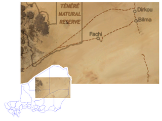
Bilma is an oasis town and commune in north east Niger with, as of the 2012 census, a total population of 4,016 people. It lies protected from the desert dunes under the Kaouar Cliffs and is the largest town along the Kaouar escarpment. It is known for its gardens, for salt and natron production through evaporation ponds, date cultivation, and as the destination of one of the last Saharan caravan routes.

Agadez Region is one of the seven regions of Niger. At 667,799 square kilometres (257,839 sq mi), it covers more than half of Niger's land area, and is the largest region in the country, as well as the largest African state subdivision. The capital of the department is Agadez.

Tahoua is one of eight Regions of Niger. The capital of the region is the commune of Tahoua. The region covers 106,677 km².

Abalak is a town located in the Tahoua Region, Abalak Department of northern Niger. It is both a town and Commune: a local administrative division. It is the seat (Chef-lieu) of Abalak Department, one of eight subdivisions of Tahoua Region. The town had a population of less than 74,719 at the 2012 census.
In-Gall is a town in the Agadez Region, Tchirozerine Department of northeast Niger, with a year-round population of less than 500. Known for its oasis and salt flats, In-Gall is the gathering point for the Cure Salee festival of Tuareg and Wodaabe pastoralists to celebrate the end of the rainy season each September. During the festival, In-Gall's population grows to several thousand nomads, officials, and tourists. As of 2011, the commune had a total population of 47,170 people.

The Departments of Niger are subdivided into communes. As of 2005, in the seven Regions and one Capital Area, there were 36 départements, divided into 265 communes, 122 cantons and 81 groupements. The latter two categories cover all areas not covered by Urban Communes or Rural Communes, and are governed by the Department, whereas Communes have elected councils and mayors. Additional semi-autonomous sub-divisions include Sultanates, Provinces and Tribes (tribus). The Nigerien government estimates there are an additional 17000 Villages administered by Rural Communes, while there are over 100 Quartiers administered by Urban Communes.

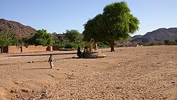
Aouderas is an oasis village in the Aïr Mountains of northeastern Niger, about 90 km (56 mi) north-northeast of the regional capital of Agadez. It is also the name of the valley in which the town is located.
Iferouane, also spelled Iferouan, is an oasis town and commune in northern Niger, in Agadez Department. It is located northeast of Arlit in the northern Aïr, in the Ighazar valley near the Tamgak Range.
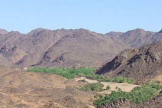
Dabaga is a town and rural commune in the Agadez Region of northern Niger. The town is situated around 50 kilometers north of the regional capital, Agadez, on the main road leading north into the Aïr Mountains and the town of Elmeki. Like the nearby communities of Azel, Elmeki and Egandawel, Dabaga is an oasis in the Aïr Massif valleys, populated by both sedentary and semi-nomadic Tuaregs and small numbers of Hausa and other groups. According to the census 2012, Dabaga had a permanent population of 23,969, mostly families of Tuareg pastoralists, where the adult males traveled with their herds.
Arlit is a department of the Agadez Region in Niger. Its capital lies at the city of Arlit. As of 2012, the department had a total population of 105,025 people.

Tchirozerine is a department of the Agadez Region in Niger. Its capital lies at the city of Tchirozerine. As of 2011, the department had a total population of 328,018 people.
Akoubounou, or Akabinu in the local Tin Sert language, is a village located in the west to the town of Abalak, in the Tahoua Region of Niger.
Dirkou is a town in the Bilma Department, Agadez Region of north-eastern Niger. It lies in the northern Kaouar escarpment, a north–south line of cliffs which form an isolated oasis in the Sahara desert. As of 2011, the commune had a total population of 14,998 people. Apart from the main city of Dirkou, the rural communities of Achénouma, Aney, and Emi Tchouma lie within the borders of the commune.
Séguédine is a town in central eastern Niger, lying at the far northern tip of the Kaouar escarpment, an inhabited oasis in the midst of the Sahara Desert. It is a Commune of Bilma Department, Agadez Region.
Garhanga is a village and rural commune in Niger. It is located in the Keita Department of the Tahoua region. As of 2012, it has a population of 69,712.
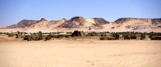
Djado is a ghost town in Bilma in Niger. The settlement lies on the plateau with the same name. The settlement likely wasn't called Djado during its existence. The site is quite remote. No excavation has been done, so the real name of the settlement is unknown.