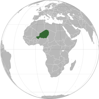
Niger or the Niger, officially the Republic of the Niger, is a landlocked country in West Africa. It is a unitary state bordered by Libya to the northeast, Chad to the east, Nigeria to the south, Benin and Burkina Faso to the southwest, Mali to the west, and Algeria to the northwest. It covers a land area of almost 1,270,000 km2 (490,000 sq mi), making it the largest landlocked country in West Africa. Over 80% of its land area lies in the Sahara. Its predominantly Muslim population of about 25 million lives mostly in clusters in the south and west of the country. The capital Niamey is located in Niger's southwest corner.

The regions of Niger are subdivided into 63 departments. Before the devolution program on 1999–2005, these departments were styled arrondissements. Confusingly, the next level up (regions) had, before 2002-2005 been styled departments. Prior to a revision in 2011, there had been 36 departments. A draft law in August 2011 would expand that number to 63. Until 2010, arrondissements remained a proposed subdivision of departments, though none were used. The decentralisation process, begun in the 1995-1999 period replaced appointed Prefects at Departmental or Arrondissement level with elected councils, first elected in 1999. These were the first local elections held in the history of Niger. Officials elected at commune level are then selected as representatives at Departmental, regional, and National level councils and administration. The Ministry of Decentralisation was created to oversee this task, and to create a national consultative council of local officials.

Maradi is the second largest city in Niger and the administrative centre of Maradi Region. It is also the seat of the Maradi Department and an Urban Commune.
Zinder Region is one of the seven regions of Niger; the capital of the region is Zinder. The region covers 145,430 km². It is the most populous province of Niger.

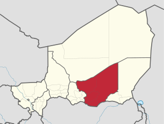
The Region of Maradi is one of seven regions of Niger. It is located in south-central Niger, east of the Region of Tahoua, west of Zinder, and north of the Nigerian city of Katsina. The administrative centre is at Maradi. The population of the Region is predominantly Hausa.
The Departments of Niger are subdivided into communes. As of 2005, in the seven Regions and one Capital Area, there were 36 départements, divided into 265 communes, 122 cantons and 81 groupements. The latter two categories cover all areas not covered by Urban Communes or Rural Communes, and are governed by the Department, whereas Communes have elected councils and mayors. Additional semi-autonomous sub-divisions include Sultanates, Provinces and Tribes (tribus). The Nigerien government estimates there are an additional 17000 Villages administered by Rural Communes, while there are over 100 Quartiers administered by Urban Communes.
Bouza is a town in southwestern Niger. A town of eight thousand, it is the administrative center of Bouza Department, part of Tahoua Region.
Goure is a town in southeastern Niger, Zinder Region, Goure Department, of which it is the seat.

Abdou Moumouni University, formerly the University of Niamey from 1974 to 1994, is a public university based in Niamey, the capital of Niger. The main campus is situated on the right bank of the Niger River. Historically, its students and faculty have been involved in protest movements in the capital.

The Goulbi de Maradi is a river in south central Niger and north central Nigeria. Between its source near Katsina in Nigeria, and its end in the Rima River, the Goulbi de Maradi never flows more than 48 kilometres (30 mi) from the Niger–Nigeria border. Though important for agriculture and pastoralism, and flowing through the Niger cities of Maradi, Guidan Roumdji, and Madarounfa, the Goulbi de Maradi is a seasonal river and flows only during the rainy season.
Dabaga is a town and rural commune in the Agadez Region of northern Niger. The town is situated around 50 kilometers north of the regional capital, Agadez, on the main road leading north into the Aïr Mountains and the town of Elmeki. Like the nearby communities of Azel, Elmeki and Egandawel, Dabaga is an oasis in the Aïr Massif valleys, populated by both sedentary and semi-nomadic Tuaregs and small numbers of Hausa and other groups. According to UNICEF, Dabaga had a permanent population of 35,000 in early 2007, mostly families of Tuareg pastoralists, where the adult males traveled with their herds.
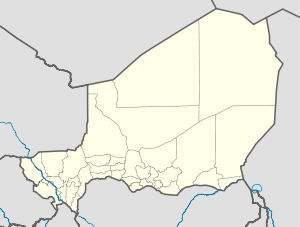
Niger is divided into seven regions, each of which is named after its capital. Additionally, the national capital, Niamey, comprises a capital district.

Aguie is a department of the Maradi Region in Niger. Its capital lies at the city of Aguie. Among the commune subdivisions within the Department are the "Rural Communes" of Saé Saboua, Arnagou and Giratawa. Nearby villages include Dan Kiri, Dan Gao, Gamji Karama, Dan Rago, Doromawa, Guidan Tonio, and Guidan Kodao.

Bouza is a department of the Tahoua Region in Niger. Its capital lies at the city of Bouza, and also includes the town of Déoulé. As of 2011, the department had a total population of 386,093 people.
The government of Niger is the apparatus through which authority functions and is exercised: the governing apparatus of Nigerien state. The current system of governance, since the Constitution of 25 November 2010, is termed the Seventh Republic of Niger. It is a semi-presidential republic, whereby the President of Niger is head of state and the Prime Minister of Niger head of government. The officials holding these posts are chosen through a representative democratic process of national and local elections, in the context of a competing multi-party system. Executive power is exercised by the government. Legislative power is vested in both the government and the National Assembly. The judiciary is independent of the executive and the legislature: its Constitutional Court has jurisdiction over constitutional and electoral matters.

Niger is governed through a four layer, semi-decentralised series of administrative divisions. Begun 1992, and finally approved with the formation of the Fifth Republic of Niger on 18 July 1999, Niger has been enacting a plan for decentralisation of some state powers to local bodies. Prior to the 1999-2006 project, Niger's subdivisions were administered via direct appointment from the central government in Niamey. Beginning with Niger's first municipal elections of 2 February 1999, the nation started electing local officials for the first time. Citizens now elect local committee representatives in each commune, chosen by subdivisions of the commune: "quarters" in towns and "villages" in rural areas, with additional groupings for traditional polities and nomadic populations. These officials choose mayors, and from them are drawn representatives to the department level. The departmental council, prefect, and representatives to the regional level are chosen here using the same procedure. The system is repeated a regional level, with a regional prefect, council, and representatives to the High Council of Territorial Collectives. The HCCT has only advisory powers, but its members have some financial, planning, educational and environmental powers. The central government oversees this process through the office of the Minister of State for the Interior, Public Safety and Decentralization.
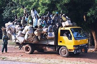
Seasonal migration, locally called the Exode, plays an important part of the economic and cultural life of the West African nation of Niger. While it is a common practice in many nations, Niger sees as much as a third of its rural population travel for seasonal labour, during the Sahelian nation's long dry season. Common patterns of seasonal travel have been built up over hundreds of years, and destinations and work vary by community and ethnic group.
Bankilaré is a village and rural commune in Niger. Bankilaré commune, centered on the town of the same name, is in Téra Department, Tillabéri Region, in the northwestern corner of the country. The town lies 60 km north of Departmental capital Téra, and around the same distance from the Burkina Faso border and the Mali border. As of 2012, it had a population of 84,893.
Garhanga is a village and rural commune in Niger. It is located in the Keita Department of the Tahoua region. As of 2012, it has a population of 69,712.
Tarka, Niger is a village and rural commune in Niger. It is located in the Belbédji Departement of the Zinder Region. As of 2012 the commune had a population of 96,452.