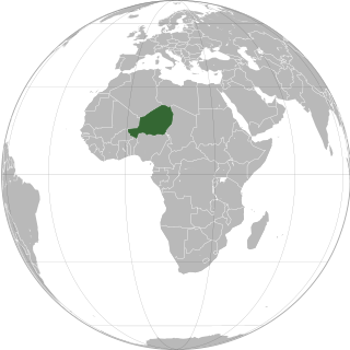
Niger or the Niger, officially the Republic of the Niger, is a landlocked country in West Africa. It is a unitary state bordered by Libya to the northeast, Chad to the east, Nigeria to the south, Benin and Burkina Faso to the southwest, Mali to the west, and Algeria to the northwest. It covers a land area of almost 1,270,000 km2 (490,000 sq mi), making it the largest landlocked country in West Africa. Over 80% of its land area lies in the Sahara. Its predominantly Muslim population of about 25 million lives mostly in clusters in the south and west of the country. The capital Niamey is located in Niger's southwest corner.

The Departments of Niger are subdivided into communes. As of 2005, in the seven Regions and one Capital Area, there were 36 départements, divided into 265 communes, 122 cantons and 81 groupements. The latter two categories cover all areas not covered by Urban Communes or Rural Communes, and are governed by the Department, whereas Communes have elected councils and mayors. Additional semi-autonomous sub-divisions include Sultanates, Provinces and Tribes (tribus). The Nigerien government estimates there are an additional 17000 Villages administered by Rural Communes, while there are over 100 Quartiers administered by Urban Communes.
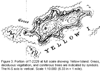
Yellow Island, one of the San Juan Islands, is an 11-acre (4.5 ha) island, located south-west of Orcas Island, and north of Shaw Island, near Jones Island State Park, in San Juan County, Washington, United States. The island is home to a wide array of flora and fauna, including over 50 species of wildflowers, bald eagles, harbor seals, black oystercatchers, and harlequin ducks. The island was purchased in 1979 by The Nature Conservancy, and is administered as a nature preserve.
Guidimouni is a town in southern Niger. It is near the city of Zinder. As of 2012, it had a population of 69,587.
Gueskerou is a village and commune in southeastern Niger. As of 2012, the commune's population was 37,836 people.
Dargol is a village and rural commune in Niger. As of 2012, it had a population of 147,779.
Doguerawa is a village and rural commune in Niger. As of 2012, it had a population of 117,975. 8,673 people live in Doguerawa village.
Fakara is a village and rural commune in Niger. As of 2012, it had a population of 19,077.
Gouchi is a village and rural commune in the Dungass Department of the Zinder Region of Niger. As of 2012, it had a population of 71,612.

Inates is a village and rural commune in the Tillabéri Region of Niger. As of 2012, it had a population of 23,503.
Kieche is a village and rural commune in Niger. As of 2012, it had a population of 48,980.

Kiota is a small town and rural commune in Niger in the Boboye Department, Dosso Region. As of 2012, it had a population of 25,282.
It is the seat of the most important Tijaniyyah community in Niger.
The weekly market is on Fridays.
Malawa, Niger is a village and rural commune in the Dungass Department of the Zinder Region of Niger. As of 2012, it had a population of 88,954.
Namaro is a village and rural commune in Niger. As of 2012, it had a population of 55,094.
Sabon-Machi is a village and rural commune in Niger. As of 2012, it had a population of 35,988.
Tagazar is a village and rural commune in Niger. As of 2012, it had a population of 107,134.
Tirmini is a village and rural commune in Niger.
Toumour is a village and rural commune in Niger located near the Niger–Nigeria border. As of 2011, the commune had a total population of 1336 people.
The Maouri people are an ethnic group in western Africa. They are one of the major ethnic groups of Niger, and are concentrated around the Dallol Maouri of the Niger River, extending from Matankari, near Niamey, to Gaya. They are a subgroup of the Hausa people, and speak both the Hausa language and the Djerma language. When using the Zarma language, they are known as the Arawa people.