Makalondi | |
|---|---|
Commune | |
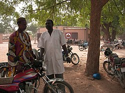 Health Center in Makalondi | |
| Area | |
| • Total | 1,226 km2 (473 sq mi) |
| Population | |
| • Total | 73,271 |
Makalondi is a rural commune in the Torodi department of Niger. As of 2012, it had a population of 73,271. [1]
Makalondi | |
|---|---|
Commune | |
| Health Center in Makalondi | |
| Area | |
| • Total | 1,226 km2 (473 sq mi) |
| Population | |
| • Total | 73,271 |
Makalondi is a rural commune in the Torodi department of Niger. As of 2012, it had a population of 73,271. [1]
Makalondi is located in the Sahel. It borders Burkina Faso in the south and west.
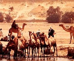
On the higher plains of Makalondi, for which tiger bush is typical as a vegetation form, grow winged seed plants, acacias, monkey bread trees, doum palms and caritat trees. Khaya senegalensis and Tamarind thrive in the lowlands. [2] The average rainfall level between 1961 and 1990 was about 600 mm (23 in). [3] The Makalondi District is recognized as an Important Bird Area. The major birds include the Long-tailed glossy starling and the Savile's bustard. The birds were studied mainly by Pierre Souvairan, who lived in the area for 30 years between 1968 and 1998. [3] Until the 1970s, large mammals, including Loxodonta africana, Panthera leo and Syncerus caffer were common, particularly in the western part of the area. Most disappeared following extensive clearance of land for agriculture during the 1980s. [3]
Makalondi was separated from the territory of the rural community of Torodi on 18 August 2009 as a separate commune. [4] The reasons for the separation of Torodi included the high population density in this area and in particular the position of Makalondi as an important border town. [5] Since 2011, Makalondi has not belonged to the Say department, but to the newly founded department of Torodi.
Makalondi had 73,271 inhabitants as of the 2012 census, which lived in 8975 households. [6]
In Makalondi there are two Roman Catholic parishes belonging to the Archdiocese of Niamey: the parish of St. Francis in the main town, founded in 1967, and the parish of St. Spirit in the village of Bomanga (Bomoanga), founded in 1994. Its members are mainly members of the Gurma people ethnic group. [7]
Niger or the Niger, officially the Republic of the Niger, is a landlocked country in West Africa named after the Niger River. Niger is bordered by Libya to the northeast, Chad to the east, Nigeria to the south, Benin to the southwest, Mali to the northwest, Burkina Faso to the southwest, and Algeria to the northwest. Niger covers a land area of almost 1,270,000 km2 (490,000 sq mi), making it the largest country in West Africa. Over 80% of its land area lies in the Sahara Desert. The country's predominantly Muslim population of about 22 million live mostly in clusters in the far south and west of the country. The capital and largest city is Niamey, located in Niger's southwest corner.

Niger is a landlocked nation in West Africa located along the border between the Sahara and Sub-Saharan regions. Its geographic coordinates are longitude 16°N and latitude 8°E. Its area is 1.267 million square kilometers, of which 1 266 700 km² is land and 300 km² water, making Niger slightly less than twice the size of France.
The Niger Armed Forces (FAN) includes military armed force service branches, paramilitary services branches and the National Police. The Niger Army, Niger Air Force and the National Gendarmerie of Niger are under the Ministry of Defense whereas the National Guard of Niger and the National Police fall under the command of the Ministry of Interior. With the exception of the National Police, all military and paramilitary forces are trained in military fashion. The President of Niger is the supreme commander of the entire armed forces.

Niamey is the capital and largest city of the West African country of Niger. Niamey lies on the Niger River, primarily situated on the east bank. Niamey's population was counted as 978,029 as of the 2012 census; the Niamey Capital District, covering 670 km2, had 1,026,848 people. As of 2017, population projections show the capital district growing at a slower rate than the country as a whole, which has the world's highest fertility rate.
The Sahel is the ecoclimatic and biogeographic realm of transition in Africa between the Sahara to the north and the Sudanian savanna to the south. Having a semi-arid climate, it stretches across the south-central latitudes of Northern Africa between the Atlantic Ocean and the Red Sea. The name is derived from the Arabic term for "coast, shore": this is explained as being used in a figurative sense. However, such figurative use is unattested in Classical Arabic, and it has been suggested that the word may originally have been derived from the Arabic word sahl سهل "plain" instead.

The regions of Niger are subdivided into 63 departments. Before the devolution program on 1999-2005, these departments were styled arrondissements. Confusingly, the next level up (regions) had, before 2002-2005 been styled departments. Prior to a revision in 2011, there had been 36 departments. A draft law in August 2011 would expand that number to 63. Until 2010, arrondissements remained a proposed subdivision of departments, though none were used. The decentralisation process, begun in the 1995-1999 period replaced appointed Prefects at Departmental/Arrondisement level with elected councils, first elected in 1999. These were the first local elections held in the history of Niger. Officials elected at commune level are then selected as representatives at Departmental, regional, and National level councils and administration. The Ministry of Decentralisation was created to oversee this task, and to create a national consultative council of local officials.
Diffa is one of the seven Regions of Niger, located in the southeast of the country. The capital of the region is Diffa.

Tillabéri is one of the eight Regions of Niger; the capital of the Region is Tillabéri. Tillabéri Region was created in 1992, when Niamey Region was split, with Niamey and its immediate hinterland becoming a new capital district enclaved within Tillabéri Region.

The Great Green Wall or Great Green Wall of the Sahara and the Sahel is Africa's flagship initiative to combat the increasing desertification. Led by the African Union, the initiative aims to transform the lives of millions of people by creating a mosaic of green and productive landscapes across North Africa.

Say is a department of the Tillabéri Region in Niger. Its capital city is Say, and includes the towns of Guéladjo, Tamou, and Torodi. It abuts the urban Region of Niamey, and lies across the Niger River to the southwest of the capital. It extends to the Burkina Faso border over 60 km to the west, and the northernmost border with Benin in the south. The Say area is today divided between the riverine valley in the east of the Department, and the more sparsely populated areas to the west, which are intercut with a series of eastward flowing tributaries. The Niger river, a broad shallow channel at Niamey and at Say, passes through a series of gorges and cataracts, called the "W" bend for the shape the river takes, in the south of the Say Department. To the west of these rapids lies what is now the W Regional Park, a sparsely populated area historically plagued by insect borne diseases of both humans and cattle. Now a park and tourist attraction, its history as a "no mans land" has made it a refuge for remaining wild animals, as well as several undisturbed archeological sites. From at least the 16th century CE, the Zarma people moved south into this area from the northern plateau around what is now Oullam. The inhabitants at the time were related to the Gourma people, who form most of the population of the northwestern part of the Department today. In the 18th and 19th century, the town of Say was founded by Fulani migrants from the Gao region of modern Mali, with others expanding from what is now northeast Burkina Faso. Between 1810 and the arrival of European writer Heinrich Barth in 1854, Fulani Muslims led by Alfa Mohamed Diobo of Djenné had established the Emirate of Say. The reputation for piety and learning of Mohamed Diobo and his followers helped turn Say from a small river village into a town of 30,000, famed across West Africa as a center of learning.

Agriculture is the primary economic activity of a majority of Niger's 17 million citizens.

Keita is a town and commune in Niger. It is the capital of the Keita Department, within the Tahoua Region, and has a population of 10,631 as of 2012.
Abala, Niger is a village and rural commune in Niger.
Garhanga is a village and rural commune in Niger. It is located in the Keita Department of the Tahoua region. As of 2012, it has a population of 69,712.
Kokorou or Kokoro is a town and rural commune in the Téra Department of western Niger.
Tamaske is a city and rural commune in Niger. It is located in the Keita Department, in the Tahoua Region.
Tarka, Niger is a village and rural commune in Niger. It is located in the Belbédji Departement of the Zinder Region. As of 2010 the commune had a population of 86,695.

Tassara is a village and rural commune in Niger.
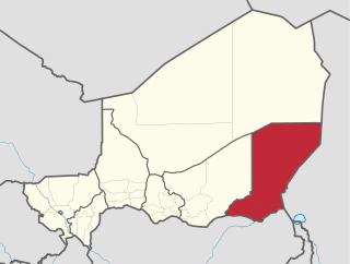
Torodi is a small town and a rural commune in Niger. As a rural center, Torodi hosts a large weekly market and the seat of local tribal authority (canton). Torodi is in the Say Department of the Tillaberi Region, which surrounds the national capital, Niamey. Say Department, with its capital at the large Niger River town of Say, abuts Niamey to the southwest and across the river to the west. The town of Torodi lies about 60 km due west of the city of Say and 50 km east of the border with Burkina Faso. Torodi itself lies on a tributary of the Niger, the Gourbi river.
The Kouré shooting was a mass shooting that occurred in Niger on 9 August 2020. The attack left at least 8 civilians dead, six French and two Nigeriens. The attack took place in Kouré, a rural community in Tillabéri Region.