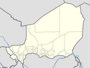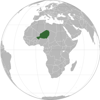
Niger or the Niger, officially the Republic of the Niger, is a landlocked country in West Africa. It is a unitary state bordered by Libya to the northeast, Chad to the east, Nigeria to the south, Benin and Burkina Faso to the southwest, Mali to the west, and Algeria to the northwest. It covers a land area of almost 1,270,000 km2 (490,000 sq mi), making it the largest landlocked country in West Africa and the second largest landlocked nation in Africa behind Chad. Over 80% of its land area lies in the Sahara. Its predominantly Muslim population of about 25 million lives mostly in clusters in the south and west of the country. The capital Niamey is located in Niger's southwest corner.

The music of Niger has developed from the musical traditions of a mix of ethnic groups; Hausa, the Zarma-Songhai, Tuareg, Fula, Kanuri, Toubou, Diffa Arabs and Gurma and the Boudouma from Lac Chad.
Tahoua is a city in Niger and the administrative centre of the Department of Tahoua and the larger Tahoua Region. It is the fourth largest town in the country, with a population of 117,826.

The regions of Niger are subdivided into 63 departments. Before the devolution program on 1999–2005, these departments were styled arrondissements. Confusingly, the next level up (regions) had, before 2002-2005 been styled departments. Prior to a revision in 2011, there had been 36 departments. Until 2010, arrondissements remained a proposed subdivision of departments, though none were used. The decentralisation process, begun in the 1995-1999 period replaced appointed Prefects at Departmental or Arrondissement level with elected councils, first elected in 1999. These were the first local elections held in the history of Niger. Officials elected at commune level are then selected as representatives at Departmental, regional, and National level councils and administration. The Ministry of Decentralisation was created to oversee this task, and to create a national consultative council of local officials.

Agadez Region is one of the seven regions of Niger. At 667,799 square kilometres (257,839 sq mi), it covers more than half of Niger's land area, and is the largest region in the country, as well as the largest African state subdivision. The capital of the department is Agadez.

Tahoua is one of eight Regions of Niger. The capital of the region is the commune of Tahoua. The region covers 106,677 km².

The Region of Maradi is one of seven regions of Niger. It is located in south-central Niger, east of the Region of Tahoua, west of Zinder, and north of the Nigerian city of Katsina. The administrative centre is at Maradi. The population of the Region is predominantly Hausa.

Abalak is a town located in the Tahoua Region, Abalak Department of northern Niger. It is both a town and Commune: a local administrative division. It is the seat (Chef-lieu) of Abalak Department, one of eight subdivisions of Tahoua Region. The town had a population of less than 74,719 at the 2012 census.

Madaoua is a town and urban commune located in the Tahoua Region of Niger. It has a population of 127,254. It is seat of the Madaoua Department, forming the southwest corner of the Region, and is an Urban Commune.

Dongondoutchi is a commune in Niger. It is located about 300 km east of the capital Niamey and 40 km from the Nigerian border. It lies on national route 1 which links the capital to the towns of Maradi and Zinder to the east and the RN25 heading to north to Tahoua, Agadez and Arlit.
Goundam is a commune and town in north central Mali, in the Tombouctou Region. It is the capital of Goundam Cercle, one of five subdivisions of the Region. In the 2009 census the commune had a population of 16,253. The main ethnic groups are Songhay, Tuareg and Fulani.
Ouallam is a town around 90 km north of Niamey in southwestern Niger. It is the capital of Ouallam Department, one of four departments in the Tillabéri Region.
The following outline is provided as an overview of and topical guide to Niger:

Bouza is a department of the Tahoua Region in Niger. Its capital lies at the city of Bouza, and also includes the town of Déoulé. As of 2012, the department had a total population of 445,363 people.

Téra is a department of the Tillabéri Region in Niger. Its capital is the city of Téra. As of 2011, the department had a total population of 579,658 people.
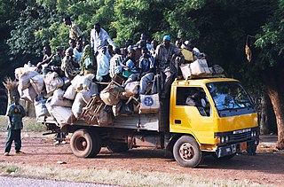
Seasonal migration, locally called the Exode, plays an important part of the economic and cultural life of the West African nation of Niger. While it is a common practice in many nations, Niger sees as much as a third of its rural population travel for seasonal labour, during the Sahelian nation's long dry season. Common patterns of seasonal travel have been built up over hundreds of years, and destinations and work vary by community and ethnic group.
Illela, Niger is a town and urban commune in Niger.
Azarori is a village and rural commune in Niger.
Bankilaré is a village and rural commune in Niger. Bankilaré commune, centered on the town of the same name, is in Téra Department, Tillabéri Region, in the northwestern corner of the country. The town lies 60 km north of Departmental capital Téra, and around the same distance from the Burkina Faso border and the Mali border. As of 2012, it had a population of 84,893.
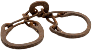
Slavery in Niger involves different practices which have been practiced in the Sahel region for many centuries and which persist to this day. The Bornu Empire in the eastern part of Niger was an active part of the trans-Saharan slave trade for hundreds of years. Other ethnic groups in the country similarly had a history of slavery, although this varied and in some places slavery was largely limited to the political and economic elite.