
Niamey is the capital and largest city of Niger. Niamey lies on the Niger River, primarily situated on the east bank. Niamey's population was counted as 1,026,848 as of the 2012 census. As of 2017, population projections show the capital district growing at a slower rate than the country as a whole, which has the world's highest fertility rate. The city is located in a pearl millet growing region, while manufacturing industries include bricks, ceramic goods, cement, and weaving.
Tahoua is a city in Niger and the administrative centre of the Department of Tahoua and the larger Tahoua Region. It is the fourth largest town in the country, with a population of 117,826.

The regions of Niger are subdivided into 63 departments. Before the devolution program on 1999–2005, these departments were styled arrondissements. Confusingly, the next level up (regions) had, before 2002-2005 been styled departments. Prior to a revision in 2011, there had been 36 departments. A draft law in August 2011 would expand that number to 63. Until 2010, arrondissements remained a proposed subdivision of departments, though none were used. The decentralisation process, begun in the 1995-1999 period replaced appointed Prefects at Departmental or Arrondissement level with elected councils, first elected in 1999. These were the first local elections held in the history of Niger. Officials elected at commune level are then selected as representatives at Departmental, regional, and National level councils and administration. The Ministry of Decentralisation was created to oversee this task, and to create a national consultative council of local officials.

N'guigmi is a city and Commune of fifteen thousand in the easternmost part of Niger, very near to Lake Chad – lying on its shore until the lake retreated. It is a crossroads for the traditional camel caravans of the Toureg and for traders plying North and South across the Sahara.
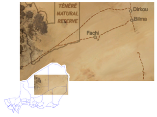
Bilma is an oasis town and commune in north east Niger with, as of the 2012 census, a total population of 4,016 people. It lies protected from the desert dunes under the Kaouar Cliffs and is the largest town along the Kaouar escarpment. It is known for its gardens, for salt and natron production through evaporation ponds, date cultivation, and as the destination of one of the last Saharan caravan routes.
Timia is a small town and commune in northern Niger, situated at an oasis in the Aïr Mountains, Agadez Region, Arlit Department. Visitors come to the Tuareg town to see a seasonal waterfall, a former French fort and the nearby ruined town of Assodé. As of 2012, the commune had a total population of 19,076 people.

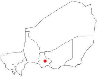
Maradi is the second largest city in Niger and the administrative centre of Maradi Region. It is also the seat of the Maradi Department and an Urban Commune.
Dosso is one of the eight Regions of Niger. The region has an area of 31,002 square kilometres (11,970 sq mi), with a population of 2,754,500 as of 2020.

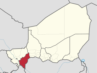
The Region of Maradi is one of seven regions of Niger. It is located in south-central Niger, east of the Region of Tahoua, west of Zinder, and north of the Nigerian city of Katsina. The administrative centre is at Maradi. The population of the Region is predominantly Hausa.

Madaoua is a town and urban commune located in the Tahoua Region of Niger. It has a population of 127,254. It is seat of the Madaoua Department, forming the southwest corner of the Region, and is an Urban Commune.

Tessaoua, formerly known as Tessawa, is a city located in the Maradi Region of Niger. It has a population of 43,409. Tessaoua is historically an important city in its region. It is situated in a central geographical location. Tessaoua is a midpoint on a historical trade route between Agadez, Niger, in the north and Kano, Nigeria, in the south. During the collapse of the sultanates of Bornu and Sokoto during the late 19th century, the local ruler declared his territory the sultanate of Tessaoua; he signed a treaty of protection with the French captain Cazemajou in 1897, prior to the explorer's murder in nearby Zinder.
Mayahi is a town located in the Maradi Region of Niger. It is the seat of Mayahi Department and a Commune about 45 km from Tessaoua. In 2012 it had a population of 14,000 in the urban area. The name "Mayaki" is also a rulers' title among the Sudié and Maouri: local subgroups of the Hausa people.
The Departments of Niger are subdivided into communes. As of 2005, in the seven Regions and one Capital Area, there were 36 départements, divided into 265 communes, 122 cantons and 81 groupements. The latter two categories cover all areas not covered by Urban Communes or Rural Communes, and are governed by the Department, whereas Communes have elected councils and mayors. Additional semi-autonomous sub-divisions include Sultanates, Provinces and Tribes (tribus). The Nigerien government estimates there are an additional 17000 Villages administered by Rural Communes, while there are over 100 Quartiers administered by Urban Communes.
Bani-Bangou is a town in southwestern Niger, in rural northern Ouallam Department, Tillabéri Region. It is the capital of the rural commune of Bani-Bangou. On the main highway from Ouallam on the route to the Malian border town of Andéramboukane. It is 135 km northeast of Ouallam and 70 km by road from Mali. It around 200 km cross country from Niamey. The town is the seat of a "Rural Commune" of the same name, one of four rural communes in the department. Nearby villages include Gorou, Bassikwana, and Tondi Tiyaro Kwara to the north; Koloukta and Dinara along the highway west; Ouyé to the southeast.
Goure is a Commune and town in southeastern Niger, Zinder Region, Goure Department, of which it is the seat. As of 2012, it had a population of 73,732.
Dirkou is a town in the Bilma Department, Agadez Region of north-eastern Niger. It lies in the northern Kaouar escarpment, a north–south line of cliffs which form an isolated oasis in the Sahara desert. As of 2011, the commune had a total population of 14,998 people. Apart from the main city of Dirkou, the rural communities of Achénouma, Aney, and Emi Tchouma lie within the borders of the commune.

The Route Nationale No. 1 is an important highway in Niger. It connects the east part of the country to the west. RN1 runs approximately 1,200 km (750 mi) from Koutogou in the west to N'Guigmi in the east, via Dosso, Maradi, Zinder, and Diffa. The first large paved section, between Gouré and N'Guigmi, was surfaced in 1971–72. This section, in the distant and sparsely populated east, is now the most degraded section and in part completely eroded. It was named the "Route de l'Unité" in the 1970s. By 1980, it was joined by the second long all-weather road in Niger, the "Uranium Highway," running from Niamey to Arlit in the far north.

The Société Nigérienne de Transports de Voyageurs or SNTV is the Nigerien government owned bus and public transport company.

Harikanassou is a large village and rural commune in the Boboye Department of the Dosso Region of southwest Niger, 90.7 kilometres (56.4 mi) by road southeast of the capital of Niamey. At the time of the 2012 census, the rural community had 23,567 residents living in 3,340 households. Onion cultivation is a chief source of income for many, along with the cultivation of lettuce, beans, squashes, and tomatoes.
Tamou is a village and "Rural commune" in Niger. The town is capital of its Rural Commune in the Say Department of Tillabéri Region, in the far southwest of the nation. It is southwest of Niamey, on the right (western) bank of the Niger River, between the departmental capital Say and the border of Burkina Faso. Tamou Commune is home to the Tamou Total Reserve, a wildlife reserve which is part of the larger W National Park and Transborder Reserve. The Tamou Reserve, in which local people also live, is primarily dedicated to the protection of African Elephant populations which migrate through the region.

