Maradi Region

Last updated
Maradi
Village maradi niger.jpg
A village in Maradi
Maradi in Niger.svg
Location within Niger
Coordinates: 13°30′N7°6′E / 13.500°N 7.100°E / 13.500; 7.100
CountryFlag of Niger.svg Niger
Capital Maradi
Government
  GovernorSchiabou Aboubacar
Area
  Total
35,100 km2 (13,600 sq mi)
Population
 (2020 estimate)
  Total
4,728,200
  Density135/km2 (349/sq mi)
Time zone UTC+1 (West Africa Time)
HDI (2021)0.380 [1]
low · 4th of 7

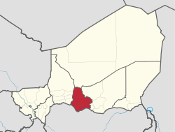
The Region of Maradi is one of seven regions of Niger. It is located in south-central Niger, east of the Region of Tahoua, west of Zinder, and north of the Nigerian city of Katsina. The administrative centre is at Maradi, with the population of the Region being predominantly Hausa.

Contents

History

In 2021, a large gold mine collapse d in the region, killing 18 miners. [2]

Geography

Maradi borders Agadez Region to the north, Zinder Region to the east, Nigeria to the south (specifically the states of Katsina, Zamfara, and Sokoto), and Tahoua Region to the west. Most of the 35,100 km² [3] of land is classified as "Sahel", though the northern parts merge into the Sahara desert, and the very southern edges along the border with Nigeria get almost 600 mm a year in average rainfall, with some areas receiving as much as 650–700 mm in better years. [3] Lake Madarounfa lies south of Maradi, into which the seasonal Goulbi N'Gabi and Goulbi N'Maradi rivers flow. [4]

Settlements

Maradi is the regional capital; other major settlements include Adjekoria, Aguie, Attantane, Azagor, Bader Goula, Baoudetta, Bermo, Birni Lalle, Chadakori, Dakoro, Dan-Goulbi, Djiratawa, El Allassane Maireyrey, Gababedji, Gabi, Gangara, Gazaoua, Guidan Amoumoune, Guidan Roumji, Guidan Sori, Hawandawaki, Issawane, Kanan-Bakache, Kollo, Koona, Korahane, Korgom, Kornaka, Madarounfa, Maiyara, Mar-Jirgui, Mayahi, Ourafane, Roumboui, Sabon-Machi, Safo, Sarkin Haoussa, Sarkin Yamma, Tagriss, Tchadoua, Tchake, Tessaoua and Tibiri. [5]

Administrative subdivisions

Departments of Maradi (old borders) Maradi Arrondissements.png
Departments of Maradi (old borders)

Maradi is divided into 8 Departments and one commune:

Economy

The Niger-Nigeria border dips south below the Region's capital, forming an area sometimes called the "breadbasket" of Niger.[ citation needed ] While tobacco, mangoes, wheat, soy beans, and even cotton are cultivated in some areas, the predominant crops are groundnuts, grown commercially, millet, sorghum, and cow peas, typically for domestic consumption. [4]

Demographics

Hausa women in a village Hausa women near Maradi (2).jpg
Hausa women in a village

Maradi is the most densely populated region of Niger, [3] with a population of 3,117,810 as of 2011. [6] Culturally, the Maradi Region forms the west-central section of the Nigerien Hausaland, which extends along the Nigerian border west to Dogondoutchi and east to just beyond Zinder. Other groups include the Fula people (including the Wodaabe, who predominate in the north and east of the region), and the Tuareg peoples, especially in the region's north and along major trade routes. [7] The Tagdal language, thought to be a mixed Songhay-Tuareg language, is also spoken. [7]

Historical population
YearPop.±%
1977949,747    
19851,389,433+46.3%
20012,235,570+60.9%
20123,402,094+52.2%
source: [8]

See also

References

  1. "Sub-national HDI - Area Database - Global Data Lab". hdi.globaldatalab.org. Retrieved 2018-09-13.
  2. "At least 18 killed in artisanal gold mine collapse in Niger". Reuters. 2021-11-08. Retrieved 2021-12-22.
  3. 1 2 3 Samuel Decalo, Historical Dictionary of Niger (3rd ed.). Scarecrow Press, Boston & Folkestone, (1997) ISBN   0-8108-3136-8 pp.209–210
  4. 1 2 Geels, Jolijn, (2006) Bradt Travel Guide - Niger, pgs. 203-212
  5. "Carte de référence: Niger - Région de Maradi (1 février 2019)" (PDF). REACH Initiative. Retrieved 29 October 2019.
  6. Annuaire statistique du Niger
  7. 1 2 "Languages of Niger". Ethnologue . Retrieved 24 October 2019.
  8. Niger: Administrative Division population statistics