
Alibori is the largest and northernmost department of Benin. Externally the department borders the countries of Burkina Faso, Niger, and Nigeria, and internally the departments of Atakora and Borgou. The department of Alibori was created in 1999 when it was split off from Borgou Department and is named after the Alibori River.
Dosso is one of the eight Regions of Niger. The region has an area of 31,002 square kilometres (11,970 sq mi), with a population of 2,754,500 as of 2020.

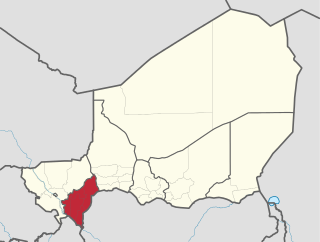
Tahoua is one of eight Regions of Niger. The capital of the region is the commune of Tahoua. The region covers 106,677 km².
Tillabéri is one of the seven Regions of Niger; the capital of the Region is Tillabéri. Tillabéri Region was created in 1992, when Niamey Region was split, with Niamey and its immediate hinterland becoming a new capital district enclaved within Tillabéri Region.

The Region of Maradi is one of seven regions of Niger. It is located in south-central Niger, east of the Region of Tahoua, west of Zinder, and north of the Nigerian city of Katsina. The administrative centre is at Maradi. The population of the Region is predominantly Hausa.

Abalak is a town located in the Tahoua Region, Abalak Department of northern Niger. It is both a town and Commune: a local administrative division. It is the seat (Chef-lieu) of Abalak Department, one of eight subdivisions of Tahoua Region. The town had a population of less than 74,719 at the 2012 census.

Dakoro is a town and commune located in the Maradi Region of Niger. As of 2012, it had a population of 71,201. It is the capital of the Dakoro Department.

Madaoua is a town and urban commune located in the Tahoua Region of Niger. It has a population of 127,254. It is seat of the Madaoua Department, forming the southwest corner of the Region, and is an Urban Commune.
Bouza is a town in southwestern Niger. A town of eight thousand, it is the administrative center of Bouza Department, part of Tahoua Region.

Tahoua is a department of the Tahoua Region in Niger. Its capital lies at the city of Tahoua, that is not part of the Department. It includes the towns of Bambeye and Kalfou. As of 2012, the department had a total population of 432,659 people.
Bouza is a department of the Tahoua Region in Niger. Its capital lies at the city of Bouza, and also includes the town of Déoulé. As of 2012, the department had a total population of 445,363 people.
Illela is a department of the Tahoua Region in Niger. Its capital lies at the city of Illela.As of 2012, the department had a total population of 335,785 people.
Madaoua is a department of the Tahoua Region in Niger. Its capital lies at the city of Madaoua. As of 2012, the department had a total population of 545,538 people.
Tchintabaraden is a department of the Tahoua Region in Niger. Its capital lies at the city of Tchintabaraden. As of 2012, the department had a total population of 145,086 people.
Akoubounou, or Akabinu in the local Tin Sert language, is a village located in the west to the town of Abalak, in the Tahoua Region of Niger.
Keita is a town and commune in Niger. It is the capital of the Keita Department, within the Tahoua Region, and has an urban population of 10,631 as of 2012.
The Ader Doutchi Maggia Rural Development Project (PDR-ADM), better known as Keita Project, is a development project in Keita Department in central Niger. The Project has taken place in four phases, the first starting in 1983 and the most recent beginning in 2003. It was run initially by the Italian government's Italian Development and Cooperation Bureau, as part of its 'Italian Initiative for the Sahel', with significant help from the United Nations. The fourth phase is being run by the UNDP. As of September 2009, the Project has cost approximately US$88 million, with the majority of funding coming from the Italian government.
Garhanga is a village and rural commune in Niger. It is located in the Keita Department of the Tahoua region. As of 2012, it has a population of 69,712.
Tamaske is a city and rural commune in Niger. It is located in the Keita Department, in the Tahoua Region.

Tassara is a village and rural commune in Niger.
