Diffa is a city and Urban Commune in the extreme southeast of Niger, near the border with Nigeria. It is the administrative seat of both Diffa Region, and the smaller Diffa Department. As of 2012, the commune had a total population of 56,437 people.
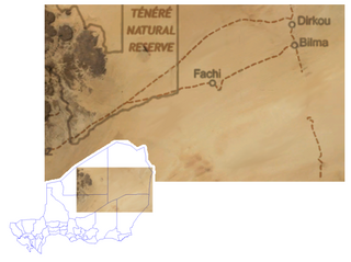
Bilma is an oasis town and commune in north east Niger with, as of the 2012 census, a total population of 4,016 people. It lies protected from the desert dunes under the Kaouar Cliffs and is the largest town along the Kaouar escarpment. It is known for its gardens, for salt and natron production through evaporation ponds, date cultivation, and as the destination of one of the last Saharan caravan routes.
Dosso is one of the eight Regions of Niger. The region has an area of 31,002 square kilometres (11,970 sq mi), with a population of 2,754,500 as of 2020.

Gaya is a city in the Gaya Department of the Dosso Region of Niger. The city is situated 254 km southeast of the capital, Niamey, is located on the banks of the Niger River, and is near the borders with Benin and Nigeria. Gaya has a population of 28,385. The wettest area in Niger, Gaya averages 800 mm in rainfall a year.

Diffa is a department of the Diffa Region in Niger. It is bordered by Chad to the east. Its capital lies at the city of Diffa. As of 2012, the department had a total population of 209,249 people.

Dosso is a department of the Dosso Region in Niger. Its capital lies at the city of Dosso. As of 2012, the department had a total population of 492,560 people.

Tahoua is a department of the Tahoua Region in Niger. Its capital lies at the city of Tahoua, that is not part of the Department. It includes the towns of Bambeye and Kalfou. As of 2012, the department had a total population of 432,659 people.
Arlit is a department of the Agadez Region in Niger. Its capital lies at the city of Arlit. As of 2012, the department had a total population of 105,025 people.
Mainé-Soroa is a department of the Diffa Region in Niger. Its capital lies at the city of Mainé-Soroa.
Boboye is a department of the Dosso Region in Niger. Its capital lies at the city of Birni N'Gaouré. As of 2012, the department had a total population of 252,597 people.
Loga is a department of the Dosso Region in Niger. Its capital lies at the city of Loga. As of 2012, the department had a total population of 175,543 people.

Mayahi Department is a department of the Maradi Region in Niger. Its capital lies at the city of Mayahi. In the mid-1990s, the Department had a population of 125,000, with 2,200 in Mayahi town. As of 2012, the department had a total population of 557,186 people.
Illela is a department of the Tahoua Region in Niger. Its capital lies at the city of Illela.As of 2012, the department had a total population of 335,785 people.
Tchintabaraden is a department of the Tahoua Region in Niger. Its capital lies at the city of Tchintabaraden. As of 2012, the department had a total population of 145,086 people.

Ouallam is a department of the Tillabéri Region in Niger. Its capital lies at the city of Oullam, which is designated an Urban Commune. The department also includes the Rural Communes of Simiri and Tondikiwindi, as well as the towns of Bani Bangou and Dingazi. As of 2012, the department had a total population of 327,224 people.

Goure is a department of the Zinder Region in Niger. Its capital lies at the city of Goure. As of 2012, the department had a total population of 327,818 people.
Magaria is a department of the Zinder Region in Niger. Its capital lies at the city of Magaria. As of 2012, the department had a total population of 577,743 people.
Tanout is a department of the Zinder Region in Niger. Its administrative seat is the city of Tanout. As of 2012, the department had a total population of 429,150 people.
Toumour is a village and rural commune in Niger located near the Niger–Nigeria border. As of 2012, the commune had a total population of 11,713 people.
Yaouri is a village and rural commune in Matameye Department in Niger.
