Diffa is a city and Urban Commune in the extreme southeast of Niger, near the border with Nigeria. It is the administrative seat of both Diffa Region, and the smaller Diffa Department. As of 2012, the commune had a total population of 56,437 people.

The regions of Niger are subdivided into 63 departments. Before the devolution program on 1999–2005, these departments were styled arrondissements. Confusingly, the next level up (regions) had, before 2002-2005 been styled departments. Prior to a revision in 2011, there had been 36 departments. A draft law in August 2011 would expand that number to 63. Until 2010, arrondissements remained a proposed subdivision of departments, though none were used. The decentralisation process, begun in the 1995-1999 period replaced appointed Prefects at Departmental or Arrondissement level with elected councils, first elected in 1999. These were the first local elections held in the history of Niger. Officials elected at commune level are then selected as representatives at Departmental, regional, and National level councils and administration. The Ministry of Decentralisation was created to oversee this task, and to create a national consultative council of local officials.

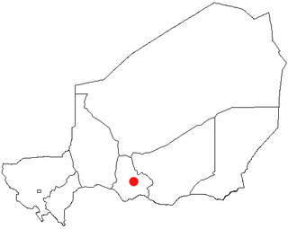
The Region of Maradi is one of seven regions of Niger. It is located in south-central Niger, east of the Region of Tahoua, west of Zinder, and north of the Nigerian city of Katsina. The administrative centre is at Maradi. The population of the Region is predominantly Hausa.
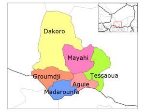
Mayahi is a town located in the Maradi Region of Niger. It is the seat of Mayahi Department and a Commune about 45 km from Tessaoua. In 2012 it had a population of 14,000 in the urban area. The name "Mayaki" is also a rulers' title among the Sudié and Maouri: local subgroups of the Hausa people.

The Goulbi de Maradi is a river in south central Niger and north central Nigeria. Between its source near Katsina in Nigeria, and its end in the Rima River, the Goulbi de Maradi never flows more than 48 kilometres (30 mi) from the Niger–Nigeria border. Though important for agriculture and pastoralism, and flowing through the Niger cities of Maradi, Guidan Roumdji, and Madarounfa, the Goulbi de Maradi is a seasonal river and flows only during the rainy season.

Diffa is a department of the Diffa Region in Niger. It is bordered by Chad to the east. Its capital lies at the city of Diffa. As of 2012, the department had a total population of 209,249 people.

Dosso is a department of the Dosso Region in Niger. Its capital lies at the city of Dosso. As of 2012, the department had a total population of 492,560 people.
Boboye is a department of the Dosso Region in Niger. Its capital lies at the city of Birni N'Gaouré. As of 2012, the department had a total population of 252,597 people.
Dogondoutchi is a department of the Dosso Region in Niger. Its capital lies at the city of Dogondoutchi. As of 2012, the department had a total population of 372,473 people.
Loga is a department of the Dosso Region in Niger. Its capital lies at the city of Loga. As of 2012, the department had a total population of 175,543 people.

Madarounfa is a department of the Maradi Region in Niger. Its capital is Madarounfa. As of 2012, the department had a total population of 448,863 people.
Tessaoua is a department of the Maradi Region in Niger. Its capital lies at the city of Tessaoua. As of 2011, the department had a total population of 479,384 people.

Guidanroumdji is a town and urban commune in Niger. As of 2012, it had a population of 95,791.

Tibiri is a town and urban commune in Niger. As of 2012, it had a population of 125,806. It is the seat of the Sultan of Gobir.
Guidan Amoumoune is a village and rural commune in Niger. As of 2012, it had a population of 88,199.
Guidan Sori is a village and rural commune in Niger. As of 2012, it had a population of 93,771.
Toumour is a village and rural commune in Niger located near the Niger–Nigeria border. As of 2012, the commune had a total population of 11,713 people.
Yaouri is a village and rural commune in Matameye Department in Niger.
Djougou III is an arrondissement in the Donga department of Benin. It is an administrative division under the jurisdiction of the commune of Djougou. According to the population census conducted by the Institut National de la Statistique Benin on February 15, 2002, the arrondissement had a total population of 17,713.