Diffa is a city and Urban Commune in the extreme southeast of Niger, near the border with Nigeria. It is the administrative seat of both Diffa Region, and the smaller Diffa Department. As of 2012, the commune had a total population of 56,437 people.

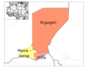
N'guigmi is a city and Commune of fifteen thousand in the easternmost part of Niger, very near to Lake Chad – lying on its shore until the lake retreated. It is a crossroads for the traditional camel caravans of the Toureg and for traders plying North and South across the Sahara.
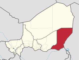
Diffa is one of the seven Regions of Niger, located in the southeast of the country. The capital of the region is Diffa.
Zinder Region is one of the seven regions of Niger; the capital of the region is Zinder. The region covers 145,430 km². It is the most populous province of Niger.
Goure is a Commune and town in southeastern Niger, Zinder Region, Goure Department, of which it is the seat. As of 2012, it had a population of 73,732.
Goudoumaria, Niger is a Commune and town in the southeast of the country, in Diffa Region, northwest of Diffa. Goudoumaria is an administrative post in the Maine-Soroa Department, and is approximately 50 km north of the Nigerian border and approximately 50 km east of the small city Soubdou.

Dosso is a department of the Dosso Region in Niger. Its capital lies at the city of Dosso. As of 2012, the department had a total population of 492,560 people.

Mainé-Soroa is a department of the Diffa Region in Niger. Its capital lies at the city of Mainé-Soroa.
N'guigmi is a department of the Diffa Region in Niger. Its capital lies at the city of N'guigmi. As of 2011, the department had a total population of 77,748 people.
Boboye is a department of the Dosso Region in Niger. Its capital lies at the city of Birni N'Gaouré. As of 2012, the department had a total population of 252,597 people.
Dogondoutchi is a department of the Dosso Region in Niger. Its capital lies at the city of Dogondoutchi. As of 2012, the department had a total population of 372,473 people.
Loga is a department of the Dosso Region in Niger. Its capital lies at the city of Loga. As of 2012, the department had a total population of 175,543 people.

Aguie is a department of the Maradi Region in Niger. Its capital lies at the city of Aguie.
Groumdji is a department of the Maradi Region of Niger. Its capital lies at the city of Guidan Roumdji. As of 2012, the department had a total population of 523,717 people.
Madarounfa is a department of the Maradi Region in Niger. Its capital is Madarounfa. As of 2012, the department had a total population of 448,863 people.

Kollo is a department of the Tillabéri Region in Niger. Its capital lies at the city of Kollo, and includes the towns of N'Dounga, Fakara, Hamdallaye, Karma, Kirtachi, Kouré, Lamordé, Liboré, and Namaro. As of 2012, the department had a total population of 465,399 people.

Goure is a department of the Zinder Region in Niger. Its capital lies at the city of Goure. As of 2012, the department had a total population of 327,818 people.
Magaria is a department of the Zinder Region in Niger. Its capital lies at the city of Magaria. As of 2012, the department had a total population of 577,743 people.
Maiyara is a village and rural commune in Niger. As of 2012, it had a population of 62,441.
Yaouri is a village and rural commune in Matameye Department in Niger.