
Niger is a landlocked nation in West Africa located along the border between the Sahara and Sub-Saharan regions. Its geographic coordinates are longitude 16°N and latitude 8°E. Its area is 1.267 million square kilometers, of which 1 266 700 km2 is land and 300 km2 water, making Niger slightly less than twice the size of France.

Zinder, formerly also spelled Sinder, is the third largest city in Niger, with a population of 235,605 as by the 2012 census. It is situated 861 km (535 mi) east of the capital Niamey and 240 km (150 mi) north of the Nigerian city of Kano.
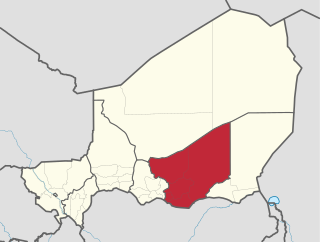
Zinder Region is one of the seven regions of Niger; the capital of the region is Zinder. The region covers 145,430 km². It is the most populous province of Niger.

The Region of Maradi is one of seven regions of Niger. It is located in south-central Niger, east of the Region of Tahoua, west of Zinder, and north of the Nigerian city of Katsina. The administrative centre is at Maradi. The population of the Region is predominantly Hausa.

Tessaoua, formerly known as Tessawa, is a city located in the Maradi Region of Niger. It has a population of 43,409. Tessaoua is historically an important city in its region. It is situated in a central geographical location. Tessaoua is a midpoint on a historical trade route between Agadez, Niger, in the north and Kano, Nigeria, in the south. During the collapse of the sultanates of Bornu and Sokoto during the late 19th century, the local ruler declared his territory the sultanate of Tessaoua; he signed a treaty of protection with the French captain Cazemajou in 1897, prior to the explorer's murder in nearby Zinder.

The Departments of Niger are subdivided into communes. As of 2005, in the seven Regions and one Capital Area, there were 36 départements, divided into 265 communes, 122 cantons and 81 groupements. The latter two categories cover all areas not covered by Urban Communes or Rural Communes, and are governed by the Department, whereas Communes have elected councils and mayors. Additional semi-autonomous sub-divisions include Sultanates, Provinces and Tribes (tribus). The Nigerien government estimates there are an additional 17000 Villages administered by Rural Communes, while there are over 100 Quartiers administered by Urban Communes.
Guidimouni is a town in southern Niger. It is near the city of Zinder. As of 2012, it had a population of 69,587.

Aguie is a department of the Maradi Region in Niger. Its capital lies at the city of Aguie. Among the commune subdivisions within the Department are the "Rural Communes" of Saé Saboua, Arnagou and Giratawa. Nearby villages include Dan Kiri, Dan Gao, Gamji Karama, Dan Rago, Doromawa, Guidan Tonio, and Guidan Kodao.

Goure is a department of the Zinder Region in Niger. Its capital lies at the city of Goure. As of 2011, the department had a total population of 318,861 people.
Magaria is a department of the Zinder Region in Niger. Its capital lies at the city of Magaria. As of 2011, the department had a total population of 696,717 people.
Matameye is a department of the Zinder Region in Niger. Its capital lies at the city of Matameye. The chief town lies 72 km from Magaria. It also includes the town of Kantché. As of 2011, the department had a total population of 345,637 people.
Mirriah is a department of the Zinder Region in Niger. Its capital lies at the city of Mirriah, although its largest city is Zinder. As of 2011, the department had a total population of 1,080,589 people.
Tanout is a department of the Zinder Region in Niger. Its administrative seat is the city of Tanout. As of 2011, the department had a total population of 475,125 people.
Bande, Niger is a village and rural commune in the Magaria Department of the Zinder Region of Niger.
Dogo-Dogo is a village and rural commune in the Dungass Department of the Zinder Region of Niger. As of 2012, it had a population of 65,544.
Gamou is a village and rural commune in the Goure Department of the Zinder Region of Niger.
Gouchi is a village and rural commune in the Dungass Department of the Zinder Region of Niger. As of 2012, it had a population of 71,612.
Kelle, Niger is a village and rural commune in the Goure Department of the Zinder Region of Niger.
Malawa, Niger is a village and rural commune in the Dungass Department of the Zinder Region of Niger. As of 2012, it had a population of 88,954.
Tarka, Niger is a village and rural commune in Niger. It is located in the Belbédji Departement of the Zinder Region. As of 2012 the commune had a population of 96,452.