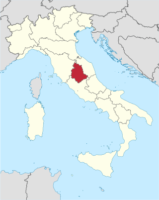
Umbria is a region of central Italy. It includes Lake Trasimeno and Marmore Falls, and is crossed by the Tiber. It is the only landlocked region on the Apennine Peninsula. The regional capital is Perugia.

Città di Castello ; "Castle Town") is a city and comune in the province of Perugia, in the northern part of Umbria. It is situated on a slope of the Apennines, on the flood plain along the upper part of the river Tiber. The city is 56 km (35 mi) north of Perugia and 104 km (65 mi) south of Cesena on the motorway SS 3 bis. It is connected by the SS 73 with Arezzo and the A1 highway, situated 38 km (23 mi) west. The comune of Città di Castello has an exclave named Monte Ruperto within Marche.
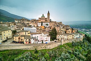
Trevi is an ancient town and comune (municipality) in Umbria, Italy, on the lower flank of Mount Serano overlooking the wide plain of the Clitunno river system. Located in the Province of Perugia, it is 10 km (6 mi) SSE of Foligno and 20 km (12 mi) north of Spoleto. It is one of I Borghi più belli d'Italia.
Umbertide is a town and comune (municipality) in the province of Perugia, in the Italian region of Umbria, at the confluence of the Reggia river and the Tiber. It is 30 km (19 mi) north of Perugia and 20 km (12 mi) south of Città di Castello.

Sassoferrato is a town and comune of the province of Ancona in the Marche region of central-eastern Italy. It is one of I Borghi più belli d'Italia.

Cospaia is an Italian hamlet (frazione) of the comune of San Giustino in the Province of Perugia, Umbria.

Bastia Umbra is a comune (municipality) in the Province of Perugia in the Italian region Umbria, located about 15 km southeast of Perugia. As of 31 December 2004, it had a population of 20,523 and an area of 27.6 km2. Bastia Umbra borders the following municipalities: Assisi, Bettona, Perugia, and Torgiano.

Città della Pieve is a comune (municipality) in the Province of Perugia in the Italian region Umbria, located in Valdichiana a few kilometres from the border between Umbria and Tuscany, and about 50 km (31 mi) southwest of Perugia and 11 km (7 mi) southeast of Chiusi in Tuscany.
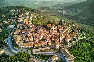
Corciano is a comune (municipality) in the Province of Perugia in the Italian region Umbria, located about 8 km west of Perugia. As of 31 December 2004, it had a population of 17,008 and an area of 63.7 km2. Corciano borders the comuni of Magione and Perugia. It is one of I Borghi più belli d'Italia.

Costacciaro is a comune (municipality) in the Province of Perugia in the Italian region Umbria, located about 40 km northeast of Perugia. It is a medieval burgh, which, after the rule of Perugia and Gubbio, became part of the Papal States in the 15th century.

Fratta Todina is a comune in the Province of Perugia in the Italian region Umbria, located about 30 km south of Perugia.

Monte Castello di Vibio is a comune (municipality) in the Province of Perugia in the Italian region Umbria, located about 30 kilometres (19 mi) south of Perugia. Monte Castello di Vibio borders the following municipalities: Fratta Todina, San Venanzo, Todi.

Pietralunga is a comune (municipality) in the Province of Perugia in the Italian region Umbria, located about 35 km (22 mi) north of Perugia. As of 31 December 2004, it had a population of 2,343 and an area of 140.2 km².

Sigillo is a comune (municipality) in the province of Perugia in the Italian region Umbria, located about 35 km northeast of Perugia.

Ferentillo is a comune (municipality) in the Province of Terni in the Italian region Umbria, located about 60 km southeast of Perugia and about 12 km northeast of Terni. The comune, located in the valley of the Nera, is divided by the river into the burghs of Matterella and Precetto.

Ficulle is a comune (municipality) in the Province of Terni in the Italian region Umbria, located about 40 km southwest of Perugia and about 60 km northwest of Terni.

Lugnano in Teverina is a comune (municipality) in the Province of Terni in the Italian region Umbria, located about 60 km south of Perugia and about 25 km west of Terni.
San Venanzo is a comune (municipality) in the Province of Terni in the Italian region Umbria, located about 30 km (19 mi) southwest of Perugia and about 45 km (28 mi) northwest of Terni.

The Republic of Cospaia was a small state in northern Umbria, now in Italy, that was independent from 1440 to 1826. It was in what is now the hamlet (frazione) of Cospaia, in the municipality (comune) of San Giustino, in the Province of Perugia.

The Villa of Pliny in Tuscis was a large, elaborate ancient Roman villa-estate that belonged to the Plinys. It is located at Colle Plinio near San Giustino, Umbria, Italy.


