Interstate 516 is a 6.49-mile-long (10.44 km) auxiliary Interstate Highway mostly in the coastal city of Savannah, located in the east-central portion of the U.S. state of Georgia. It is a spur route of I-16. For its entire length, I-516 is concurrent with State Route 21 (SR 21), upon which I-516 was designated over in 1985. It was formerly also signed as SR 26 Loop. The highway also carries unsigned State Route 421 (SR 421) to ensure that all Interstates in Georgia had 400-series reference numbers.

The local-express lane system is an arrangement of carriageways within a major highway where long distance traffic can use lanes with fewer interchanges compared to local traffic which use 'local' or 'collector' lanes that have access to all interchanges. This can also be called collector–distributor lanes within a single interchange. Where highway ramps between express and local/collector lanes cross over one another this is commonly known as braided ramps. One of the longest examples is Ontario Highway 401 between Etobiocoke and Pickering in Canada.

California State Route 35, generally known as Skyline Boulevard, is a mostly two-lane road running along the ridge of the Santa Cruz Mountains from the low point of Highway 17 near Lexington Reservoir in Santa Clara County to State Route 1 just south of Daly City in San Mateo County, where it crosses SR 1 and loops around Lake Merced to become Sloat Boulevard in San Francisco.
Merrick Road, known as Merrick Boulevard inside New York City, is an east–west urban arterial in Queens, Nassau, and Suffolk counties, New York, United States. It runs east from the Queens neighborhood of Jamaica through Merrick past the county line between Nassau and Suffolk into Amityville, where it becomes Montauk Highway at the Amityville–Copiague village/hamlet line. The easternmost portion of Merrick Road, from Carman Mill Road to its eastern terminus, signed as part of New York State Route 27A (NY 27A). At one time, the entire length of Merrick Road was signed as NY 27A; currently, the entire portion within Nassau County is currently designated as the unsigned County Route 27 (CR 27). Merrick Road travels along an old right-of-way that was one of the original paths across southern Long Island, stretching from Queens to Montauk Point.
The Grand Central Parkway (GCP) is a 14.61-mile long parkway that stretches from the Triborough Bridge in New York City to Nassau County on Long Island. At the Queens–Nassau border, it becomes the Northern State Parkway, which runs across the northern part of Long Island through Nassau County and into Suffolk County, where it ends in Hauppauge. The westernmost stretch also carries a short stretch of Interstate 278 (I-278). The parkway runs through Queens and passes the Cross Island Parkway, Long Island Expressway, LaGuardia Airport and Citi Field, home of the New York Mets. The parkway is designated New York State Route 907M (NY 907M), an unsigned reference route. Despite its name, the Grand Central Parkway was not named after Grand Central Terminal.

Sepulveda Boulevard is a major street and transportation corridor in the City of Los Angeles and several other cities in western Los Angeles County, California. It is around 42.8 miles (68.9 km) in length, making it the longest street in the city and county of Los Angeles. The Boulevard is known as an area of prostitution.
State Route 47 is a state highway in the U.S. state of California, connecting Terminal Island to the mainland in the Los Angeles area. From its south end at I-110 in San Pedro, it heads east across the Vincent Thomas Bridge to the island and the end of state maintenance. The state highway begins again at the junction with I-710 on Terminal Island, crossing the Schuyler Heim Bridge north to the mainland and the second terminus, where SR 103 begins. Signage continues along a locally maintained route, mainly Alameda Street, to the Gardena Freeway in Compton, and an unconstructed alignment follows the same corridor to the Santa Monica Freeway (I-10) near downtown Los Angeles.

The Richmond Parkway Transit Center or RPTC is a park and ride lot and bus terminal located in Richmond, California. It is named after the adjacent Richmond Parkway. It serves as a transfer point for the WestCAT and AC Transit. It is located on the corner of Richmond Parkway and Blume Drive near the Pinole border and adjacent to Interstate 80 and the Hilltop Plaza shopping center.
Cornell is a new community village being developed in northeast Markham, Ontario and bounded by Highway 407, 16th Avenue, Ninth Line, and the Donald Cousens Parkway. The 2011 population of this area was 9,880. Adding Cornell North's 2,178 it had 12,058 residents.
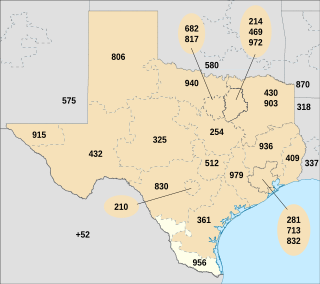
North American area code 956 is a state of Texas telephone area code for numbers in the Brownsville, McAllen, Laredo and South Padre Island areas. It was created May 25, 1997, in a split from area code 210.
U.S. Route 9 is a U.S. highway in the northeast United States, running from Laurel, Delaware north to Champlain, New York. In New Jersey, the route runs 166.80 mi (268.44 km) from the Cape May–Lewes Ferry terminal in North Cape May, Cape May County, where the ferry carries US 9 across the Delaware Bay to Lewes, Delaware, north to the George Washington Bridge in Fort Lee, Bergen County, where the route along with Interstate 95 (I-95) and US 1 continue into New York City. US 9 is the longest U.S. highway in the state. From North Cape May north to Toms River in Ocean County, US 9 is mostly a two-lane undivided road that closely parallels the Garden State Parkway and runs near the Jersey Shore. Along this stretch, it passes through the communities of Rio Grande, Cape May Court House, Somers Point, Pleasantville, Absecon, Tuckerton, Manahawkin, Beachwood and Berkeley Township. In the Toms River area, US 9 runs along the Garden State Parkway for a short distance before heading northwest away from it and the Jersey Shore into Lakewood Township. Upon entering Monmouth County, the route transitions into a multilane suburban divided highway and continues through Howell Township, Freehold Township, Manalapan Township, Marlboro Township, Old Bridge Township, Sayreville, and South Amboy. In Woodbridge Township, US 9 merges with US 1 and the two routes continue through northern New Jersey as US 1/9 to the George Washington Bridge.

White Plains Road is a major north-south thoroughfare which runs the length of the Bronx borough of New York City. It runs from Castle Hill and Clason Point in the south to Wakefield in the north, where it crosses the city line and becomes West 1st Street of Mount Vernon, New York. The Bronx River Parkway lies to its west and parallels much of its route. Between Magenta Street & 217th Street, White Plains Road is very wide due to the presence of the Gun Hill Road station house in the road's median.

The University District, often referred to as University Parkway, is a foothill community located approximately 5–8 miles north of downtown San Bernardino, California. The District is named after the California State University, San Bernardino. It is one of the most desirable neighborhoods in San Bernardino along with the Hospitality Lane District. As California State University, San Bernardino grew so did the region around it; it used to be nothing but mid-desert farmland, but has been developing quickly to become a major and important independent neighborhood to not only San Bernardino but also the entire region.
There are 34 routes assigned to the "S" zone of the California Route Marker Program, which designates county routes in California. The "S" zone includes county highways in Imperial, Orange, Riverside, San Diego, and Santa Barbara counties.
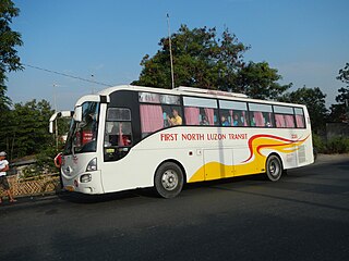
First North Luzon Transit, Incorporated (FNLT), or simply known as First North Luzon is a bus company in the Philippines. They started their operations in Hagonoy, Bulacan, and expanded to San Isidro, Nueva Ecija, Bulacan, Pampanga, Bataan, Pangasinan and La Union.


