
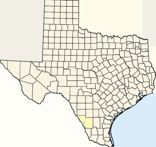
Brown County is a county in west-central Texas. As of the 2010 census, the population was 38,106. Its county seat is Brownwood. The county was founded in 1856 and later organized in 1858. It is named for Henry Stevenson Brown, a commander at the Battle of Velasco, an early conflict between Texians and Mexicans.

The Republic of the Rio Grande was an independent nation that insurgents against the Central Mexican Republic sought to establish in northern Mexico. The Republic of the Rio Grande was just one of a series of independence movements in Mexico under the unitary government dominated by Santa Anna, including the Republic of Texas, the Republic of Zacatecas, and the Republic of Yucatán. The rebellion lasted from January 17 to November 6, 1840.

The Roman Catholic Diocese of Laredo is a Roman Catholic diocese located in Laredo, Texas. It was founded on July 3, 2000. The San Agustin Cathedral is the Mother Church of the Diocese of Laredo. James Anthony Tamayo is the current bishop of the Diocese. It covers an area of 10,905 sq. mi. and has 289,415 members. It has 52 priests, 32 deacons, 32 parishes, and 17 missions.
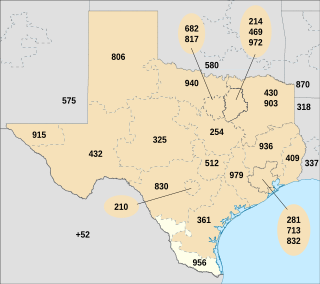
North American area code 956 is a state of Texas telephone area code for numbers in the Brownsville, McAllen, Laredo and South Padre Island areas. It was created May 25, 1997, in a split from area code 210.

Farm to Market Road 1472 is a farm-to-market road that connects the Laredo, Texas Industrial Area to the Colombia – Solidarity International Bridge, then running roughly parallel to the Rio Grande into rural Webb County. In the urban sections of Laredo, it is a six-lane route known locally as Mines Road.
Laredo College (LC) is a public college in Laredo, Texas. Founded as Laredo Junior College in 1947, it is part of the Laredo Independent School District. As defined by the Texas Legislature, the official service area of LC includes the municipality of Laredo and all of Webb, Jim Hogg and Zapata counties.
Santo Tomás was a coal-mining town near Laredo in west central Webb County, Texas, United States. The town was founded in 1801 by Antonio Gonzales and was named in honor of Saint Thomas. During the colonial era the land was used primarily for ranching. Pure quality cannel coal was found and extracted in 1873. In June 1882, the narrow-gauge Rio Grande and Pecos Railroad was built to transport the coal. By 1900, the town grew and had a population of approximately 1,000. By 1920, all the mines closed and the population of Santo Tomás decreased to 18. Today, Santo Tomás is a ghost town near the Colombia-Solidarity International Bridge.
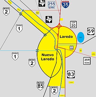
The Laredo–Nuevo Laredo Metropolitan Area is one of six bi-national metropolitan areas along the U.S.-Mexican border. The city of Laredo is situated in the U.S. state of Texas on the northern bank of the Rio Grande and Nuevo Laredo is located in the Mexican State of Tamaulipas in the southern bank of the river. This metropolitan area is also known as the Two Laredos or the Laredo Borderplex. The metropolitan area is made up of one county: Webb County in Texas and three municipalities: Nuevo Laredo Municipality in Tamaulipas, Hidalgo Municipality in Coahuila, Anáhuac Municipality in Nuevo León in Mexico. Two urban areas: the Laredo Metropolitan Statistical Area and the Zona Metropolitana Nuevo Laredo three cities and 12 towns make the Laredo–Nuevo Laredo Metropolitan area which has a total of 636,516 inhabitants according to the INEGI Census of 2010 and the United States Census estimate of 2010. The Laredo–Nuevo Laredo is connected by four International Bridges and an International Railway Bridge. According to World Gazetteer this metropolitan area ranked 157th largest in North and South America in 2010 with an estimated population of 775,481. This area ranks 66th in the United States and 23rd in Mexico.
The Municipality of Nuevo Laredo is located in the Mexican state of Tamaulipas. Its municipal seat is Nuevo Laredo. The municipality contains more than 60 localities which the most important ones are Nuevo Laredo, El Campanario y Oradel, and Álvarez, the last two being suburbs of the city of Nuevo Laredo. By population, the municipality is the third largest in the state of Tamaulipas. The Nuevo Laredo municipality is the northernmost in Tamaulipas, lying at the extreme northwestern tip of its narrow strip of land along the Río Grande. The city of Nuevo Laredo contains approximately 97.5% of the total population of the municipality.
Downtown Laredo is the second main business district in Laredo, Texas. Downtown Laredo is the starting point for Interstate Highway 35 and State Highway 359. It is home to all of Laredo's high-rise buildings. Laredo's and Webb County's main government buildings are located in Downtown Laredo. Most of Webb County's National Register of Historic Places are in this area.
Chacon Creek is a small stream of water located in Webb County, Texas, USA, which runs through Laredo. The creek is formed 6 miles from Webb and runs southwest for 20 miles until it connects to the Rio Grande. Chacon was dammed in 1951 in east Laredo to form Lake Casa Blanca, a 1,680 acres (6.8 km²) lake. The terrain surrounding the creek is mostly clay. The vegetation surrounding the creek is mostly made up of mesquite, cacti and grasses. Chacon Creek is cross by several highways in Laredo, including United States Route 59, Texas State Highway Loop 20, Texas State Highway Spur 400, Texas State Highway 359 and United States Route 83

Zacate Creek is inside Laredo, Texas city limits and runs southwest for 10 miles until it connects to the Rio Grande. Zacate Creek has several ditches leading to it. The terrain surrounding the creek is mostly clay. The vegetation surrounding the creek is mostly made up of mesquite, cacti, and grasses. Zacate Creek and branches cross several highways in Laredo, Texas among them are: Interstate 35, United States Route 59, Texas State Highway Spur 400, Texas State Highway 359, and United States Route 83. The northern branch of the Zacate Creek has a small dam which formed a pond located in Northeast Laredo which is usually filled during storms. The city of Laredo has developed the Zacate Creek Park and the Zacate Creek Greenway, a three mile trail near the creek.
San Idelfonso Creek is a small stream of water located in Webb County, Texas which runs through Laredo, Texas. The creek is formed within east Laredo and runs southwest for 8 miles until connecting to the Rio Grande. San Ildefonso Creek was dammed in east Laredo to form San Ildefonso Creek Lake, the second largest Lake in Laredo. The terrain surrounding the creek is mostly clay and sandy loams. The vegetation surrounding the creek is mostly made up of mesquite, cacti, chaparral, hardwoods and grasses. San Idelfonso Creek crosses two major highways in Laredo, Texas among them are: Texas State Highway 359 and United States Route 83
Sombrerillito Creek is a small stream of water located in Webb County, Texas which runs through Laredo, Texas. The creek is formed 13 miles north of Laredo and runs southwest for 16 miles until connecting to the Rio Grande. Sombrerillito Creek was dammed in northwest Laredo to form Sombrerillito Creek Lake, the third largest lake in Laredo. The terrain surrounding the creek is mostly clay and sandy loams. The vegetation surrounding the creek is mostly made up of mesquite, cacti, chaparral, hardwoods and grasses. Sombrerillito Creek crosses one major highway in Laredo, Texas among them are: Farm to Market Road 1472.
San Ygnacio Creek is a small stream of water located in Webb County, Texas which runs through Laredo, Texas. The creek is formed 11 miles northwest of Laredo, Texas and runs southwest for 12 mi (19 km) until the creek connects to the Lake Casa Blanca. The terrain surrounding the creek is mostly clay. The vegetation surrounding the creek is mostly made up of mesquite, cacti, and grasses. San Ygnacio Creek does not cross any major highway.

El Azteca is one of the oldest and most intact residential neighborhoods in Laredo, Texas, with buildings dating from the 1870s representing nearly every major architectural type and style that has appeared on the border since that time.
Interstate 69W (I-69W) is a relatively short north–south Interstate Highway running through South Texas in the United States. The freeway begins northeast of the middle of World Trade International Bridge in Laredo and ends at I-35. In the future, I-69W will head northeast for 180 miles (290 km) before terminating near Victoria as both I-69E and I-69W merge to form I-69. For its entire length, I-69W runs concurrently with US Highway 59 (US 59).
The following is a timeline of the history of the city of Laredo, Texas, USA.
Rio Grande Detention Center is a privately owned prison for men located in Laredo, Webb County, Texas, operated by GEO Group under contract with the U.S. government Office of the Federal Detention Trustee. The prison was originally built in 2007, opened in 2008, and has an official capacity of 1900 federal detainees awaiting trial.


