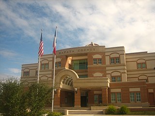
Zapata County is a county located in the U.S. state of Texas. As of the 2010 census, its population was 14,018. Its county seat is Zapata. The county is named for Colonel Jose Antonio de Zapata, a rancher in the area who rebelled against Mexico.

San Ygnacio is a census-designated place (CDP) in Zapata County, Texas, in the United States. As of the 2010 census, the CDP population was 667. It is named for the prominent Spanish saint, Ignatius of Loyola. The portion of the community between the Rio Grande and U.S. Highway 83 is listed on the National Register of Historic Places as San Ygnacio Historic District.

The Roman Catholic Diocese of Laredo is a Roman Catholic diocese located in Laredo, Texas. It was founded on July 3, 2000. The San Agustin Cathedral is the Mother Church of the Diocese of Laredo. James Anthony Tamayo is the current bishop of the Diocese. It covers an area of 10,905 sq. mi. and has 289,415 members. It has 52 priests, 32 deacons, 32 parishes, and 17 missions.
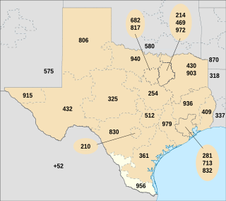
North American area code 956 is a state of Texas telephone area code for numbers in the Brownsville, McAllen, Laredo and South Padre Island areas. It was created May 25, 1997, in a split from area code 210.
Nye was a town two miles north of Laredo in southwestern Webb County, Texas, United States. It was named after Thomas C. Nye, a local planter who introduced Bermuda onions into the community in 1898. The area has been eventually absorbed by neighboring Laredo.
Casa Blanca was an unincorporated community two miles (3 km) southwest of Sandia and twenty miles (32 km) northeast of Alice in extreme northeastern Jim Wells County, Texas, United States.
Radcliffe Killam was a wealthy oilman, rancher, businessman, and philanthropist in Laredo, the seat of Webb County in south Texas. He was a particular benefactor of various educational and medical institutions. In 1997, Worth cited the Killam family as one of the largest landowners in the United States, with 200,000 acres (810 km2). Part of that includes the 125,000-acre (510 km2) Duval County Ranch west of Freer, which Killam purchased in 1994.
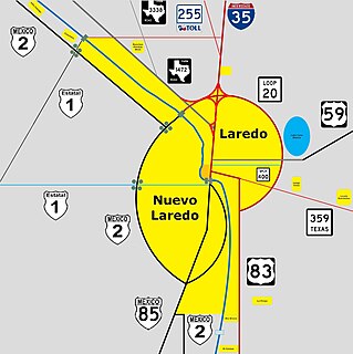
Downtown Laredo is the second main business district in Laredo, Texas. Downtown Laredo is the starting point for Interstate Highway 35 and State Highway 359. It is home to all of Laredo's high-rise buildings. Laredo's and Webb County's main government buildings are located in Downtown Laredo. Most of Webb County's National Register of Historic Places are in this area.
Callaghan is a ranching community in Webb County, Texas and was established in 1881. The community was named after a nearby ranch owned by Charles Callaghan and much later Joe B. Finley. The community was once a cattle shipping point on the International and Great Northern Railroad. Callaghan is served by the Callaghan Ranch Airport. Callaghan is fourteen miles north of Laredo, Texas.
Chacon Creek is a small stream of water located in Webb County, Texas, USA, which runs through Laredo. The creek is formed 6 miles from Webb and runs southwest for 20 miles until it connects to the Rio Grande. Chacon was dammed in 1951 in east Laredo to form Lake Casa Blanca, a 1,680 acres (6.8 km²) lake. The terrain surrounding the creek is mostly clay. The vegetation surrounding the creek is mostly made up of mesquite, cacti and grasses. Chacon Creek is cross by several highways in Laredo, including United States Route 59, Texas State Highway Loop 20, Texas State Highway Spur 400, Texas State Highway 359 and United States Route 83

Zacate Creek is inside Laredo, Texas city limits and runs southwest for 10 miles until it connects to the Rio Grande. Zacate Creek has several ditches leading to it. The terrain surrounding the creek is mostly clay. The vegetation surrounding the creek is mostly made up of mesquite, cacti, and grasses. Zacate Creek and branches cross several highways in Laredo, Texas among them are: Interstate 35, United States Route 59, Texas State Highway Spur 400, Texas State Highway 359, and United States Route 83. The northern branch of the Zacate Creek has a small dam which formed a pond located in Northeast Laredo which is usually filled during storms. The city of Laredo has developed the Zacate Creek Park and the Zacate Creek Greenway, a three mile trail near the creek.
San Idelfonso Creek is a small stream of water located in Webb County, Texas which runs through Laredo, Texas. The creek is formed within east Laredo and runs southwest for 8 miles until connecting to the Rio Grande. San Ildefonso Creek was dammed in east Laredo to form San Ildefonso Creek Lake, the second largest Lake in Laredo. The terrain surrounding the creek is mostly clay and sandy loams. The vegetation surrounding the creek is mostly made up of mesquite, cacti, chaparral, hardwoods and grasses. San Idelfonso Creek crosses two major highways in Laredo, Texas among them are: Texas State Highway 359 and United States Route 83
Sombrerillito Creek is a small stream of water located in Webb County, Texas which runs through Laredo, Texas. The creek is formed 13 miles north of Laredo and runs southwest for 16 miles until connecting to the Rio Grande. Sombrerillito Creek was dammed in northwest Laredo to form Sombrerillito Creek Lake, the third largest lake in Laredo. The terrain surrounding the creek is mostly clay and sandy loams. The vegetation surrounding the creek is mostly made up of mesquite, cacti, chaparral, hardwoods and grasses. Sombrerillito Creek crosses one major highway in Laredo, Texas among them are: Farm to Market Road 1472.
Santa Isabel Creek is a small stream of water located in Webb County, Texas which runs through Laredo, Texas. The creek is formed 32 miles from Callaghan, Texas and runs southwest for 33 mi (53 km) until the creek connects to the Rio Grande. The terrain surrounding the creek is mostly clay. The vegetation surrounding the creek is mostly made up of mesquite, cacti, and grasses. Santa Isabel Creek crosses Three major highways in Laredo, Texas among them are: Farm to Market Road 1472, Texas State Highway 255, and United States Route 83.
Laredo Ranchettes West is a census-designated place (CDP) in Webb County, Texas, United States. This was a new CDP formed from parts of the Laredo Ranchettes CDP prior to the 2010 census. Although a new CDP the population was listed as zero.
San Carlos I is a census-designated place (CDP) in Webb County, Texas, United States. This was a new CDP formed from parts of the Laredo Ranchettes CDP prior to the 2010 census with a population of 316.
San Carlos II is a census-designated place (CDP) in Webb County, Texas, United States. This was a new CDP formed from parts of the Laredo Ranchettes CDP prior to the 2010 census with a population of 261.


