Amatlán de Cañas is a municipality and municipal seat in the southwest of the Mexican state of Nayarit. The population in 2005 was 10,392 in a total area of 765 km², which made up 2.77% of the surface of the state. The municipal seat had a population of 3,275 in 2005.
El Nayar is a municipality in the Mexican state of Nayarit. The population was 30,551 in 2005 in a total area of 5,100 km². The municipal seat of Jesús María had a population of 1,520 in 2005. El Nayar is the home of the Huichol, Cora, and the Tepehuán Indians.
Jala is both a municipality and a town in the Mexican state of Nayarit. As of 2005, the population of the municipality was 16,071, in a total area of 364.60 square kilometers. The population of the municipal seat of the same name was 9,631.
La Yesca is a municipality and the municipal seat of the same in the Mexican state of Nayarit. The population of the municipality was 12,025 (2005). The population of the town and municipal seat was 356 inhabitants in 2005. The population density was 7 inhabitants per square kilometer, one of the lowest in the state.
Xalisco is a city and its surrounding municipality of the same name in the Mexican state of Nayarit. The city had a population of 21,899 in the 2005 census while the municipality has an area of 290.6 km2 and a population of 42,893. The municipality lies adjacent to the south side of Tepic, the state capital, and is part of the Tepic metropolitan area.
Rosamorada is a municipality of the state of Nayarit in Mexico. It is located in the middle of the state. The area of the municipality is 2,073 km2 and the population was 32, 217 in 2005, showing a significant decrease from 1980 when it was 34,695. Most of the population is still rural with the major settlements being Rosamorada with 3,393 inhabitants; San Vicente with 4,556; Los Pericos with 2,441; Chilapa with 2,277; Pimientillo with 1,824 and El Tamarindo with 1,544.

Uriangato is a city and one of 46 municipalities of Guanajuato, located just north of the border between the states of Guanajuato and Michoacán in west central Mexico. Uriangato city is geographically united with Moroleon city and Yuriria city, these three cities form a metropolitan area. Since October 2010, this metropolitan area is the 75th biggest city of Mexico and the 5th biggest in Guanajuato. It is smallest of the 56 metropolitan areas in Mexico.

Encarnación de Díaz is a town and municipality located in the far northeast of the state of Jalisco in north-central Mexico. It is located in a natural pass that connects the Los Altos region of Jalisco to points north, and from pre-Hispanic times until the 20th century, it was a major thoroughfare for north-south travel. The town began as a way station along a road built through this pass in the 17th century, formally becoming a town in 1760. It began to function as a municipality in the latter 19th century, but this status was not confirmed until the early 20th. Transport, along with numerous prosperous haciendas supported the economy of the area until the early 20th century, when travel patterns and the Mexican Revolution spurred its decline. In the 1920s, it was a centre of rebellion during the Cristero War, and the town contains Mexico's only museum exclusively dedicated to this episode in history. It also contains a museum dedicated to various naturally occurring mummies which have been found in the municipal cemetery.
Ruiz is a municipality and the municipal seat of the same located in the north of the Mexican state of Nayarit.

Santiago de Ixcuintla is a municipality and a municipal seat in the western Mexican state of Nayarit. The municipal population was 84,314 inhabitants with the municipal seat having 18,269. The area of the municipality was 1,831.92 square kilometers. It is located at 21º48'40" N and 105º12'23" W.

Ahuacatlán is both a municipality and a municipal seat in the Mexican state of Nayarit. The municipal seat had a population of 8,819 in 2005.
Tuxpan, is both a municipality and a municipal seat in the Mexican state of Nayarit. It is located in the west of the state and has boundaries with the municipalities of Rosamorada in the north, Santiago Ixcuintla in the south and west, and Ruiz in the east.

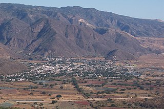
Santa María del Oro is a municipality and municipal seat in the Mexican state of Nayarit. It is located in the south of the state and has boundaries with the municipalities of El Nayar, Tepic, Ahuacatlán, Jala, San Pedro Lagunillas, La Yesca, and Xalisco. The population was 21,688 in 2005, with the municipal seat of the same name having 3,314 inhabitants. The total area was 912.90 km2.

Jerécuaro is a Mexican city located in the lowlands of the state of Guanajuato. The municipality has an area of 828.3 square kilometres and is bordered to the north by Apaseo el Alto, to the east by Coroneo and the state of Querétaro, to the south by Tarandacuao, to the southwest with Acámbaro, and to the northwest with Tarimoro. The municipality had 55,311 inhabitants according to the 2005 census. The municipal president of Jerécuaro and its many smaller outlying communities is C.Jaime García Cardona.
Temoaya is a municipality in the State of Mexico, Mexico. It's municipal seat is the town of Temoaya which is the sixth largest town in the municipality. It is located 18 kilometres (11 mi) from Toluca and 85 kilometres (53 mi) from Mexico City. It is known for its large ethnic Otomi population, the Centro Ceremonial Otomí and its tradition of making Persian style rugs using Mexican designs.
Tlatlaya is one of 125 municipalities of the State of Mexico in Mexico. The municipal seat is the town of Tlatlaya which is the eleventh largest town in the municipality. The word “Tlatlaya” means when the hearth is black and red.
The municipality of Lagunillas is a municipality in the Mexican state of Michoacán. Its municipal seat is Lagunillas, Michoacán. It is bordered on the north and east by Morelia, south and west with Huiramba and Tzintzuntzan. Its distance from the state capital is 30 kilometers by the federal highway Morelia-Patzcuaro number 14. Lagunillas owes its name to the system of lakes and ponds that existed in ancient times in the region. During the colony a population center type hacendario. This place was called “Hacienda de Lagunillas”. By running the years the economic and social life revolved around the farm until the year of 1930 when “La Reforma Agraria” took place.
Tzintzuntzan Municipality is a municipality in the Mexican state of Michoacán. The seat is Tzintzuntzan, Michoacán.
San Sebastián Nicananduta is a town and municipality in Oaxaca in south-western Mexico. The municipality covers an area of km2. It is part of the Teposcolula District in the center of the Mixteca Region

Allende Municipality is a municipality located in the northeastern Mexican state of Nuevo León. It comprises a region known as Región Citrícola, for being a major producer of orange at local, national and even international level. Allende is located at the Sierra Madre Oriental range foothills in the central-southeastern part in the state of Nuevo León. It has a territorial extension of 148.5 km2, comprising around 0.22% of the whole extension of Nuevo León. Given its geographic location, the region consists of valleys and hills ranging from 300 meters above sea level on the northeast, to 1,640 meters above sea level in the southwestern part of the municipality. According to the 2010 census data, it had a population of 32,581, of whom 16,436 were men and 16,145 were women. The main economic activities are agriculture, livestock, beekeeping, poultry and transportation, activities that generate many jobs in the region. A sister city of Allende is Conroe, Texas.