External links
- Enciclopedia de los Muncipios de Mexico
- Information about the mines
- Arrest of dangerous criminal in La Yesca
21°19′N104°00′W / 21.317°N 104.000°W
Tepic (capital) | ||
| Municipalities and municipal seats |
|  |
| Protected areas | ||
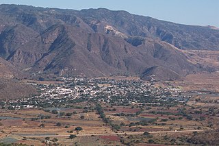
La Yesca is a municipality and the municipal seat of the same in the Mexican state of Nayarit. The population of the municipality was 12,025 (2005). The population of the town and municipal seat was 356 inhabitants in 2005. The population density was 7 inhabitants per square kilometer, one of the lowest in the state.
The name is derived from a species of porous and soft wood called "yesca" (English: tinder), which is found in the area.
La Yesca municipality covers 4,316.311 square kilometres (1,666.537 sq mi), having the second largest area for municipalities in Nayarit. [1] Located at the southern end of the Sierra Madre Occidental, it is mostly mountainous terrain. It lies between 21º 10’ and 22º 00’ North latitude and 103º 43” and 104º 33’ west longitude. It is bordered to the southwest by the municipalities of Santa María del Oro, Jala and Ixtlán del Río, to the northwest by the municipality of El Nayar, and to the north, east and south by the state of Jalisco. [1] [2]
Mountainous zones comprise 95% of the area. The main elevations are Sierra el Pinabete at 1,420 m, the Sierra Pajaritos with an elevation of 2,500 m and the Sierra de Álica with an elevation of 2,200 m.
The rivers are: the Río Grande de Santiago, Bolaños, Camotlán, Huaynamota and Jora Viejo.
La Yesca has vast forest and mineral resources, as well as pastures for extensive cattle raising.
The soil is generally rocky, eroded and with few lands for agriculture.
The census of 1995 registered 4,350 indigenous inhabitants, which made up 35.92% of the population. La Yesca had the second largest indigenous population in the state after El Nayar.
The road system is precarious and the main means of transport is by plane.
The economy is based on agriculture, which is almost all seasonal. Most of the planted area is used for corn. Cattle raising is the main activity of the municipality and there were more than 80,000 head in 1995.
There is at least one active mine for gold and silver located on a 6 km2 concession. The project includes two previous producing mines and a modern milling facility capable of milling 200 tonnes per day of feed. Approximately 200,000 tonnes of tailings are available to process immediately, with the tailings containing good grades of both gold and silver. [3]
La Yesca is the main processor of pine wood in the state. It produced 41% of the state total in 1995.
21°19′N104°00′W / 21.317°N 104.000°W
Tepic (capital) | ||
| Municipalities and municipal seats |
| |
| Protected areas | ||

Durango, officially named Estado Libre y Soberano de Durango, is one of the 31 states which make up the 32 Federal Entities of Mexico, situated in the northwest of the country. With a population of 1,832,650, the 8th lowest of Mexico's states, Durango has Mexico's second-lowest population density, after Baja California Sur. The capital city, Victoria de Durango, is named after the first President of Mexico, Guadalupe Victoria.

Nayarit, officially the Free and Sovereign State of Nayarit, is one of the 31 states that, along with Mexico City, comprise the Federal Entities of Mexico. It is divided in 20 municipalities and its capital city is Tepic.
Nayarit is a state in West Mexico, divided into twenty municipalities. According to the 2020 Mexican Census, it is the fourth least populated state with 1,235,456 inhabitants and the 23rd largest by land area spanning 27,856.5 square kilometres (10,755.5 sq mi).

The Río Grande de Santiago, or Santiago River, is a river in western Mexico. It flows westwards from Lake Chapala via Ocotlán through the states of Jalisco and Nayarit to empty into the Pacific Ocean. It is one of the longest rivers in Mexico, measuring up 433 km (269 mi) long.
Amatlán de Cañas is a municipality and municipal seat in the southwest of the Mexican state of Nayarit. The population in 2005 was 10,392 in a total area of 765 km², which made up 2.77% of the surface of the state. The municipal seat had a population of 3,275 in 2005.
El Nayar is a municipality in the Mexican state of Nayarit. The population was 30,551 in 2005 in a total area of 5,100 km². The municipal seat of Jesús María had a population of 1,520 in 2005. El Nayar is the home of the Huichol, Cora, and the Tepehuán Indians.
Jala is both a municipality and a town in the Mexican state of Nayarit. As of 2005 the population of the municipality was 16,071, in a total area of 364.60 square kilometers. The population of the municipal seat of the same name was 9,631.
Jesús María is the municipal seat of the municipality of El Nayar in the Mexican state of Nayarit in Mexico. The population was 1,783 in 2000.

Compostela is the name of both a municipality and of a town in it that serves as the seat; both are in the Mexican state of Nayarit. The municipality had 62,925 in a total area of 1,848 km². The town and its municipal seat had a population of 15,991 in 2000.
San Pedro Lagunillas is both a municipality and the municipal seat of the same in the Mexican state of Nayarit. The population of the municipality was 7,155 (2005) in a total area of 520 square kilometers. The population of the town and municipal seat was 3,630 (2005). The population has been declining since 1980 when it was 8,308 inhabitants.
Rosamorada is a municipality of the state of Nayarit in Mexico. It is located in the extreme north of the state. The area of the municipality is 2,073 km² and the population was 32, 217 in 2005, showing a significant decrease from 1980 when it was 34,695. Most of the population is still rural with the major settlements being Rosamorada with 3,393 inhabitants; San Vicente with 4,556; Los Pericos with 2,441; Chilapa with 2,277; Pimientillo with 1,824 and El Tamarindo with 1,544.
Ruiz is a municipality and the municipal seat of the same located in the north of the Mexican state of Nayarit.

Ixtlán del Río is both a municipality and the municipal seat in the Mexican state of Nayarit. In 2018, the population of the municipality was 33,289, with 35,180 residents living in the municipal seat. The total area of the municipality is 581.4 km².

Santa María del Oro is a municipality and municipal seat in the Mexican state of Nayarit. It is located in the south of the state and has boundaries with the municipalities of El Nayar, Tepic, Ahuacatlán, Jala, San Pedro Lagunillas, La Yesca, and Xalisco. The population was 21,688 in 2005, with the municipal seat of the same name having 3,314 inhabitants. The total area was 912.90 km².

Bacoachi is a small town in Bacoachi Municipality in the north of the Mexican state of Sonora. The area of the municipality is 487 square miles (1,260.65 km²) and the population was 1,456 in 2005, with 924 inhabitants residing in the municipal seat. The elevation of the municipal seat is 4,429 feet above sea level.
Huepac is the seat of a Huépac Municipality in the center of the Mexican state of Sonora. The municipal area is 317.37 km² with a population of 1,142 registered in 2000. Most of the inhabitants live in the municipal seat.

Nacozari de García is a small mining town surrounded by the Nacozari de García Municipality in the northeast of the Mexican state of Sonora.

Llera de Canales is a municipality located in the Mexican state of Tamaulipas. Also called Llera, the municipality has an area of 2,307 square kilometres (891 sq mi) and a 2010 population of 17,333. The population of the town of Llera is 4,148. Llera was founded December 25, 1748 and later renamed Llera de Canales.

La Manzanilla de La Paz is a town and municipality, in Jalisco in central-western Mexico. The municipality covers an area of 134 km². As of 2020, the municipality had a total population of 4,099.

The Pajarito Mountains are a small mountain range at the southern end of the Sierra Madre Occidental. They are located in the state of Nayarit in western Mexico.