Compostela | |
---|---|
Rincón de Guayabitos | |
![]() Location of Compostela municipality in Nayarit | |
Coordinates: 21°14′20″N104°54′00″W / 21.23889°N 104.90000°W | |
Country | Mexico |
State | Nayarit |
Founded | 1530 |
Founded by | Nuño de Guzmán |
Seat | Compostela |
Government | |
• Presidente municipal | Romina Chang Aguilar (Morena ![]() |
Area | |
• Municipality | 823.6 km2 (318.0 sq mi) |
Highest elevation | 30 m (100 ft) |
Population | |
• Municipality | 37,478 |
• Density | 46/km2 (120/sq mi) |
• Urban | 10,187 |
Time zone | UTC-7 (MST (Zona Pacífico)) |
• Summer (DST) | UTC-6 (MDT (Zona Pacífico)) |
Postal Code | 63740 |
Area Code | 323, 327, |
Website | compostela |
Compostela is the name of both a municipality and of a town in it that serves as the seat; both are in the Mexican state of Nayarit. The municipality had 62,925 (2005 census) in a total area of 1,848 km² (713.5 sq mi). The town and its municipal seat had a population of 15,991 in 2000.
The name was given in honor of Santiago de Compostela in Galicia, Spain; tradition says that "Compostela" comes from Latin campus stellae, "field of stars" (another theory makes it come from composita tella or even compositella).
Compostela is located on the south coast of the state and is bounded in the north by San Blas and Xalisco; in the south by Bahía de Banderas and the state of Jalisco; in the east by Santa María del Oro, San Pedro Lagunillas and the state of Jalisco; in the west by the Pacific Ocean.
The largest settlements in the municipality are: Compostela (15,991 inhabitants in 2000), Las Varas (12,403), La Peñita de Jaltemba (7,062), Zacualpan (4,468), and Colonia Paraíso Escondido (2,069).
The climate is tempered by elevation, with rains from July to September. The hottest months are April and May. The average annual rainfall is 968.5 mm. The average annual temperature is 22.9 °C.
The economy is heavily based on agriculture. The main crops are tobacco, corn, beans, coffee, sorghum, and mangoes. There were around 50,000 head of cattle in 1995. There were several small gold and silver mines. In manufacturing the main products were cigars, mango packing, rice shelling, soap factories, cattle feed, furniture, and food and drink.
This is a region that attracts a considerable number of local and foreign visitors due to the natural landscape, beaches, historical sites and the international fishing competitions.
Around Las Varas in the direction of the south there are beaches in the zone called Costa Alegre, among which should be mentioned: Chacala and Chacalilla, La Peñita de Jaltemba, Rincón de Guayabitos, Los Ayala, El Monteón, Lo de Marcos and Playa Platanitos, as well as the islands in the bay of Rincón de Guayabitos, with a good infrastructure of services.
Municipal president | Term | Political party | Notes |
Petronilo Díaz Ponce [1] | 1917 | ||
Manuel Pimienta Hernández | 1918 | ||
Rafael Dávila | 1919 | ||
José Ma. Regalado Larios | 1920–1921 | ||
Fernando Romero Paredes | 1922–1923 | ||
Gustavo Luna Plata | 1924 | ||
Pedro Ibarra Trujillo | 1925 | ||
Gustavo Luna Plata | 1926 | ||
Rafael Ibarra Trujillo | 1927 | ||
Alberto Rodríguez Rocha | 1928 | ||
Rafael Ibarra Trujillo | 1929 | ||
Narciso Piña | 1930 | PNR ![]() | |
Gustavo B. Maciel | 1931 | PNR ![]() | |
Apolonio Aguirre Delgado | 1931 | PNR ![]() | |
Jorge Olimón Colio | 1932–1933 | PNR ![]() | |
Juan Manuel Larios | 1934 | PNR ![]() | |
Guillermo Flores Abena | 1935 | PNR ![]() | |
Joaquín Betancourt | 1935 | PNR ![]() | |
Jesús Puga Flores | 1936 | PNR ![]() | |
Alfonso Ocegueda Carrillo | 1937–1938 | PNR ![]() | |
Isidro Mora Piña | 1938 | PRM ![]() | |
Alfonso Rodríguez Aguirre | 1939–1940 | PRM ![]() | |
Reyes Orozco Villa | 1941 | PRM ![]() | |
Pedro Arciniega Álvarez | 1941–1942 | PRM ![]() | |
Eduardo Arcadia Mediana | 1943–1944 | PRM ![]() | |
Martiniano Trejo González | 1945–1948 | PRM ![]() PRI ![]() | |
Fernando Ulloa González | 1949–1951 | PRI ![]() | |
Martiniano Trejo González | 1952–1954 | PRI ![]() | |
Juan Gradilla Vidriales | 1955–1958 | PRI ![]() | |
Salvador Gutiérrez Contreras | 1958–1960 | PRI ![]() | |
Manuel Gradilla Muñoz | 1961–1963 | PRI ![]() | |
Indalencio Esparza | 1963 | PRI ![]() | Acting municipal president |
Raymundo Zavala Sánchez | 1964–1966 | PRI ![]() | |
Rafael Machuca Medina | 1967–1969 | PRI ![]() | |
Juan Hernández García | 1969–1971 | PRI ![]() | |
Javier Ayón Uribe | 1970–1972 | PRI ![]() | |
Ángel Ocegueda Cuevas | 1973–1975 | PRI ![]() | |
Juan Manuel Inda Vallejo | 1976–1978 | PRI ![]() | |
Nicolás Aguirre Anzaldo | 1978–1979 | PRI ![]() | |
Enrique Medina Lomelí | 1979–1981 | PRI ![]() | |
Alejandro González Sánchez | 1981–1982 | PRI ![]() | |
Ramón Pimienta Aguirre | 1982–1984 | PRI ![]() | |
Arnulfo Peña Banda | 1984–1987 | PRI ![]() | |
Heriberto Conde Valdés | 1987–1990 | PRI ![]() | |
Macario Aguayo Durán | 1990–1992 | PRI ![]() | |
José Luis Flores de los Ángeles | 1992–1993 | PRI ![]() | |
Baltazar Cruz Dueñas | 1993–1996 | PRI ![]() | |
Andrés Villaseñor Salazar [2] | 17-09-1996–16-09-1999 | PRI ![]() | |
Juan Aguirre Chávez [3] | 17-09-1999–16-09-2002 | PRI ![]() | |
Alicia Monroy Lizola [4] | 17-09-2002–16-09-2005 | PRI ![]() | |
Marco Antonio Moreno Venegas [5] | 17-09-2005–16-09-2008 | PRI ![]() | |
Héctor López Santiago [6] | 17-09-2008–16-09-2011 | PRI ![]() Panal ![]() | Coalition "For the Nayarit We All Want" |
Pablo Pimienta Márquez [7] | 17-09-2011–16-09-2014 | PAN ![]() | |
Alicia Monroy Lizola [8] | 17-09-2014–16-09-2017 | PRI ![]() Panal ![]() PVEM ![]() | Coalition "For the Good of All" |
Gloria Núñez Sánchez [9] [10] [11] | 17-09-2017–27-03-2018 | PAN ![]() PRD ![]() PT ![]() PRS ![]() | Coalition "Together for You". She was elected constitutional municipal president of Compostela. Applied for a temporary leave to run in the federal elections of Sunday 1 July 2018 towards a seat for Nayarit in the Senate of the Republic, which she got |
Kenia Elizeth Núñez Delgado | 28-03-2018–06-12-2018 | PAN ![]() PRD ![]() PT ![]() PRS ![]() | Coalition "Together for You". Acting municipal president |
Gloria Núñez Sánchez [12] [13] [14] | 07-12-2018–14-03-2019 | PAN ![]() PRD ![]() PT ![]() PRS ![]() | Coalition "Together for You". She returned from the Senate to the Municipal Presidency of Compostela. Again applied for a temporary leave from the Municipal Presidency, this time in a definitive way, to go back to occupy her seat in the Senate |
Kenia Elizeth Núñez Delgado [15] | 22-03-2019–16-09-2021 | PAN ![]() PRD ![]() PT ![]() PRS ![]() | Coalition "Together for You". Acting municipal president for the second time |
Romina Chang Aguilar [16] | 17-09-2021– | PT ![]() PVEM ![]() Panal ![]() |
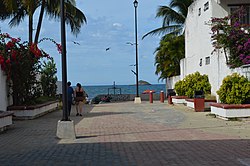
Bahía de Banderas is a bay on the Pacific Coast of Mexico, within the Mexican states of Jalisco and Nayarit. It is also the name of an administrative municipality, located on the bay in Nayarit state. The port and resort city of Puerto Vallarta is on the bay.
Chiquilistlán is a small town in the Mexican state of Jalisco. It is located in the Sierra Tapalpa mountains, at the foot of a hill called Chiquilichi, some 75 kilometres to the south-west of state capital Guadalajara.
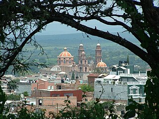
Amatitán is the seat of a municipality in the Mexican state of Jalisco, and is home to one of the world's largest tequila distilleries.
Xalisco is a city and its surrounding municipality of the same name in the Mexican state of Nayarit. The city had a population of 21,899 in the 2005 census while the municipality has an area of 290.6 km² and a population of 42,893. The municipality lies adjacent to the south side of Tepic, the state capital, and is part of the Tepic metropolitan area.
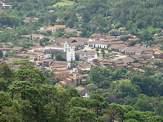
San Sebastián del Oeste is a town and municipality, located on the western part of Jalisco state, Mexico, between 20°39’45’’ - 21°02’30’’ N and 104°35’00’’ - 104°51’00’’ W, at a height of 1,480 metres (4,856 ft).
Pihuamo is a town and municipality located in the state of Jalisco in Mexico.
Matamoros is a municipality located in the Mexican state of Tamaulipas. Its municipal seat is the City of Matamoros.
Teocaltiche is a town and municipality in the central-western Mexican state of Jalisco. It is located in the northeastern highlands region of Jalisco, commonly referred to in Spanish as "Los Altos de Jalisco". The grasshopper or "chapulin" is a popular icon for the town.
Pantelhó is a town and municipality in the Mexican state of Chiapas in southern Mexico..
Zapotiltic is a town and municipality in the south region of the state of Jalisco, Mexico. It is located approximately 115 km south of Guadalajara. According to the "Conteo de Poblacion y Vivienda of 2015" the municipality had a population of 29,190.
Juanacatlán is a town and municipio (municipality) in the central region of the Mexican state of Jalisco.
Acatic is a town and municipality, in Jalisco in central-western Mexico. The municipality covers an area of 339.2 km². The town produces mainly Spanish style shingles, brick, adobe floor tile, chia, corn, and tequila. Pueblo Viejo Tequila is bottled near by. The town is the entry "gate" to Los Altos of Jalisco.
Acatlán de Juárez is a town and municipality, in Jalisco in central-western Mexico. The municipality covers an area of 154 km².
Concepción de Buenos Aires is a town and municipality, in Jalisco in central-western Mexico. The municipality covers an area of 265.6 km2.
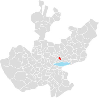
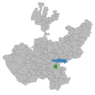
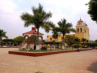
Ixtlahuacán de los Membrillos is a town and municipality, in Jalisco in central-western Mexico. The municipality covers an area of 184.25 km². It is located north of the Chapala municipality.
San Marcos is a town and municipality, in Jalisco in central-western Mexico. The municipality covers an area of 305.5 km2.
Villa Purificación is a town and municipality, in Jalisco in central-western Mexico. The municipality covers an area of 1,848 km².
San Martín de Hidalgo Municipality is a municipality located in the Región Valles of the state of Jalisco, Mexico. As of 2010, the population was 26,306. The municipal seat is San Martín de Hidalgo. Other administrative communities include 5 delegations and 18 agencies.
San Luis Río Colorado is a municipality in the Mexican state of Sonora in northwestern Mexico, covering an area of 8412.75 km2.