External links
Coordinates: 21°52′00″N105°27′00″W / 21.8666666767°N 105.45000001°W

| Authority control |
|
|---|
| | This article about a location in the Mexican state of Nayarit is a stub. You can help Wikipedia by expanding it. |
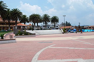
Tuxpan, is both a municipality and a municipal seat in the Mexican state of Nayarit. It is located in the west of the state and has boundaries with the municipalities of Rosamorada in the north, Santiago Ixcuintla in the south and west, and Ruiz in the east.
The area of the municipality is 474.3 km² and the population was 28,550 in 2005, which was a drop from the population of 34,079 in 1980. The population of the municipal seat was 22,481 in the same year.
Most of the land is flat and there is intensive agriculture. The main crops are beans, sorghum, tobacco, bananas, and mangoes. The estuary zone in the west is used for production of shrimp.
The municipality is crossed by the Río San Pedro and there is often extensive flooding in the rainy season.
Tuxpan during prehispanic times was an important place named Ayutuxpan, contributed to the kingdom of Sentispac. At Coamiles were settled the most important ceremonial centres; according to historic Christian Duverger, the ceremonial centre is composed by various structures, today are known 40, they possess more than 150 printings and its infrastructures are stones filled up with sun-dried bricks. It also embraces megalithic composes of big carving blocks, organized horizontally and vertically combined with voluminous rocks.
Leaders; Antonio R. Laureles and Prisciliano Góngora, they fought for the land divisions and formations of cooperatives in Tuxpan and the State of Nayarit.
They were murdered in 1922, at the back stalls inside the Government Palace, today known as Casa Fenelón
1530.- Military explorations of conquistador Nuño Beltrán de Guzmán crossed by the zone towards Aztlán. 1607.- Convent of Santa Catalina was built to evangelize natives. 1885.- After Independence Tuxpan become land of Tepic. 1917.- Constituted as a municipality of the Sovereign and Free State of Nayarit. 1919.- Farmers requested cooperative to subdivide farm lands. Also, the biggest cooperative in Mexico.
Coordinates: 21°52′00″N105°27′00″W / 21.8666666767°N 105.45000001°W
| Authority control |
|
|---|
| | This article about a location in the Mexican state of Nayarit is a stub. You can help Wikipedia by expanding it. |

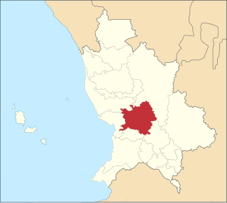
Nayarit, officially the Free and Sovereign State of Nayarit, is one of the 32 states that comprise the Federal Entities of Mexico. It is divided in 20 municipalities and its capital city is Tepic.
Nayarit is a state in West Mexico, divided into twenty municipalities. According to the 2020 Mexican Census, it is the fourth least populated state with 1,235,456 inhabitants and the 23rd largest by land area spanning 27,856.5 square kilometres (10,755.5 sq mi).

Bahía de Banderas is a bay on the Pacific Coast of Mexico, within the Mexican states of Jalisco and Nayarit. It is also the name of an administrative municipality, located on the bay in Nayarit state. The port and resort city of Puerto Vallarta is on the bay.

Bolaños Municipality is located in the north of the Mexican state of Jalisco.
Amatlán de Cañas is a municipality and municipal seat in the southwest of the Mexican state of Nayarit. The population in 2005 was 10,392 in a total area of 765 km², which made up 2.77% of the surface of the state. The municipal seat had a population of 3,275 in 2005.
El Nayar is a municipality in the Mexican state of Nayarit. The population was 30,551 in 2005 in a total area of 5,100 km². The municipal seat of Jesús María had a population of 1,520 in 2005. El Nayar is the home of the Huichol, Cora, and the Tepehuán Indians have adapted El Nayar.

Acaponeta is both a municipality and a town in the northern part of the Mexican state of Nayarit. The town is located at the geographical coordinates of 22°29′47″N105°21′34″W. The population of the municipality was 34,665 in the 2005 census, living in a total area of 1,667.7 km². The population of the municipal seat was 18,066, the fifth-largest community in the state. The Acaponeta River flows through the town. See maps at and
Tecuala is both a municipality and a town in the Mexican state of Nayarit, on the Pacific coast. The population of the municipality was 42,237 in a total area of 1,137 km² (2000) while the population of the town and municipal seat was 14,584 (2000). One of the longest beaches in the world, Playa Novillero, is located here.
La Yesca is a municipality and the municipal seat of the same in the Mexican state of Nayarit. The population of the municipality was 12,025 (2005). The population of the town and municipal seat was 356 inhabitants in 2005. The population density was 7 inhabitants per square kilometer, one of the lowest in the state.
Huajicori is both a municipality and the municipal seat of the same in the Mexican state of Nayarit. The population of the municipality was 10,294 in 2000 in a total area of 2,603.5 km². Its area makes up almost 10% of the state. The population of the town was 2,201 (2005).
San Pedro Lagunillas is both a municipality and the municipal seat of the same in the Mexican state of Nayarit. The population of the municipality was 7,155 (2005) in a total area of 520 square kilometers. The population of the town and municipal seat was 3,630 (2005). The population has been declining since 1980 when it was 8,308 inhabitants.
Xalisco is a city and its surrounding municipality of the same name in the Mexican state of Nayarit. The city had a population of 21,899 in the 2005 census while the municipality has an area of 290.6 km² and a population of 42,893. The municipality lies adjacent to the south side of Tepic, the state capital, and is part of the Tepic metropolitan area.
Rosamorada is a municipality of the state of Nayarit in Mexico. It is located in the extreme north of the state. The area of the municipality is 2,073 km² and the population was 32, 217 in 2005, showing a significant decrease from 1980 when it was 34,695. Most of the population is still rural with the major settlements being Rosamorada with 3,393 inhabitants; San Vicente with 4,556; Los Pericos with 2,441; Chilapa with 2,277; Pimientillo with 1,824 and El Tamarindo with 1,544.
Ruiz is a municipality and the municipal seat of the same located in the north of the Mexican state of Nayarit.

Ixtlán del Río is both a municipality and municipal seat in the Mexican state of Nayarit. In 2018 the population of the municipality was 33,289 and the total area was 581.4 km².

Santiago de Ixcuintla is a municipality and a municipal seat in the western Mexican state of Nayarit. The municipal population was 84,314 inhabitants with the municipal seat having 18,269. The area of the municipality was 1,831.92 square kilometers. It is located at 21º48'40" N and 105º12'23" W.

Ahuacatlán is both a municipality and a municipal seat in the Mexican state of Nayarit. It is located in the southeastern part of the state and has boundaries with the following municipalities: in the north with San Pedro Lagunillas, Santa María del Oro and Jala; in the south with the state of Jalisco and the municipality of Amatlán de Cañas; in the east with Ixtlán del Río, Jala and Amatlán de Cañas; and in the west with San Pedro Lagunillas.

Santa María del Oro is a municipality and municipal seat in the Mexican state of Nayarit. It is located in the south of the state and has boundaries with the municipalities of El Nayar, Tepic, Ahuacatlán, Jala, San Pedro Lagunillas, La Yesca, and Xalisco. The population was 21,688 in 2005, with the municipal seat of the same name having 3,314 inhabitants. The total area was 912.90 km².
Temoaya is a town and municipality in Mexico State, Mexico. It is located 18 kilometres (11 mi) from Toluca and 85 kilometres (53 mi) from Mexico City. It is known for its large ethnic Otomi population, the Centro Ceremonial Otomí and its tradition of making Persian style rugs using Mexican designs.
The Municipality of Tepic is one of the 20 municipalities dividing the Mexican state of Nayarit; its head city, the city of Tepic, is also the capital of the state.