The South Bay is a region of the Los Angeles metropolitan area, located in the southwest corner of Los Angeles County. The name stems from its geographic location stretching along the southern shore of Santa Monica Bay. The South Bay contains fifteen cities plus portions of the City of Los Angeles and unincorporated portions of the county. The area is bounded by the Pacific Ocean on the south and west and generally by the City of Los Angeles on the north and east.

The Pacific Electric Railway Company, nicknamed the Red Cars, was a privately owned mass transit system in Southern California consisting of electrically powered streetcars, interurban cars, and buses and was the largest electric railway system in the world in the 1920s. Organized around the city centers of Los Angeles and San Bernardino, it connected cities in Los Angeles County, Orange County, San Bernardino County and Riverside County.
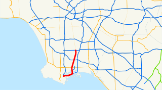
State Route 47 is a state highway in the U.S. state of California, connecting Terminal Island to the mainland in the Los Angeles area. From its south end at I-110 in San Pedro, it heads east across the Vincent Thomas Bridge to the island and the end of state maintenance. The state highway begins again at the junction with I-710 on Terminal Island, crossing the Schuyler Heim Bridge north to the mainland and the second terminus, where SR 103 begins. Signage continues along a locally maintained route, mainly Alameda Street, to the Gardena Freeway in Compton, and an unconstructed alignment follows the same corridor to the Santa Monica Freeway (I-10) near downtown Los Angeles.
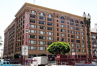
The historic Pacific Electric Building opened in 1905 as the terminal for the Pacific Electric Red Car Lines running east and south of downtown Los Angeles, as well as the company's main headquarters building. It was designed by architect Thornton Fitzhugh. Though not the first modern building in Los Angeles, nor the tallest, its large footprint and ten-floor height made it the largest building in floor area west of Chicago for several decades. Above the main floor terminal were five floors of offices and on the top three floors, the Jonathan Club, one of the city's leading businessmen's clubs. The club moved to its own building on Figueroa Street in 1925. After the absorption of the Pacific Electric into the Southern Pacific Railroad in 1911, the PE Building became the primary Los Angeles offices for the Southern Pacific.

103rd Street/Watts Towers is an at grade light rail station on the A Line of the Los Angeles Metro Rail.

Slauson is an elevated light rail station on the A Line of the Los Angeles Metro Rail. It consists of one island platform on the elevated A Line right-of-way over Slauson Avenue in the unincorporated community of Florence.
Vernon is an at-grade light rail station on the A Line of the Los Angeles Metro Rail.

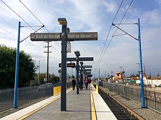
San Pedro Street is an at-grade light rail station on the A Line of the Los Angeles Metro Rail.
Rancho San Pedro was one of the first California land grants and the first to win a patent from the United States. The Spanish Crown granted the 75,000 acres (300 km2) of land to soldier Juan José Domínguez in 1784, with his descendants validating their legal claim with the Mexican government at 48,000 acres (190 km2) in 1828, and later maintaining their legal claim through a United States patent validating 43,119 acres (174.50 km2) in 1858. The original Spanish land grant included what today consists of the Pacific coast cities of Los Angeles harbor, San Pedro, the Palos Verdes peninsula, Torrance, Redondo Beach, Hermosa Beach, and Manhattan Beach, and east to the Los Angeles River, including the cities of Lomita, Gardena, Harbor City, Wilmington, Carson, Compton, and western portions of Long Beach and Paramount.

San Pedro Street is a major north-south thoroughfare in Los Angeles, California, running from Little Tokyo in Downtown Los Angeles to West Rancho Dominguez. San Pedro Street was one of the earliest roadways, along with Alameda Street, between central Los Angeles and the Port of Los Angeles; much of the road's original alignment south of Jefferson Boulevard has been renamed Avalon Boulevard.

The Los Angeles and Independence Railroad, opened on October 17, 1875, was a steam-powered rail line which ran between the Santa Monica Long Wharf and 5th and San Pedro streets in downtown Los Angeles.

The Port of Los Angeles Waterfront Red Car Line is a currently non-operational 2.5-kilometre (1.6 mi) heritage streetcar line for public transit along the waterfront in San Pedro, at the Port of Los Angeles in Los Angeles, California. It opened for service in July 2003, with a construction cost of $10 million. Service ended on 27 September 2015 due to major construction projects that would result in the demolition of a portion of the route. In March 2016 development plans for the port were announced which would include resumption of service on the Waterfront Red Car Line.

The Dominguez Rancho Adobe is California Historical Landmark Number 152, and in 1976 was placed on the National Register of Historic Places by the United States Department of the Interior.
The Santa Monica Air Line was an interurban air-line railroad operated by the Pacific Electric between Santa Monica and downtown Los Angeles which ran from 1909 to 1953 and has been reactivated as the Expo Line.
San Pedro via Gardena was a line of the Pacific Electric Railway. This was the original route to San Pedro, built by the Los Angeles Interurban Railway in 1903 and Pacific Electric assumed control in 1911.
The Long Beach Line was a major interurban railway operated by the Pacific Electric Railway between Los Angeles and Long Beach, California via Florence, Watts, and Compton. Service began in 1902 and lasted until 1961, the last line of the system to be replaced by buses. However, the Southern Pacific Transportation Company continued to operate freight on the tracks, as the Union Pacific Railroad still does north of Dominguez Junction, and in 1990 the Southern California Rapid Transit District opened the Blue Line light rail along the same right-of-way.

SS Columbia (1880–1907) was a cargo and passenger steamship that was owned by the Oregon Railway and Navigation Company and later the San Francisco and Portland Steamship Company. Columbia was constructed in 1880 by the John Roach & Sons shipyard in Chester, Pennsylvania for the Oregon Railway and Navigation Company.
J was a line operated by the Los Angeles Railway from 1911 to 1945, by Los Angeles Transit Lines from 1945 to 1958, and by the Los Angeles Metropolitan Transit Authority from 1958 to 1963

The Long Wharf in Santa Monica, also known as Port Los Angeles or the Mile Long Pier, was an extensive pier wharf constructed by the Southern Pacific Railroad Company in Santa Monica Bay from 1892–94. When it opened in 1894, it was the longest wharf in the world, measuring approximately 4,700 feet. It served as a cargo and passenger port until 1913, and in 1919 removal of the wharf started. The wharf, the 1000 foot tip of the pier, was removed by 1920. The remaining 3,600 feet of pier was used as a run down fishing pier until 1933, when the remainder of the pier was removed. One of the major imports to the wharf was lumber from Northern ports, to help in the construction boom in Southern California. Southern Pacific Railroad and the street cars of the Los Angeles Pacific Railroad served the wharf. Los Angeles Pacific Railroad ran passenger trams to the wharf and from midnight to sunrise ran cargo cars.