
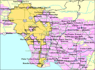
Covina is a city in Los Angeles County, California, about 22 miles (35 km) east of downtown Los Angeles, in the San Gabriel Valley. The population was 47,796 at the 2010 census, up from 46,837 at the 2000 census. The city's slogan, "One Mile Square and All There", was coined when the incorporated area of the city was only one square mile.

San Dimas is a city in the San Gabriel Valley of Los Angeles County, California, United States. As of the 2010 census, the city had a total population of 33,371. The city historically took its name from San Dimas Canyon in the San Gabriel Mountains above the northern section of present-day San Dimas. San Dimas derives its name from the Spanish name for Saint Dismas.

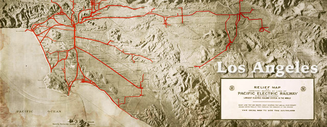
The Pacific Electric Railway Company, nicknamed the Red Cars, was a privately owned mass transit system in Southern California consisting of electrically powered streetcars, interurban cars, and buses and was the largest electric railway system in the world in the 1920s. Organized around the city centers of Los Angeles and San Bernardino, it connected cities in Los Angeles County, Orange County, San Bernardino County and Riverside County.
The Los Angeles metropolitan area, also known as Metropolitan Los Angeles, Metro LA or the Southland, is the 18th largest metropolitan area in the world and the second-largest metropolitan area in the United States. It is the 3rd largest city by nominal GDP in the world with a $1 trillion+ economy. It is entirely in the southern portion of the U.S. state of California.
The San Gabriel Valley is one of the principal valleys of Southern California, lying generally to the east of the city of Los Angeles. Surrounding features include:
The Arroyo Seco Parkway, also known as the Pasadena Freeway, is the first freeway that was built in the United States. It connects Los Angeles with Pasadena alongside the Arroyo Seco seasonal river. It is notable not only for being the first, mostly opened in 1940, but for representing the transitional phase between early parkways and modern freeways. It conformed to modern standards when it was built, but is now regarded as a narrow, outdated roadway. A 1953 extension brought the south end to the Four Level Interchange in downtown Los Angeles and a connection with the rest of the freeway system.
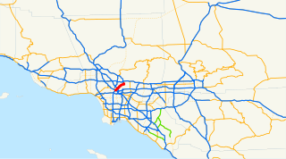
Route 710, consisting of the non-contiguous segments of State Route 710 and Interstate 710 (I-710), is a major north–south state highway and auxiliary Interstate Highway in the Los Angeles metropolitan area of the U.S. state of California. Also called the Los Angeles River Freeway prior to November 18, 1954, the highway was initially planned to connect Long Beach and Pasadena, but a gap in the route exists from Alhambra to Pasadena through South Pasadena due to community opposition to its construction.

Moses Hazeltine Sherman was an American land developer who built the Phoenix Street Railway in Phoenix, Arizona and streetcar systems that would become the core of the Los Angeles Railway and part of the Pacific Electric Railway in Los Angeles, California, and owned and developed property in areas such as West Los Angeles, the San Fernando Valley and Hollywood, California. He also served on the Los Angeles Water Board. He was also known as M. H. Sherman and General M. H. Sherman.

The Southern California freeways are a vast network of interconnected freeways in the megaregion of Southern California, serving a population of 23 million people. The Master Plan of Metropolitan Los Angeles Freeways was adopted by the Regional Planning Commission in 1947 and construction began in the early 1950s. The plan hit opposition and funding limitations in the 1970s, and by 2004, only some 61% of the original planned network had been completed.

Sunset Junction is an informal name for a portion of the Silver Lake district of Los Angeles, California. It was home to the Sunset Junction Street Fair from 1980 through 2010. It is located in the southwestern part of the district along Sunset Boulevard.
The Santa Monica Air Line was an interurban air-line railroad operated by the Pacific Electric between Santa Monica and downtown Los Angeles which ran from 1909 to 1953 and has been reactivated as the Expo Line.
Upland-San Bernardino was an interurban line operated by the Pacific Electric Railway between Downtown Los Angeles and San Bernardino, California. This line also had shorter service that terminated before the end of the line at Baldwin Park, Covina, and San Dimas. Though service along this line in its entirety was discontinued in November 1941, it still stands as the fourth-longest rapid transit line in American history, after the Sacramento Northern's Chico and Colusa services, and the Pacific Electric's own Rialto-Riverside line.

Culver City is an elevated light rail station in the Los Angeles Metro Rail system in Culver City, California. It is located at the northeast edge of downtown Culver City. A rail station since the 1800s, it is now served by the E Line. It was the E line's terminus from June 2012 to May 2016 until Phase 2 further extended the terminus to Downtown Santa Monica station.
Beverly Hills was a suburban line of the Pacific Electric Railway. It was opened in 1909 by the Pasadena and Pacific Railroad and taken over by the Pacific Electric in 1911. The route terminus switched over to the Subway Terminal Building in 1926.
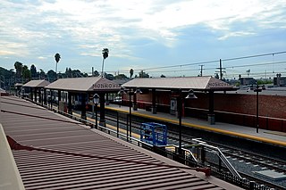
Monrovia is an at grade light rail station in the Los Angeles County Metro Rail system located near the intersection of Duarte Road and Myrtle Avenue in Monrovia, California. This station is served by the Metro Gold Line.
The Sierra Vista Line was a route of the Pacific Electric Railway from 1895 to 1950, first in the Northern District and later the Southern District.
The California Central Railway was incorporated on April 23, 1887, with headquarters in San Bernardino, California. George O. Manchester was the President of the corporation.

Los Angeles Pacific Railroad (1899−1906) (LAP) was an electric railway and steam locomotive public transit and cargo shipping railway system in Los Angeles County, California. At its peak it had 180-miles of track from Pasadena, through Downtown Los Angeles, the Westside, and Santa Monica, then to the South Bay towns along Santa Monica Bay.
Harris & Frank was a Los Angeles-based clothing retailer founded by Leopold Harris in Los Angeles in 1856, only eight years after the city had passed from Mexican to American control.
