
Alpine County is a county in eastern California located within the Sierra Nevada on the state border with Nevada. As of the 2010 Census, the population was 1,175, which declined to 1,129 in 2019, making it California's least populous county. The county seat and largest community is Markleeville.
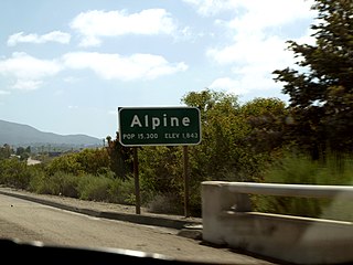
Alpine is a census-designated place (CDP) in the Cuyamaca Mountains of San Diego County, California. Alpine had a population of 14,236 at the 2010 census, up from 13,143 at the 2000 census. The town is largely surrounded by the Cleveland National Forest and borders two reservations of the Kumeyaay Nation, Viejas and Sycuan, and the rural unincorporated areas around the city of El Cajon.

Portola Valley is an incorporated town in San Mateo County, California, United States, which was founded in 1964. It is the wealthiest town in America per the American Community Survey, by the U.S. Census Bureau based on per-capita income for communities larger than 4,000. Home prices are also among the highest in the nation.

Alpine is a city in and the county seat of Brewster County, Texas, United States. The population was 5,905 at the 2010 census. The town has an elevation of 4,475 ft, and the surrounding mountain peaks are over a mile (1600 m) above sea level. The university, hospital, library, and retail make Alpine the center of the sprawling 12,000 square miles (31,000 km2) but wide open Big Bend area including Brewster, Presidio, and Jeff Davis Counties.

Alpine is a city on the northeastern edge of Utah County, Utah, United States. The population was 9,555 at the 2010 census. Alpine has been one of the many quickly-growing cities of Utah since the 1970s, and especially the 1990s. It is located on the slopes of the Wasatch Range north of Highland and American Fork. The west side of the city runs above the Wasatch Fault.
Woodfords is an unincorporated community in Alpine County, California, near Markleeville. For census purposes, it is included in Alpine Village. It is located 6 miles (9.7 km) north-northwest of Markleeville, at 38°46′40″N119°49′19″W.

Jennie Lakes Wilderness is a protected area in the Sierra Nevada, in Tulare County, California. It is located 60 miles (97 km) east of Fresno and managed by the US Forest Service.
Alpine Creek is a small river in San Mateo County, California. It flows about 5 miles (8 km), from its source near West Alpine Road about a mile southwest of Skyline Boulevard (CA 35), to its confluence with La Honda Creek to form San Gregorio Creek in La Honda at California State Route 84.

Centerville is a former settlement in Alpine County, California, United States.
Silver Mountain is a former settlement in Alpine County, California. It was located on Silver Creek 5 miles (8 km) north-northeast of Ebbetts Pass, at an elevation of 6411 feet.
Losee is a former settlement in Butte County, California, United States. It was located about half a mile (1 km) south of Haselbusch. Losee was on the Sacramento Northern Railroad line.
Apyu is a former Karok settlement in Humboldt County, California. It was located about 1 mile (1.6 km) above the Salmon River mouth near the upper rapids above the mouth of the Salmon across from Ishipishi. Its precise location is unknown. It was approximately 0.5 miles (0.80 km) east of Somes Bar, a community in Siskiyou County.
Shregegon is a former Yurok settlement in Humboldt County, California. It was located about 1 mile (1.6 km) above the mouth of Pecwan Creek, at an elevation of 125 feet.
Coalinga Mineral Springs is a former settlement in Fresno County, California. It was located 11 miles (18 km) west of Coalinga.

Iaqua is a former settlement in Humboldt County, California. It was located 5.5 miles (8.9 km) south of Kneeland.
Narka is a former settlement in Inyo County, California. It was located on the Southern Pacific Railroad about 3.5 miles (5.6 km) south of the current settlement of Little Lake. Narka began as a railroad camp before Little Lake was settled. A post office operated at Narka from 1909 to 1913, when the service was transferred to Little Lake.

Desert Spring is a former settlement in Kern County, California in the Fremont Valley, south of Red Rock Canyon State Park. It was located 1.5 miles (2.4 km) northeast of Cantil. About .8 miles norht of California State Route 58 on Bellville Road at the railroad tracks.
Tukutnut is a former Rumsen settlement in Monterey County, California.
La Libertad, California is a former settlement in Fresno County, California that was 1/2 mile south and 5 miles east of Burrel, California. It was an early Mexican settlement in San Joaquin Valley, on the eastern route of El Camino Viejo that existed there at least until 1870.

