
Los Angeles County, officially the County of Los Angeles, is the most populous county in the United States and in the U.S. state of California, with more than ten million inhabitants as of 2018. It is the largest non–state-level government entity in the United States. Its population is greater than that of 41 individual U.S. states. It has the third-largest metropolitan economy in the world, with a Nominal GDP of more than $700 billion. It has 88 incorporated cities and many unincorporated areas and, at 4,083 square miles (10,570 km2), it is larger than the combined areas of Delaware and Rhode Island. The county is home to more than one-quarter of California residents and is one of the most ethnically diverse counties in the United States. Its county seat, Los Angeles, is also California's most populous city and the second most populous city in the United States, with about four million residents.
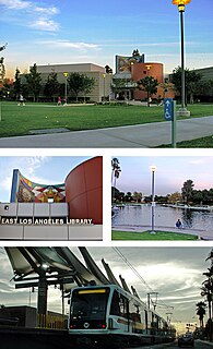
East Los Angeles, or East L.A., known in the 1920s as Belvedere or Belvedere Gardens, is an unincorporated area and census-designated place (CDP) in Los Angeles County, California. As of the 2010 census it had a population of 126,496. It is 96% Latino—the highest percentage of any neighborhood in Los Angeles County, and the highest of any CDP in the United States with a population of 100,000 or more.

South Whittier is an unincorporated community and census-designated place in Los Angeles County, California just south of the city of Whittier. As of the 2010 census, the CDP had a total population of 57,156, up from 55,193 at the 2000 census.

West Whittier-Los Nietos is a census-designated place (CDP) in Los Angeles County, California, near the San Gabriel River and the San Gabriel River (I-605) Freeway. The population was 25,540 at the 2010 census, up from 25,129 at the 2000 census. The census area consists of separate unincorporated communities of Los Nietos and West Whittier.

Whittier is a city in Southern California in Los Angeles County, part of the Gateway Cities. The 14.7-square-mile (38.0 km2) city had 85,331 residents as of the 2010 United States Census, an increase of 1,631 from the 2000 Census figure. Whittier was incorporated in February 1898 and became a charter city in 1955. The city is named for the Quaker poet John Greenleaf Whittier and is home to Whittier College.
The San Gabriel Valley is one of the principal valleys of Southern California, lying generally to the east of the city of Los Angeles. Surrounding features include:
The Southern California News Group (SCNG), formerly the San Gabriel Valley News Group and the Los Angeles News Group, is an umbrella group of local daily newspapers published in the greater Los Angeles area by Digital First Media.

The Rio Hondo is a tributary of the Los Angeles River in Los Angeles County, California, approximately 16.4 miles (26.4 km) long. As a named river, it begins in Irwindale and flows southwest to its confluence in South Gate, passing through several cities. Above Irwindale its main stem is known as Santa Anita Creek, which extends another 10 miles (16 km) northwards into the San Gabriel Mountains where the source, or headwaters, of the river are found.
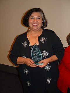
Jesus Gloria Molina is an American politician and a former member of the Los Angeles County Board of Supervisors and the Los Angeles County Metropolitan Transportation Authority. Molina broke into politics in 1982 by going against the powerful male-dominated Eastside political machine for a seat on the California State Assembly. She became the very first Latina elected to the California Assembly. She had a long unbeaten streak in electoral politics. In 1987, she was the first Latina elected to the Los Angeles City Council and to the Los Angeles County Board of Supervisors in 1991. She was on the board for 23 years.

The San Gabriel River is a mostly urban waterway flowing 58 miles (93 km) southward through Los Angeles and Orange Counties, California in the United States. It is the central of three major rivers draining the Greater Los Angeles Area, the others being the Los Angeles River and Santa Ana River. The river's watershed stretches from the rugged San Gabriel Mountains to the heavily developed San Gabriel Valley and a significant part of the Los Angeles coastal plain, emptying into the Pacific Ocean between the cities of Long Beach and Seal Beach.

State Route 72 is a state highway in the U.S. state of California. The route runs along Whittier Boulevard in the Los Angeles area from SR 39 in La Habra to Interstate 605 in Whittier. SR 72 forms part of El Camino Real.

State Route 39 is a state highway in the U.S. state of California that travels through Orange and Los Angeles counties. Its southern terminus is at Pacific Coast Highway, in Huntington Beach. SR 39's northern terminus is at Islip Saddle on Angeles Crest Highway in the Angeles National Forest, but its northernmost 4.5-mile (7.2 km) segment has been closed to the public since 1978 due to a massive mud and rockslide. It would cost a total of $100 million USD to repair the road.

The Puente Hills are a chain of hills, one of the lower Transverse Ranges, in an unincorporated area in eastern Los Angeles County, California, in the United States. The western end of the range is often referred to locally as the Whittier Hills.

Area code 562 is a California telephone area code that was split from area code 310 on January 25, 1997. It is the area code for much of southeastern Los Angeles County, including Long Beach, and parts of northern Orange County.

The 1987 Whittier Narrows earthquake occurred in the southern San Gabriel Valley and surrounding communities of southern California, United States, at on October 1. The moderate 5.9 magnitude blind thrust earthquake was centered several miles north of Whittier in the town of Rosemead, had a relatively shallow depth, and was felt throughout southern California and southern Nevada. Many homes and businesses were affected, along with roadway disruptions, mainly in Los Angeles and Orange counties. Damage estimates ranged from $213–358 million, with 200 injuries, three directly-related deaths, and five additional fatalities that were associated with the event.

The Whittier Narrows is a narrows or water gap in California, United States, between the Puente Hills to the east and the Montebello Hills to the west. The gap is located at the southern boundary of the San Gabriel Valley, through which the Rio Hondo and the San Gabriel River flow through to enter the Los Angeles Basin. The gap is also traversed by both Interstate 605 and California State Route 19.

Evergreen Memorial Park & Crematory is a cemetery in the East Side neighborhood of Boyle Heights, Los Angeles, California.

California's 38th congressional district is a congressional district in the U.S. state of California based in suburban eastern Los Angeles County and Orange County California. The district is currently represented by Democrat Linda Sánchez.
The Whittier Daily News is a paid local daily newspaper for Whittier, California. Coverage area includes Whittier, South Whittier, Pico Rivera, La Habra Heights, Santa Fe Springs and La Mirada. The Whittier Daily News is a member of Southern California News Group, a division of Digital First Media. It is also part of the San Gabriel Valley Newspaper Group, along with the San Gabriel Valley Tribune and the Pasadena Star-News.

Bartolo is a former settlement in Los Angeles County, California. It lay at an elevation of 223 feet. Bartolo still appeared on maps as of 1926. Its original name came from Rancho Paso de Bartolo, the lands of the Mexican governor of California, Pio Pico, which in turn was named for the San Gabriel River ford called Paso de Bartolo Viejo, near Beverly Road and the San Gabriel River. It was a station on the Union Pacific Railroad at the junction of its branch line to Whittier and its main line. Today, the area is part of the cities of Whittier and Pico Rivera, which is named for Pio Pico.

