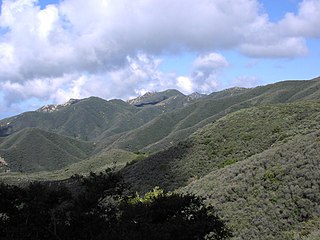
Chaparral is a shrubland or heathland plant community found primarily in the US state of California and in the northern portion of the Baja California Peninsula, Mexico. It is shaped by a Mediterranean climate and wildfire, featuring summer-drought-tolerant plants with hard sclerophyllous evergreen leaves, as contrasted with the associated soft-leaved, drought-deciduous, scrub community of coastal sage scrub, found below the chaparral biome. Chaparral covers 5% of the state of California and associated Mediterranean shrubland an additional 3.5%. The name comes from the Spanish word chaparro, for evergreen oak shrubland.

The Baja California Peninsula is a peninsula in Northwestern Mexico. It separates the Pacific Ocean from the Gulf of California. The peninsula extends 1,247 km from Mexicali, Baja California in the north to Cabo San Lucas, Baja California Sur in the south. It ranges from 40 km at its narrowest to 320 km at its widest point and has approximately 3,000 km of coastline and approximately 65 islands. The total area of the Baja California Peninsula is 143,390 km2 (55,360 sq mi), roughly the same area as the country of Nepal.

Palm Desert is a city in Riverside County, California, United States, in the Coachella Valley, approximately 14 miles (23 km) east of Palm Springs, 121 miles (194 km) northeast of San Diego and 122 miles (196 km) east of Los Angeles. The population was 48,445 at the 2010 census, up from 41,155 at the 2000 census. The city was one of the state's fastest growing in the 1980s and 1990s, beginning with 11,801 residents in 1980, doubling to 23,650 in 1990, 35,000 in 1995, and nearly double its 1990 population by 2000. A major center of growth in the Coachella Valley, Palm Desert is a popular retreat for "snowbirds" from colder climates, who swell its population by an estimated 31,000 each winter. In the past couple of years Palm Desert has seen more residents become "full-timers", mainly from the coasts and urban centers of California, who have come for both affordable and high-valued home prices.

The Mojave Desert is an arid rain-shadow desert and the driest desert in North America. It is in the North American Southwest, primarily within southeastern California and southern Nevada, and it occupies 47,877 sq mi. Small areas also extend into Utah and Arizona. Its boundaries are generally noted by the presence of Joshua trees, which are native only to the Mojave Desert and are considered an indicator species, and it is believed to support an additional 1,750 to 2,000 species of plants. The central part of the desert is sparsely populated, while its peripheries support large communities such as Las Vegas, Barstow, Lancaster, Palmdale, Victorville, and St. George.
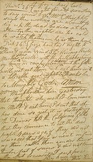
The Donner Party was a group of American pioneers who migrated to California in a wagon train from the Midwest. Delayed by a series of mishaps, they spent the winter of 1846–47 snowbound in the Sierra Nevada. Some of the migrants resorted to cannibalism to survive, eating the bodies of those who had succumbed to starvation and sickness.

The Sonoran Desert is a North American desert which covers large parts of the Southwestern United States in Arizona and California and of Northwestern Mexico in Sonora, Baja California, and Baja California Sur. It is the hottest desert in Mexico. It has an area of 260,000 square kilometers (100,000 sq mi). The western portion of the United States–Mexico border passes through the Sonoran Desert.

Arthur B. Ripley Desert Woodland State Park is a state park in the western Antelope Valley in Southern California. The park protects mature stands of Joshua trees and California juniper trees in their western Mojave Desert habitat.

The Transverse Ranges are a group of mountain ranges of southern California, in the Pacific Coast Ranges physiographic region in North America. The Transverse Ranges begin at the southern end of the California Coast Ranges and lie within Santa Barbara, Ventura, Los Angeles, San Bernardino, Riverside and Kern counties. The Peninsular Ranges lie to the south. The name Transverse Ranges is due to their east–west orientation, making them transverse to the general northwest–southeast orientation of most of California's coastal mountains.

California's Colorado Desert is a part of the larger Sonoran Desert. It encompasses approximately 7 million acres (28,000 km2), including the heavily irrigated Coachella and Imperial valleys. It is home to many unique flora and fauna.

In archaeology, rock art is human-made markings placed on natural stone; it is largely synonymous with parietal art. A global phenomenon, rock art is found in many culturally diverse regions of the world. It has been produced in many contexts throughout human history, although the majority of rock art that has been ethnographically recorded has been produced as a part of ritual. Such artworks are often divided into three forms: petroglyphs, which are carved into the rock surface, pictographs, which are painted onto the surface, and earth figures, formed on the ground. The oldest known rock art dates from the Upper Palaeolithic period, having been found in Europe, Australia, Asia and Africa. Archaeologists studying these artworks believe that they likely had magico-religious significance.

Chiriaco Summit is a small unincorporated community and travel stop located along Interstate 10 in the Colorado Desert of Southern California. It lies 19 miles (31 km) west of Desert Center on the divide between the Chuckwalla Valley and the Salton Sea basin at an elevation of 1,706 feet (520 m).

Aridoamerica denotes an ecological region spanning Mexico and the Southwest United States, defined by the presence of the culturally significant staple foodstuff Phaseolus acutifolius, a drought-resistant bean. Its dry, arid climate and geography stand in contrast to the verdant Mesoamerica of present-day central Mexico into Central America to the south and east, and the higher, milder "island" of Oasisamerica to the north. Aridoamerica overlaps with both.

Palm Springs is a desert resort city in Riverside County, California, United States, within the Coachella Valley. It is located approximately 55 mi (89 km) east of San Bernardino, 107 mi (172 km) east of Los Angeles, 123 mi (198 km) northeast of San Diego, and 268 mi (431 km) west of Phoenix, Arizona. The population was 44,552 as of the 2010 census. Palm Springs covers approximately 94 square miles (240 km2), making it the largest city in Riverside County by land area.

The Lower Colorado River Valley ("LCRV") is the river region of the lower Colorado River of the southwestern United States in North America that rises in the Rocky Mountains and has its outlet at the Colorado River Delta in the northern Gulf of California in northwestern Mexico, between the states of Baja California and Sonora. This north–south stretch of the Colorado River forms the border between the U.S. states of California/Arizona and Nevada/Arizona, and between the Mexican states of Baja California/Sonora.

The Riverside Mountains are a mountain range in Riverside County, California. The town of Vidal, California is located in the West Riverside Mountains.

The Cleghorn Lakes Wilderness is a 33,475-acre (135.47 km2) wilderness area in the southern Mojave Desert. It is located 16 miles (26 km) northeast of Twentynine Palms, California, and 20 miles (32 km) north of Joshua Tree National Park. It is managed by the Bureau of Land Management.
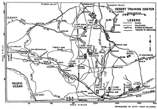
The Desert Training Center (DTC), also known as California–Arizona Maneuver Area (CAMA), was a World War II training facility established in the Mojave Desert and Sonoran Desert, largely in Southern California and Western Arizona in 1942.

Relief Hill is an unincorporated community in Nevada County, California. Relief Hill is located roughly midway between North Bloomfield and the town of Washington. It lies at an elevation of 3,947 feet. The post office established in 1894 was named Relief, and that name appears on some maps, especially those from around the turn of the nineteenth century. However, the town's inhabitants and most historians called it Relief Hill. The post office was discontinued in 1921.
Desert Sands is a 1955 American adventure film directed by Lesley Selander and written by Danny Arnold, George W. George and George F. Slavin. The film stars Ralph Meeker, Marla English, J. Carrol Naish, John Carradine, Ron Randell, John Smith and Keith Larsen. The film was released on November 18, 1955, by United Artists. The film was based on the 1954 novel Punitive Action, one of a series of French Foreign Legion novels written by John Robb. Unlike many Foreign Legion films the film was set in the 1950s.

The Philip L. Boyd Deep Canyon Desert Research Center is one of the original seven of the total 39 sites in the University of California Natural Reserve System. It contains lands originally donated to the University by regent Philip L. Boyd in 1958. The Research Center is contained within UNESCO's Mojave and Colorado Deserts Biosphere Reserve.

