The Los Angeles Community College District (LACCD) is the community college district serving Los Angeles, California, United States and some of its neighboring cities and certain unincorporated areas of Los Angeles County. Its headquarters are in Downtown Los Angeles. Over the past seventy-seven years LACCD has served as educator to more than three million students. In addition to typical college aged students, the LACCD also serves adults of all ages. Indeed, over half of all LACCD students are older than 25 years of age, and more than a quarter are 35 or older. LACCD educates almost three times as many Latino students and nearly four times as many African-American students as all of the University of California campuses combined. Eighty percent of LACCD students are from underserved populations. The Los Angeles Community College District is the largest community college district in the United States and is one of the largest in the world. The nine colleges within the district offer educational opportunities to students in Los Angeles. It serves students located in the Alhambra, Beverly Hills, Burbank, Culver City, Garvey, Las Virgenes, Los Angeles, Montebello, Palos Verdes and San Gabriel school districts. The district covers the Los Angeles city limits, San Fernando, Calabasas, Agoura Hills, Hidden Hills, Burbank, West Hollywood, Beverly Hills, Culver City, Alhambra, Monterey Park, San Gabriel, Rosemead, Montebello, Commerce, Vernon, Huntington Park, Bell, Cudahy, Bell Gardens, South Gate, Gardena, Carson, Lomita, Palos Verdes Estates, Rolling Hills, Rancho Palos Verdes, and numerous unincorporated communities, including East Los Angeles, Florence-Firestone, Athens, and Walnut Park. The LACCD consists of nine colleges and covers an area of more than 882 square miles (2,280 km2).

Southern California is a geographic and cultural region that generally comprises California's southernmost counties, and is the second most populous urban agglomeration in the United States. The region contains ten counties: Imperial, Los Angeles, Orange, Riverside, San Bernardino, San Diego, Santa Barbara, San Luis Obispo, Ventura, and Kern counties.

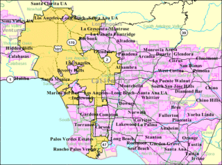
Greater Los Angeles is the second-largest urban region in the United States, encompassing five counties in southern California, extending from Ventura County in the west to San Bernardino County and Riverside County on the east, with Los Angeles County in the center and Orange County to the southeast. It consists of three metropolitan areas in Southern California: the Los Angeles metropolitan area, the Inland Empire, and the Ventura/Oxnard metropolitan area.

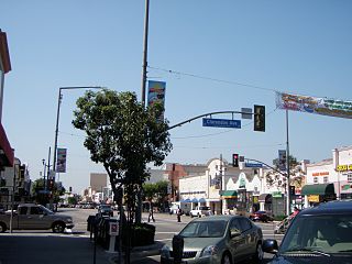
Florence-Graham is a census-designated place (CDP) in Los Angeles County, California. The population was 63,387 at the 2010 census, up from 60,197 at the 2000 census. The census area includes separate communities of Florence, Firestone Park, and Graham.
The Los Angeles metropolitan area, also known as Metropolitan Los Angeles or the Southland, is the 30th largest metropolitan area in the world and the second-largest metropolitan area in the United States. It is the 3rd largest city by GDP in the world with a $1 trillion+ economy. It is entirely in the southern portion of the U.S. state of California. The tallest building in the Los Angeles metropolitan area is the Wilshire Grand Center at 1,100 feet in Downtown Los Angeles.

National City Lines, Inc. (NCL) was a public transportation company. The company grew out of the Fitzgerald brothers' bus operations, founded in Minnesota, United States in 1920 as a modest local transport company operating two buses. Part of the Fitzgerald's operations were reorganized into a holding company in 1936, and later expanded about 1938 with equity funding from General Motors, Firestone Tire, Standard Oil of California and Phillips Petroleum for the express purpose of acquiring local transit systems throughout the United States in what became known as the General Motors streetcar conspiracy. The company formed a subsidiary, Pacific City Lines in 1937 to purchase streetcar systems in the western United States. National City Lines, and Pacific City Lines were indicted in 1947 on charges of conspiring to acquire control of a number of transit companies, and of forming a transportation monopoly for the purpose of "conspiring to monopolize sales of buses and supplies to companies owned by National City Lines." They were acquitted on the first charge and convicted on the second in 1949.

The Santa Monica Mountains is a coastal mountain range in Southern California, paralleling the Pacific Ocean. It is part of the Transverse Ranges. Because of its proximity to densely populated regions, it is one of the most visited natural areas in California. Santa Monica Mountains National Recreation Area is located in this mountain range.
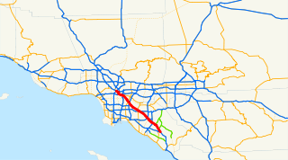
The Santa Ana Freeway is one of the principal freeways in Southern California, connecting Los Angeles and its southeastern suburbs including the freeway's namesake, the city of Santa Ana. The freeway begins at its junction with the San Diego Freeway, called the El Toro Y, in Irvine, signed as I-5. From there, it generally goes southeast to northwest to the East Los Angeles Interchange, where it takes the designation of U.S. Route 101 (US 101). It then proceeds 2.95 miles (4.75 km) northwest to the Four Level Interchange in downtown Los Angeles. Formerly, the entirety of the route was marked as US 101 until the 1964 highway renumbering, which truncated US 101 to the East Los Angeles Interchange and designated the rest of the freeway as I-5.
East Los Angeles College (ELAC) is a community college of the Los Angeles Community College District part of the California Community Colleges System in the Los Angeles suburb of Monterey Park. Fourteen communities comprise its primary service area. With an enrollment of 34,578 students, ELAC is the largest student body campus in the Los Angeles Community College District. It was located in northeastern East Los Angeles before that part of unincorporated East Los Angeles was annexed by Monterey Park in the early 1970s.
Firestone Tire and Rubber Company is an American tire company founded by Harvey Firestone in 1900 initially to supply solid rubber side-wire tires for fire apparatus, and later, pneumatic tires for wagons, buggies, and other forms of wheeled transportation common in the era. Firestone soon saw the huge potential for marketing tires for automobiles, and the company was a pioneer in the mass production of tires. Harvey Firestone had a personal friendship with Henry Ford, and used this to become the original equipment supplier of Ford Motor Company automobiles, and was also active in the replacement market.
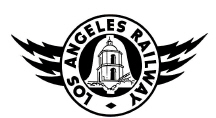
The Los Angeles Railway was a system of streetcars that operated in Central Los Angeles and surrounding neighborhoods between 1901 and 1963. It operated on 3 ft 6 in narrow gauge tracks. The company carried many more passengers than the Pacific Electric Railway's Red Cars, which served a larger area of Los Angeles.

State Route 42 is a decommissioned state highway in the southern region of the U.S. state of California, running along Manchester Avenue, Manchester Boulevard and Firestone Boulevard in Los Angeles and the cities south of it. After 1968, it ran from State Route 1 west of Inglewood east to Interstate 5 in Norwalk. Though signed as SR 42, it was officially Route 105 until it was replaced by the parallel Interstate 105 October 14, 1993. The entire route was deleted from the California Freeway and Expressway System in 2000, with the remaining portion of SR 42 being relinquished to local jurisdictions in that year, but the route is still occasionally signed off as SR 42.
Stonewood Center is a shopping mall located in Downey, California, which is one of the Gateway Cities of Southeastern Los Angeles County. It is located at the intersection of Firestone and Lakewood Boulevards, and it is from this intersection that the mall's name is derived. It is within a few miles of many freeways in the area: I-5 and I-605, I-710 and I-105 freeways. The mall is owned and operated by The Macerich Company and is part of its trifecta of malls in southeast Los Angeles County along with the Los Cerritos Center in Cerritos and the Lakewood Center in Lakewood. Stonewood Center comprises 145 stores, including several restaurants.

Founded in 1915, the Los Angeles Area Council (LAAC) (#033) served most of the City of Los Angeles as well as several other cities in the greater Los Angeles area. It was one of five Boy Scouts of America councils in Los Angeles County, California. Since its founding in 1915, the Los Angeles Area Council has brought its purpose and values to millions of youth. The Council served 54,567 youth in the Greater Los Angeles Area in 2008 alone.

South Los Angeles is a region in southern Los Angeles County, California, and mostly lies within the city limits of Los Angeles, just south of downtown.

The following outline is provided as an overview of and topical guide to the U.S. state of California.
Greater Los Angeles Area Council (GLAAC) is a new Boy Scouts of America Council created from the merger of the Los Angeles Area Council and the San Gabriel Valley Council. The vote to merge was held on March 21, 2015. The new name for the Council, Greater Los Angeles Area Council, was announced on June 11, 2015. The new Council will continue with Scouting Service centers in Los Angeles and Pasadena. GLAAC has three Scout shops located in Los Angeles, San Pedro and Pasadena. Also in Pasadena is a local service center. GLAAC operates seven camps in the greater Los Angeles area. Due to the large size of the two original councils, the merger was a process that was completed over a time span, the merger was completed in 2017.