V (Los Angeles Railway)

Last updated

V
Logo Los Angeles Metropolitan Transit Authority.svg
Overview
Owner Los Angeles Metropolitan Transit Authority
LocaleLos Angeles, Vernon
Termini
Stations50
Service
Type Streetcar
System Los Angeles Railway
Los Angeles Metropolitan Transit Authority
History
Opened1914
ClosedMarch 31, 1963 (1963-03-31)
Technical
Track gauge 3 ft 6 in (1,067 mm)
Electrification 600 V DC overhead line
Route map

Contents

1955–1963
BSicon uWSL+r.svg
Los Angeles City College
BSicon uHST.svg
Vermont and Melrose
BSicon uHST.svg
Vermont and Clinton
BSicon uSKRZ-G4o.svg
BSicon uHST.svg
Vermont and Rosewood
BSicon uHST.svg
Vermont and Beverly
BSicon uHST.svg
Vermont and 1st
BSicon uCONTgq-.svg
BSicon uHST.svg
BSicon ucSTRq-.svg
BSicon udSTR+r-.svg
Vermont and 3rd
  R    S  
BSicon uHST.svg
Vermont and 4th
BSicon uHST.svg
Vermont and 5th
BSicon uHST.svg
Vermont and 6th
BSicon uHST.svg
Vermont and Wilshire
BSicon uHST.svg
BSicon uABZgl+l.svg
BSicon uCONTfq.svg
Vermont and 7th
  R  
BSicon u-CONTgq.svg
BSicon uHST.svg
BSicon uc-STRq.svg
BSicon ud-STR+r.svg
Vermont and 8th
  S  
BSicon uHST.svg
Vermont and 9th
BSicon uHST.svg
Vermont and Olympic
BSicon uHST.svg
Vermont and 11th
BSicon uCONTgq.svg
BSicon uHST.svg
BSicon uKRZ.svg
BSicon uCONTfq.svg
Vermont and Pico
  P  
BSicon uHST.svg
Vermont and Venice
BSicon uHST.svg
Vermont and Washington
BSicon uHST.svg
Vermont and 24th
BSicon uHST.svg
Vermont and Adams
BSicon uHST.svg
Vermont and 29th
BSicon uCONTgq.svg
BSicon uHST.svg
BSicon uKRZ.svg
BSicon uCONTfq.svg
Vermont and Jefferson
  J  
BSicon uHST.svg
Vermont and 36th
BSicon uHST.svg
Vermont and 37th
BSicon CONTgq.svg
BSicon uHST.svg
BSicon STRq.svg
BSicon CONTfq.svg
Vermont and Exposition
PE Bolt.svg
BSicon uHST.svg
Vermont and 39th
BSicon uHST.svg
Vermont and Leighton
BSicon uCONTgq.svg
BSicon uHST.svg
BSicon uKRZ.svg
BSicon uCONTfq.svg
Vermont and Santa Barbara
  5  
BSicon uHST.svg
Vermont and 42nd
BSicon uCONTgq.svg
BSicon uHST.svg
BSicon uABZgr.svg
Vermont and Vernon
  K    U  
BSicon uHST.svg
Vernon and Hoover
BSicon uHST.svg
Vernon and Figueroa
BSicon uSKRZ-G4o.svg
BSicon uHST.svg
Vernon and Grand
BSicon uHST.svg
Vernon and Broadway
BSicon uHST.svg
Vernon and Main
BSicon uHST.svg
Vernon and Wall
BSicon uHST.svg
Vernon and San Pedro
BSicon uHST.svg
Vernon and Towne
BSicon uCONTgq.svg
BSicon uHST.svg
BSicon uKRZ+l.svg
BSicon uCONTfq.svg
Vermont and Avalon
  J    S  
BSicon uHST.svg
Vernon and McKinley
BSicon uHST.svg
Vernon and Central
BSicon uHST.svg
Vernon and Hooper
BSicon uHST.svg
Vernon and Ascot
BSicon uHST.svg
Vernon and Compton
BSicon uHST.svg
Vernon and Morgan
BSicon CONTgq.svg
BSicon uINT.svg
BSicon umKRZ.svg
BSicon CONTfq.svg
Vernon and Long Beach
PE Bolt.svg
BSicon uHST.svg
Vernon and Alameda
BSicon uHST.svg
Vernon and St. Charles
BSicon u-CONTgq.svg
BSicon uHST.svg
BSicon uc-STRq.svg
BSicon ud-STRr.svg
Vernon and Santa Fe
  J  
BSicon uWSLl.svg
Pacific Crossing

V was a streetcar service in Los Angeles, California. It was operated by the Los Angeles Railway from 1920 to 1958, and by the Los Angeles Metropolitan Transit Authority from 1958 to 1963.

History

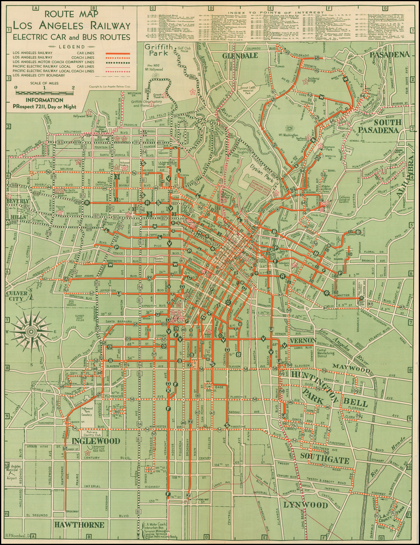
The Vermont–Vernon line was the last new route built by the Los Angeles Railway. Although Henry Huntington had been reluctant to build any cross-town (circumferential) lines, exponential growth along the Wilshire Corridor made it necessary. At the time, Los Angeles had no buses. From Vermont and Beverly, the route ran south on Vermont Avenue to Vernon Avenue, thence east on Vernon to Pacific Boulevard, then east again on Leonis Boulevard to Downey Road in Vernon. [1] A branch line also ran from Vernon Avenue south on Santa Fe Avenue to Slauson Avenue. In 1921, the route was designated as line V. [2] [3]

The line was extended both north and south in 1923. [4] In 1925, plans had been drawn up to extend the Vermont line over 2 miles (3.2 km) further north to Los Feliz Boulevard.[ citation needed ] Instead, the route was extended less than a mile north to Monroe Street and west on Monroe to Heliotrope, on what was then the campus of UCLA (what is now the campus of Los Angeles City College). [5] In 1955, during the Los Angeles Transit Lines era, the Leonis and Santa Fe branches were eliminated; instead the V line ended at a loop called Pacific Crossing, in the center of Vernon. [4]

The V was one of six routes that survived closure and passed into control of the Los Angeles Metropolitan Transit Authority. It was the only cross-town route in the LAMTA era. Streetcar service over the former Los Angeles Railway lines ended after March 31, 1963, [6] with the final scheduled trip made on the V line. [7] [8]

Partial restoration

Vermont Avenue continued its growth, seeded by the robust public transportation provided by the streetcar. The Red Line rapid transit corridor was built underneath the road north of Wilshire by the Los Angeles County Metropolitan Transportation Authority in the early 1990s, reestablishing a new rail service over a portion of the route (albeit underground).

By 2020, the bus lines operating on Vermont had grown to ridership of 45,000 weekday boardings, making it the second busiest corridor in the network. [9] [10] As a result, Los Angeles County Metropolitan Transportation Authority intends to rehabilitate the road for to allow for rapid transit. The corridor extends further south than the old V streetcar and may initially operate as bus rapid transit with more limited service than its progenitor.

Rolling stock

After 1955, PCC streetcars replaced the old rolling stock on the line. [11]

Sources

  1. Walker, Jim (2007). Los Angeles Railway Yellow Cars. Arcadia Pub. p. 84. ISBN   9781531629410.
  2. "May 1: This Date in Los Angeles Transportation History". Metro Dorothy Peyton Gray Transportation Library and Archive. Los Angeles County Metropolitan Transportation Authority. Retrieved February 16, 2022. 1921: Large letter signs indicating the routes of different lines are placed on top of Los Angeles Railway streetcars.
  3. "Cars To Have Letter Signs" (PDF). Two Bells. Vol. 1, no. 48. Los Angeles Railway. May 2, 1921. p. 1. Retrieved February 16, 2022.
  4. 1 2 "'V'". Electric Railway Historical Association of Southern California. Retrieved September 19, 2020.
  5. H.P. Noordwal (1938). "Route Map Los Angeles Railway Electric Car and Bus Routes" (Map). Barry Lawrence Ruderman Antique Maps Inc. Los Angeles Railway. "Alternate link" (Map). via Google .
  6. "March 31: This Date in Los Angeles Transportation History". Dorothy Peyton Gray Transportation Library and Archive. Los Angeles County Metropolitan Transportation Authority. Retrieved February 16, 2021.
  7. "Streetcars Go for Last Ride". Los Angeles Times . March 31, 1963. p. N5.
  8. Creason, Glen (April 29, 2015). "CityDig: This 1938 Map Captures the Charm of L.A.'s Under-Appreciated Yellow Cars". Los Angeles Magazine. Retrieved January 23, 2021.
  9. Tinoco, Matt (May 7, 2018). "A subway on Vermont? Metro is considering it". Curbed LA. Retrieved August 19, 2020.
  10. Next stop: a new kind of bus ride on Vermont (PDF). Amazon Naws (Report). Metro. Retrieved August 19, 2020.
  11. "No.1080 Los Angeles Transit Lines". Market Street Railway . Retrieved January 23, 2021.


Related Research Articles

<span class="mw-page-title-main">Pacific Electric</span> Southern California transit company

The Pacific Electric Railway Company, nicknamed the Red Cars, was a privately owned mass transit system in Southern California consisting of electrically powered streetcars, interurban cars, and buses and was the largest electric railway system in the world in the 1920s. Organized around the city centers of Los Angeles and San Bernardino, it connected cities in Los Angeles County, Orange County, San Bernardino County and Riverside County.

<span class="mw-page-title-main">Crenshaw Boulevard</span> Major street in Los Angeles

Crenshaw Boulevard is a north-south thoroughfare in Los Angeles, California, United States, that runs through Crenshaw and other neighborhoods along a 23-mile route in the west-central part of the city.

<span class="mw-page-title-main">Vermont Avenue</span> Major thoroughfare in Los Angeles, CA

Vermont Avenue is one of the longest running north–south streets in City of Los Angeles and Los Angeles County, California. With a length of 23.3 miles (37.5 km), is the third longest of the north–south thoroughfares in the region. For most of its length between its southern end in San Pedro and south of Downtown Los Angeles, it runs parallel to the west of the Harbor Freeway (I-110).

J was a streetcar line in Los Angeles, California. It was operated by the Los Angeles Railway from 1911 to 1945, by Los Angeles Transit Lines from 1945 to 1958, and by the Los Angeles Metropolitan Transit Authority from 1958 to 1963.

<span class="mw-page-title-main">P (Los Angeles Railway)</span>

P was a streetcar line in Los Angeles, California. It was operated by the Los Angeles Railway from 1895 to 1958, and by the Los Angeles Metropolitan Transit Authority from 1958 to 1963.

R was a streetcar line in Los Angeles, California. It was operated by the Los Angeles Railway and its immediate corporate successor, Los Angeles Transit Lines, from 1895 to 1958, and by the Los Angeles Metropolitan Transit Authority from 1958 to 1963.

S was a streetcar line in Los Angeles, California. It was operated by the Los Angeles Railway from 1895 to 1958, and by the Los Angeles Metropolitan Transit Authority from 1958 to 1963. The route was very popular due to its proximity to Hollywood as well as the sizable manufacturing district in South Los Angeles.

5 or the 5 Car was a streetcar line operated by the Los Angeles Railway, later named the Los Angeles Transit Lines, and by the Los Angeles Metropolitan Transit Authority. From 1920 to 1932, this route was known as the E Car. This was changed as part of a method to distinguish routes that lacked loops at their termini. Consequently, the 5 Car was unique during the LAMTA era in that it did not use PCC streetcars. It used buses from 1955 to 1964, transferring from LATL in 1958, then splitting the line in two in 1961, until all lines were turned over to SCRTD in August 1964.

<span class="mw-page-title-main">7 (Los Angeles Railway)</span> Streetcar route (1932–1955)

7 was a streetcar line in Los Angeles, California. The service was operated by the Los Angeles Railway from 1932 to 1955. It ran from Spring and 2nd Streets to Athens and 116th Street, by way of Spring Street, Main Street, Broadway Place, Broadway, and Athens Way. During its Los Angeles Transit Lines days, around 1950 to 1955, Line 7 was rerouted off South Broadway to Central Avenue, at least as far north as 7th Street across Olympic Boulevard to possibly Vernon Avenue, covering trackage that was abandoned rail by line U, when that line was converted to trolley bus August 3, 1947.

F was a streetcar line in Los Angeles, California. It was operated by the Los Angeles Railway from 1911 to 1955.

<span class="mw-page-title-main">N (Los Angeles Railway)</span>

N was a streetcar line in Los Angeles, California. It was operated by the Los Angeles Railway from 1920 to 1950. The line ran from Spring and 2nd Streets to 8th Street and Western Avenue, by way of Spring Street, 9th Street, Vermont Avenue, and 8th Street.

<span class="mw-page-title-main">W (Los Angeles Railway)</span>

W was a streetcar line in Los Angeles, California. It was operated by the Los Angeles Railway (LARy) from 1895 to 1956.

3 was the number assigned to two distinct streetcar lines operated by the Los Angeles Railway in Los Angeles, California. Combined, they operated from 1924 to 1947.

The B was a streetcar line in Los Angeles, California. It was operated by the Los Angeles Railway from 1920 to 1948, originally running from Ramona Boulevard and Miller Street in East Los Angeles to Ascot Avenue and 51st Street.

G refers to several streetcar routes in Los Angeles, California that ran via Griffith Avenue. The lines were operated by the Los Angeles Railway from 1910 to 1946.

O was a streetcar line in Los Angeles, California. It was operated by the Los Angeles Railway and ran until 1947.

2 was a designation given to several transit lines in Los Angeles, California. The number was assigned to a streetcar route in 1930 which lasted a year, then later reassigned to a new service in 1932. Trolley buses replaced streetcars on a 3rd line in 1948, and the line was converted to full motor coach operation in 1963.

The Vermont Transit Corridor is a proposed 12.5-mile (20.1 km) bus rapid transit line in the Metro Busway network in Los Angeles, California with plans to convert it to a heavy rail subway line in the future. It is planned to operate on a north-to-south route on Vermont Avenue between the B Line's Vermont/Sunset station and the C Line's Vermont/Athens station on the Los Angeles Metro Rail system. The project feasibility study was released in February 2019 with a proposed completion date of 2028 for BRT and after 2067 for rail. It is part of Metro's Twenty-eight by '28 initiative and is partially funded by Measure M. The route will have signal priority at traffic lights and will have a dedicated right of way. Metro reports the initial cost is $425 million.

Pico/Rimpau is an area of Mid-City, Los Angeles, at the junction of Pico Boulevard, Rimpau Street, San Vicente Boulevard, Venice Boulevard, Vineyard Avenue and West Boulevard. This area is the location of several key former and current transportation hubs and retail shopping centers for the Los Angeles area.

K was a streetcar line in Los Angeles, California. It was operated by the Los Angeles Railway from 1913 to 1941.