Following the Great Merger of 1911, control of the route returned to the Los Angeles Railway. They extended the route north and east along Evergreen and Wabash Avenues to the city limits in 1915.[3]
Expansion and later removal (1911–1949)
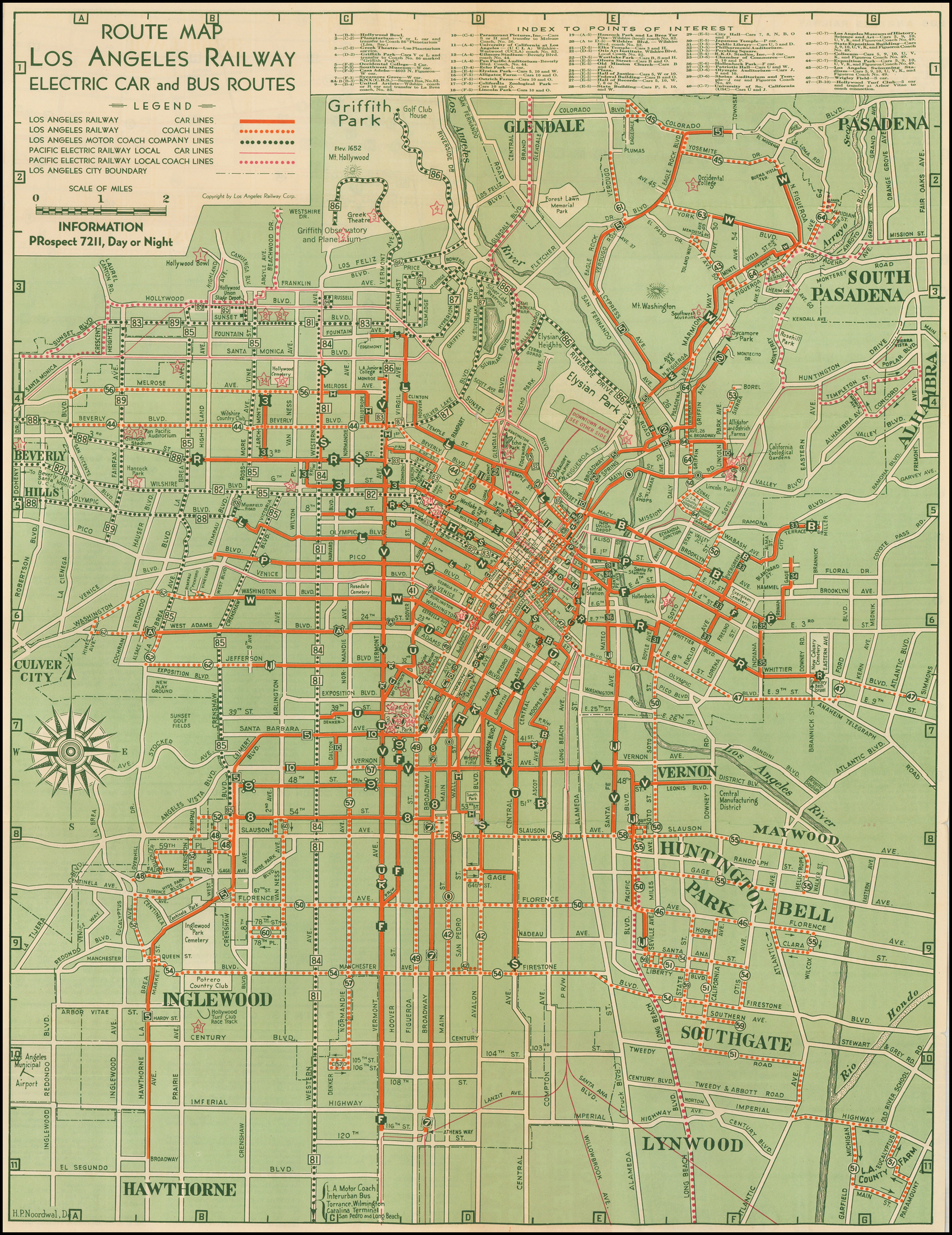
The line was rerouted on May 9, 1920[4] and given the letter designation B the following year.[5][6] Tracks on 9th Street were taken over by the N Line and the remaining service was merged with the Ascot Line, a previously unconnected route which ran by way of Main Street, 12th Street, Hooper Avenue, a private right-of-way alongside the Santa Monica Air Line, and Ascot Avenue.[7][3] (A section of this, between Adams Boulevard and 41st Street, has since been filled in.)[citation needed]
In 1924, rush hour trips were extended northeast along the newly built Harrison Street (later Ramona Boulevard, and later still City Terrace Drive) to Alma Street in East Los Angeles.[3] Completion of the Macy Street Bridge in April 1926 allowed through-routing to Brooklyn Heights.[8] The line began serving Union Station upon its opening in 1939.[9] The final extension of the line was north to City Terrace and Miller Street on March 13, 1931.[3][10] Streetcars were replaced with trolleybuses on December 5, 1948.[11]
↑ "May 1: This Date in Los Angeles Transportation History". Metro Dorothy Peyton Gray Transportation Library and Archive. Los Angeles County Metropolitan Transportation Authority. Retrieved February 16, 2022. 1921: Large letter signs indicating the routes of different lines are placed on top of Los Angeles Railway streetcars.
↑ "Cars To Have Letter Signs"(PDF). Two Bells. Vol.1, no.48. Los Angeles Railway. May 2, 1921. p.1. Retrieved February 16, 2022.
The Pasadena Short Line was a passenger railway line of the Pacific Electric Railway. It ran between Downtown Los Angeles and Downtown Pasadena, California, through Eastside Los Angeles along the foot of the eastern San Rafael Hills to the western San Gabriel Valley. It was in service under the company between 1902 until 1951, though it had operated under different companies back to its beginnings as a horsecar line. The route, designated by the company as line 2, was the key component of the company's Northern Subdivision.
The Upland–San Bernardino Line was an interurban line operated by the Pacific Electric Railway between Downtown Los Angeles and San Bernardino, California. This line also had shorter service that terminated before the end of the line at Baldwin Park, Covina, and San Dimas. Though service along this line in its entirety was discontinued in November 1941, it stands as the fourth-longest rapid transit line in American history, after the Sacramento Northern Railway's Chico and Colusa services, and the Pacific Electric's own Riverside–Rialto Line.
J was a streetcar line in Los Angeles, California. It was operated by the Los Angeles Railway from 1911 to 1945, by Los Angeles Transit Lines from 1945 to 1958, and by the Los Angeles Metropolitan Transit Authority from 1958 to 1963.
P was a streetcar line in Los Angeles, California, United States. It was operated by the Los Angeles Railway from 1895 to 1958, and by the Los Angeles Metropolitan Transit Authority from 1958 to 1963.
R was a streetcar line in Los Angeles, California. It was operated by the Los Angeles Railway and its immediate corporate successor, Los Angeles Transit Lines, from 1895 to 1958, and by the Los Angeles Metropolitan Transit Authority from 1958 to 1963.
V was a streetcar service in Los Angeles, California. It was operated by the Los Angeles Railway from 1920 to 1958, and by the Los Angeles Metropolitan Transit Authority from 1958 to 1963.
S was a streetcar line in Los Angeles, California. It was operated by the Los Angeles Railway from 1895 to 1958, and by the Los Angeles Metropolitan Transit Authority from 1958 to 1963. The route was very popular due to its proximity to Hollywood as well as the sizable manufacturing district in South Los Angeles.
5 or the 5 Car was a streetcar line operated by the Los Angeles Railway, later named the Los Angeles Transit Lines, and by the Los Angeles Metropolitan Transit Authority. From 1920 to 1932, this route was known as the E Car. This was changed as part of a method to distinguish routes that lacked loops at their termini. Consequently, the 5 Car was unique during the LAMTA era in that it did not use PCC streetcars. It used buses from 1955 to 1964, transferring from LATL in 1958, then splitting the line in two in 1961, until all lines were turned over to SCRTD in August 1964.
7 was a streetcar line in Los Angeles, California. The service was operated by the Los Angeles Railway from 1932 to 1955. It ran from Spring and 2nd Streets to Athens and 116th Street, by way of Spring Street, Main Street, Broadway Place, Broadway, and Athens Way. During its Los Angeles Transit Lines days, around 1950 to 1955, Line 7 was rerouted off South Broadway to Central Avenue, at least as far north as 7th Street across Olympic Boulevard to possibly Vernon Avenue, covering trackage that was abandoned rail by line U, when that line was converted to trolley bus August 3, 1947.
8 was a streetcar line in Los Angeles, California. It was operated by the Los Angeles Railway from 1932 to 1955.
9 was a streetcar line in Los Angeles, California. It was operated by the Los Angeles Railway from 1932 to 1955.
F was a streetcar line in Los Angeles, California. It was operated by the Los Angeles Railway from 1911 to 1955.
N was a streetcar line in Los Angeles, California. It was operated by the Los Angeles Railway from 1920 to 1950. The line ran from Spring and 2nd Streets to 8th Street and Western Avenue, by way of Spring Street, 9th Street, Vermont Avenue, and 8th Street.
W was a streetcar line in Los Angeles, California. It was operated by the Los Angeles Railway (LARy) from 1895 to 1956.
U was a streetcar line in Los Angeles, California. Also referred to as the University Line, it provided service to the University of Southern California.
A refers to several streetcar routes in Los Angeles, California. The lines were operated by the Los Angeles Railway and its successor, Los Angeles Transit Lines, from 1920 to 1946.
K was a streetcar line in Los Angeles, California. It was operated by the Los Angeles Railway from 1913 to 1941.
L was a streetcar line in Los Angeles, California. It was operated by the Los Angeles Railway from 1920 to 1940.
M refers to several streetcar routes in Los Angeles, California. The lines were operated by the Los Angeles Railway from 1917 to 1941.
The Venice Boulevard Line was a local streetcar line of the Pacific Electric. It operated between Downtown Los Angeles and Vineyard Junction, where riders could transfer to interurban cars. Nearly all Venice Short Line cars did not accept local passengers, leaving this as the primary streetcar service along its namesake boulevard.
This page is based on this Wikipedia article Text is available under the CC BY-SA 4.0 license; additional terms may apply. Images, videos and audio are available under their respective licenses.


