J (Los Angeles Railway)

Last updated

J
Logo Los Angeles Metropolitan Transit Authority.svg
Overview
Owner Los Angeles Metropolitan Transit Authority
LocaleLos Angeles, Vernon, Huntington Park, and Walnut Park
Termini
Stations82
Service
Type Streetcar
System Los Angeles Railway
Los Angeles Metropolitan Transit Authority
History
Opened1920
ClosedMarch 31, 1963 (March 31, 1963)
Technical
Track gauge 3 ft 6 in (1,067 mm)
Electrification 600 V DC overhead line
Route map

Contents

1962–1963
BSicon uWSL+r.svg
Jefferson and 10th Avenue
BSicon uHST.svg
Jefferson and 7th Avenue
BSicon uHST.svg
Jefferson and 4th Avenue
BSicon uHST.svg
Jefferson and Arlington
BSicon uHST.svg
Jefferson and Cimarron
BSicon uHST.svg
Jefferson and St. Andrews
BSicon uHST.svg
Jefferson and Western
BSicon uHST.svg
Jefferson and Denker
BSicon uHST.svg
Jefferson and Normandie
BSicon uHST.svg
Jefferson and Budlong
BSicon uCONTgq.svg
BSicon uHST.svg
BSicon uKRZ.svg
BSicon uCONTfq.svg
Jefferson and Vermont
  V  
BSicon uHST.svg
Jefferson and McClintock
BSicon uHST.svg
Jefferson and Hoover
BSicon uHST.svg
Jefferson and Figueroa
BSicon uHST.svg
Jefferson and Flower
BSicon uSKRZ-G4u.svg
BSicon uCONTgq.svg
BSicon ul-HST.svg
BSicon ucSTRq.svg
BSicon udABZg+r.svg
Jefferson and Grand
  5  
BSicon uHST.svg
Grand and 30th
BSicon uHST.svg
Grand and 27th
BSicon uHST.svg
Grand and Adams
BSicon uHST.svg
Grand and 23rd
BSicon uHST.svg
Grand and 21st
BSicon uHST.svg
Grand and Washington
BSicon uHST.svg
Grand and 18th
BSicon uHST.svg
Grand and 14th
BSicon uHST.svg
BSicon ud-STRl.svg
BSicon uc-STRq.svg
BSicon u-CONTfq.svg
Grand and Pico
  5  
BSicon uHST.svg
Grand and 12th
BSicon uHST.svg
Grand and 11th
BSicon uHST.svg
Grand and Olympic
BSicon uHST.svg
Grand and 8th
BSicon uHST.svg
BSicon udSTR+l-.svg
BSicon ucSTRq-.svg
BSicon uCONTfq-.svg
7th and Grand
  R    S  
BSicon uHST.svg
7th and Olive
BSicon uHST.svg
7th and Hill
BSicon uCONTgq.svg
BSicon uHST.svg
BSicon uKRZ.svg
BSicon uCONTfq.svg
7th and Broadway
  P    5  
BSicon uHST.svg
7th and Spring
BSicon uHST.svg
7th and Main
BSicon uHST.svg
7th and Los Angeles
BSicon uHST.svg
7th and Maple
BSicon uHST.svg
BSicon ud-STRl.svg
BSicon uc-STRq.svg
BSicon u-CONTfq.svg
7th and San Pedro
  R  
BSicon uHST.svg
San Pedro and 9th
BSicon uHST.svg
San Pedro and 11th
BSicon uHST.svg
San Pedro and Pico
BSicon uHST.svg
San Pedro and 14th
BSicon uHST.svg
San Pedro and 16th
BSicon uHST.svg
San Pedro and Washington
BSicon uHST.svg
San Pedro and 21st
BSicon uHST.svg
San Pedro and 16th
BSicon uHST.svg
San Pedro and 23rd
BSicon uHST.svg
San Pedro and Adams
BSicon uHST.svg
San Pedro and 30th
BSicon uHST.svg
San Pedro and Jefferson
BSicon uHST.svg
Avalon and Santa Barbara
BSicon uHST.svg
Avalon and 41st
BSicon uHST.svg
Avalon and 42nd
BSicon uCONTgq.svg
BSicon uHST.svg
BSicon uABZgr+r.svg
Avalon and Vernon
  S    V  
BSicon uHST.svg
Vernon and McKinley
BSicon uHST.svg
Vernon and Central
BSicon uHST.svg
Vernon and Hooper
BSicon uHST.svg
Vernon and Ascot
BSicon uHST.svg
Vernon and Compton
BSicon uHST.svg
Vernon and Morgan
BSicon CONTgq.svg
BSicon uINT.svg
BSicon umKRZ.svg
BSicon CONTfq.svg
Vernon and Long Beach
PE Bolt.svg
BSicon uHST.svg
Vernon and Alameda
BSicon uHST.svg
Vernon and St. Charles
BSicon uHST.svg
Vernon and Santa Fe
BSicon uHST.svg
BSicon ud-STRl.svg
BSicon uc-STRq.svg
BSicon u-WSLlq.svg
Pacific Crossing
  V  
BSicon uHST.svg
Pacific and 46th
BSicon uHST.svg
Pacific and Leonis
BSicon uHST.svg
Pacific and Fruitland
BSicon uSTR.svg
BSicon gDOCKS.svg
BSicon uHST.svg
Pacific and 55th
BSicon uHST.svg
Pacific and 57th
BSicon uHST.svg
Pacific and Slauson
BSicon uHST.svg
Pacific and Belgrave
BSicon exCONTgq.svg
BSicon uHST.svg
BSicon exSTRq.svg
BSicon exCONTfq.svg
Pacific and Randolph
PE Bolt.svg
BSicon uHST.svg
Pacific and Gage
BSicon uHST.svg
Pacific and Zoe
BSicon uHST.svg
Pacific and Saturn
BSicon uHST.svg
Pacific and Florence
BSicon uSTR.svg
BSicon gDOCKS.svg
BSicon uHST.svg
Seville and Florence
BSicon uHST.svg
Seville and Live Oak
BSicon uHST.svg
Seville and Grand
BSicon uHST.svg
Seville and Broadway
BSicon uWSLr.svg
Palm Place

J was a streetcar line in Los Angeles, California. It was operated by the Los Angeles Railway from 1911 to 1945, by Los Angeles Transit Lines from 1945 to 1958, and by the Los Angeles Metropolitan Transit Authority from 1958 to 1963.

History

Huntington Line (1895–1911)

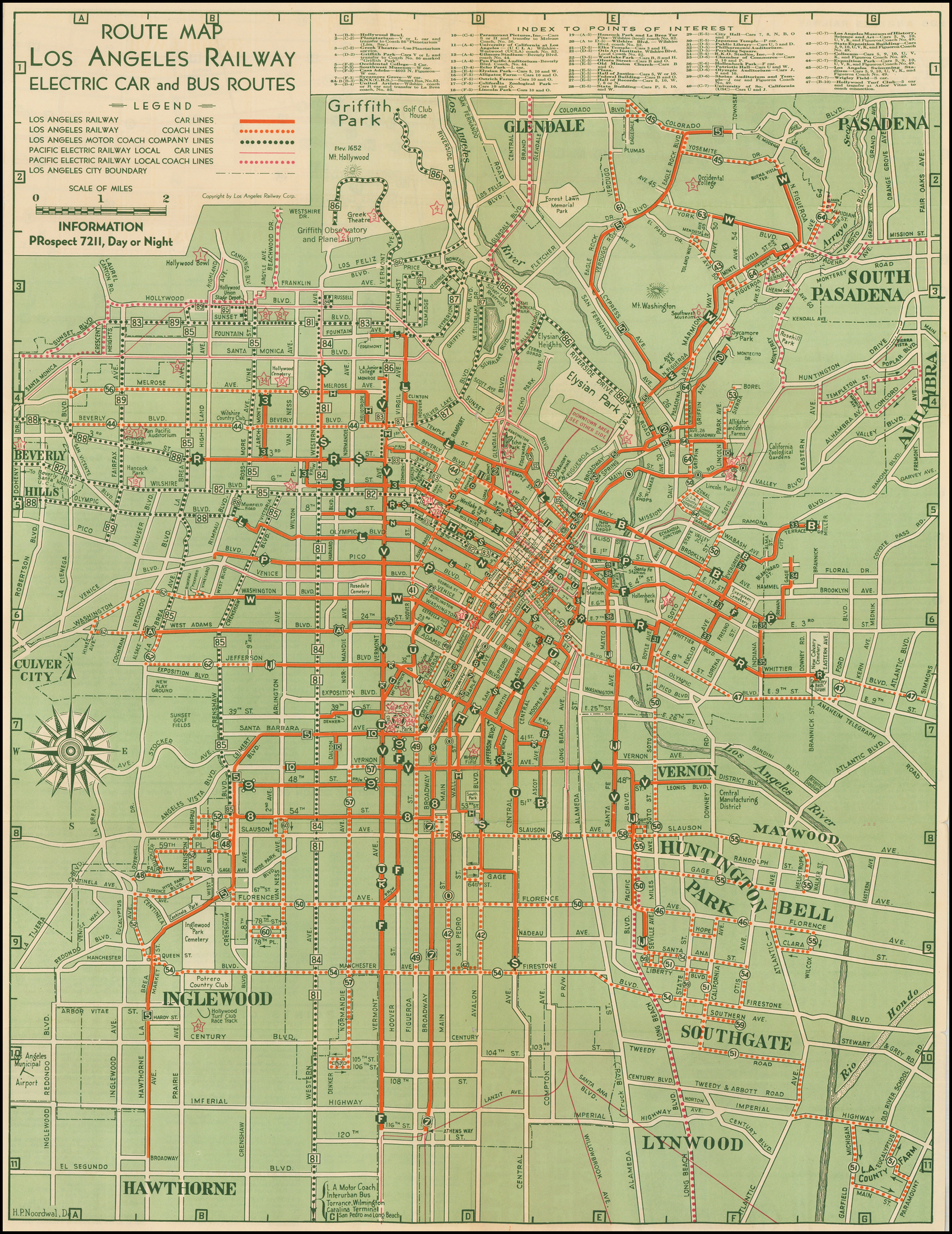
The Huntington Line was one of the original routes of the Los Angeles Railway. From Downtown, it branched off the Pico Line at 1st and Santa Fe. From there, it followed a route south on Santa Fe Avenue, a private right-of-way, Mateo Street, 9th Street, Santa Fe Avenue, Pacific Boulevard, Florence Avenue, and Seville Avenue to Walnut Park, with an additional branch down Santa Fe to Slauson Avenue. After 1911, a shuttle route continued to run on Mateo Street, but the remainder of the route now entered Downtown Los Angeles via 7th Street. [1]

Jefferson Line (1898–1911)

The Jefferson Line was built by the Los Angeles Traction Company, and ran as a meager shuttle route on West Jefferson Boulevard between 4th Avenue and Wesley Avenue (present-day University Avenue) at the University of Southern California, where there were two transfer points for the Los Angeles Railway's University Line. The route was maintained by the Los Angeles Interurban Railway, then the Pacific Electric Railway, who operated the local route until the Great Merger of 1911. From that point on, the Jefferson Line was integrated into the Huntington Line and extended west to 9th Avenue. [1]

J Line (1911–1963)

In 1921, the route became known as "J." [2] [3] The line ran from Jefferson and 9th in the Jefferson Park neighborhood of Los Angeles, [4] to Seville and Santa Ana Streets in Walnut Park. Cars operated by way of West Jefferson Boulevard, South Grand Avenue, 7th Street, Mateo Street, East Olympic Boulevard, South Santa Fe Avenue, Pacific Boulevard, East Florence Avenue, and Seville Avenue. [5] Early on, a short-lived branch line was run east on Jefferson to San Pedro. The line was extended at both ends to new balloon loops in 1939: one at 10th Street and the Palm Place loop. [1]

The service was transferred to the Los Angeles Metropolitan Transit Authority in 1958. In 1962, due to a paving project, rail service east of Seventh and San Pedro was rerouted with a deviation and aligned with the S line south on San Pedro and Avalon, thence left on Vernon through the Jazz District aligned with the V line to Santa Fe Avenue and Pacific Boulevard until service ceased on March 31, 1963. [6] [7] This line contributed to the success of Huntington Park's Pacific Boulevard business district for many years. [1]

Sources

  1. 1 2 3 4 "'J'". Electric Railway Historical Association of Southern California. Retrieved September 19, 2020.
  2. "May 1: This Date in Los Angeles Transportation History". Metro Dorothy Peyton Gray Transportation Library and Archive. Los Angeles County Metropolitan Transportation Authority. Retrieved February 16, 2022. 1921: Large letter signs indicating the routes of different lines are placed on top of Los Angeles Railway streetcars.
  3. "Cars To Have Letter Signs" (PDF). Two Bells. Vol. 1, no. 48. Los Angeles Railway. May 2, 1921. p. 1. Retrieved February 16, 2022.
  4. Walker, Jim (2007). Los Angeles Railway Yellow Cars. Arcadia Pub. p. 104. ISBN   9781531629410.
  5. H.P. Noordwal (1938). "Route Map Los Angeles Railway Electric Car and Bus Routes" (Map). Barry Lawrence Ruderman Antique Maps Inc. Los Angeles Railway. "Alternate link" (Map). via Google .
  6. "March 31: This Date in Los Angeles Transportation History". Dorothy Peyton Gray Transportation Library and Archive. Los Angeles County Metropolitan Transportation Authority. Retrieved February 16, 2021.
  7. LAMTA schedule, Los Angeles Metropolitan Transit Authority, December 23, 1962

Related Research Articles

<span class="mw-page-title-main">Pacific Electric</span> Southern California transit company

The Pacific Electric Railway Company, nicknamed the Red Cars, was a privately owned mass transit system in Southern California consisting of electrically powered streetcars, interurban cars, and buses and was the largest electric railway system in the world in the 1920s. Organized around the city centers of Los Angeles and San Bernardino, it connected cities in Los Angeles County, Orange County, San Bernardino County and Riverside County.

<span class="mw-page-title-main">Los Angeles Railway</span> Electric interurban railway in Los Angeles, California

The Los Angeles Railway was a system of streetcars that operated in Central Los Angeles and surrounding neighborhoods between 1895 and 1963. The system provided frequent local services which complemented the Pacific Electric "Red Car" system's largely commuter-based interurban routes. The company carried many more passengers than the Red Cars, which served a larger and sparser area of Los Angeles.

<span class="mw-page-title-main">Monrovia–Glendora Line</span> Pacific Electric streetcar route (1902–1951)

The Monrovia–Glendora Line was a route on the Pacific Electric Railway serving the San Gabriel Valley. It operated from 1902 to 1951, supporting nearby real estate development.

<span class="mw-page-title-main">Pasadena Short Line</span> Pacific Electric streetcar line (1894–1951)

The Pasadena Short Line was a passenger railway line of the Pacific Electric Railway. It ran between Downtown Los Angeles and Downtown Pasadena, California, through Eastside Los Angeles along the foot of the eastern San Rafael Hills to the western San Gabriel Valley. It was in service under the company between 1902 until 1951, though it had operated under different companies back to its beginnings as a horsecar line. The route, designated by the company as line 2, was the key component of the company's Northern Subdivision.

<span class="mw-page-title-main">Westgate Line</span> Pacific Electric streetcar line (1906–1940)

The Westgate Line was a suburban route operated by the Pacific Electric Railway from 1911 to 1940. This line was one of four lines connecting Downtown Los Angeles and Santa Monica that did not run through Hollywood. The line is notable for taking a circuitous route towards its end, along San Vicente Boulevard, mainly because it was built to encourage construction of new homes near Pacific Palisades.

<span class="mw-page-title-main">Long Beach Line</span> Pacific Electric interurban route in California

The Long Beach Line was a major interurban railway operated by the Pacific Electric Railway between Los Angeles and Long Beach, California via Florence, Watts, and Compton. Service began in 1902 and lasted until 1961, the last line of the system to be replaced by buses.

<span class="mw-page-title-main">P (Los Angeles Railway)</span>

P was a streetcar line in Los Angeles, California. It was operated by the Los Angeles Railway from 1895 to 1958, and by the Los Angeles Metropolitan Transit Authority from 1958 to 1963.

R was a streetcar line in Los Angeles, California. It was operated by the Los Angeles Railway and its immediate corporate successor, Los Angeles Transit Lines, from 1895 to 1958, and by the Los Angeles Metropolitan Transit Authority from 1958 to 1963.

V was a streetcar service in Los Angeles, California. It was operated by the Los Angeles Railway from 1920 to 1958, and by the Los Angeles Metropolitan Transit Authority from 1958 to 1963.

S was a streetcar line in Los Angeles, California. It was operated by the Los Angeles Railway from 1895 to 1958, and by the Los Angeles Metropolitan Transit Authority from 1958 to 1963. The route was very popular due to its proximity to Hollywood as well as the sizable manufacturing district in South Los Angeles.

5 or the 5 Car was a streetcar line operated by the Los Angeles Railway, later named the Los Angeles Transit Lines, and by the Los Angeles Metropolitan Transit Authority. From 1920 to 1932, this route was known as the E Car. This was changed as part of a method to distinguish routes that lacked loops at their termini. Consequently, the 5 Car was unique during the LAMTA era in that it did not use PCC streetcars. It used buses from 1955 to 1964, transferring from LATL in 1958, then splitting the line in two in 1961, until all lines were turned over to SCRTD in August 1964.

<span class="mw-page-title-main">7 (Los Angeles Railway)</span> Streetcar route (1932–1955)

7 was a streetcar line in Los Angeles, California. The service was operated by the Los Angeles Railway from 1932 to 1955. It ran from Spring and 2nd Streets to Athens and 116th Street, by way of Spring Street, Main Street, Broadway Place, Broadway, and Athens Way. During its Los Angeles Transit Lines days, around 1950 to 1955, Line 7 was rerouted off South Broadway to Central Avenue, at least as far north as 7th Street across Olympic Boulevard to possibly Vernon Avenue, covering trackage that was abandoned rail by line U, when that line was converted to trolley bus August 3, 1947.

9 was a streetcar line in Los Angeles, California. It was operated by the Los Angeles Railway from 1932 to 1955.

F was a streetcar line in Los Angeles, California. It was operated by the Los Angeles Railway from 1911 to 1955.

<span class="mw-page-title-main">N (Los Angeles Railway)</span>

N was a streetcar line in Los Angeles, California. It was operated by the Los Angeles Railway from 1920 to 1950. The line ran from Spring and 2nd Streets to 8th Street and Western Avenue, by way of Spring Street, 9th Street, Vermont Avenue, and 8th Street.

3 was the number assigned to two distinct streetcar lines operated by the Los Angeles Railway in Los Angeles, California. Combined, they operated from 1924 to 1947.

The B was a streetcar line in Los Angeles, California. It was operated by the Los Angeles Railway from 1920 to 1948, originally running from Ramona Boulevard and Miller Street in East Los Angeles to Ascot Avenue and 51st Street.

G refers to several streetcar routes in Los Angeles, California that ran via Griffith Avenue. The lines were operated by the Los Angeles Railway from 1910 to 1946.

Pico/Rimpau is an area of Mid-City, Los Angeles, at the junction of Pico Boulevard, Rimpau Street, San Vicente Boulevard, Venice Boulevard, Vineyard Avenue and West Boulevard. This area is the location of several key former and current transportation hubs and retail shopping centers for the Los Angeles area.

<span class="mw-page-title-main">M (Los Angeles Railway)</span> Streetcar routes in Los Angeles, California (1917 to 1941)

M refers to several streetcar routes in Los Angeles, California. The lines were operated by the Los Angeles Railway from 1917 to 1941.