Rancho Cucamonga is a city located just south of the foothills of the San Gabriel Mountains and Angeles National Forest in San Bernardino County, California, United States. About 37 mi (60 km) east of Downtown Los Angeles, Rancho Cucamonga is the 28th most populous city in California. The city's seal, which centers on a cluster of grapes, alludes to the city's agricultural history including wine-making. The city's proximity to major transportation hubs, airports, and highways has attracted the business of several large corporations, including Coca-Cola, Frito-Lay, Big Lots, Mercury Insurance Group, Southern California Edison, and Amphastar Pharmaceuticals.

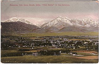
The Pomona Valley is located in the Greater Los Angeles Area between the San Gabriel Valley and San Bernardino Valley in Southern California. The valley is approximately 30 miles (48 km) east of downtown Los Angeles.

Rancho Cucamonga was a 13,045-acre Mexican land grant in present-day San Bernardino County, California, given in 1839 to the dedicated soldier, smuggler and politician Tiburcio Tapia by Mexican governor Juan Bautista Alvarado. The grant formed parts of present-day California cities Rancho Cucamonga and Upland. It extended easterly from San Antonio Creek to what is now Hermosa Avenue, and from today's Eighth Street to the mountains.

The Cucamonga Valley is a region of southwestern San Bernardino County and northwestern Riverside County, in southern California. It is located below the San Gabriel Mountains in the Inland Empire region.

The San Bernardino Valley is a valley in Southern California located at the south base of the Transverse Ranges. It is bordered on the north by the eastern San Gabriel Mountains and the San Bernardino Mountains; on the east by the San Jacinto Mountains; on the south by the Temescal Mountains and Santa Ana Mountains; and on the west by the Pomona Valley. Elevation varies from 590 feet (180 m) on valley floors near Chino to 1,380 feet (420 m) near San Bernardino and Redlands. The valley floor is home to over 80% of the more than 4 million people in the Inland Empire region.

Cucamonga Peak is one of the highest peaks of the San Gabriel Mountains in San Bernardino County, California, with a summit elevation of 8,862 feet (2,701 m). It is within the Cucamonga Wilderness of the San Bernardino National Forest.

Alta Loma is one of three unincorporated areas that became part of the city of Rancho Cucamonga, California, United States in 1977. The community is located at 34.15°N 117.60°W in the foothills of the south face of the San Gabriel Mountain range, near Cucamonga Peak and Mount San Antonio. Its ZIP codes are 91701 and 91737. Elevation ranges from 1,400 feet (430 m) to 3,000 feet (910 m). The name comes from the Spanish words for "high hill." Alta Loma had previously been known as "Iamosa".

The Cucamonga Valley AVA is an American Viticultural Area in San Bernardino County, California. It is in the Cucamonga Valley region of the Pomona Valley, about 15 miles (24 km) west of San Bernardino.

San Timoteo Canyon is a river valley canyon southeast of Redlands, in the far northwestern foothills of the San Jacinto Mountains in the Inland Empire region of Southern California.

The San Bernardino County Sheriff-Coroner's Department (SBSD) serves San Bernardino County, California, which is geographically the largest county in the United States and is headquartered in San Bernardino city. SBSD provides law enforcement services to the unincorporated areas of the county and contract law enforcement services to 14 of the county's cities, including Rancho Cucamonga and Chino Hills, serving a total of 1,029,466 of the county's 2 million residents. The department also operates the county jail system, provides marshal services for the county superior courts, and has numerous other specialized divisions to serve the citizens of San Bernardino County.
Guasti, formerly known as South Cucamonga and Zucker, is a formerly unincorporated community in the Cucamonga Valley region of the Pomona Valley, in southwestern San Bernardino County, California.
Tom McCauley, better known by his alias James Henry or Jim Henry, was one of the many California Gold Rush criminals later a leader of the Mason Henry Gang.

Railroad Canyon, originally named San Jacinto Canyon, also known as Cottonwood Canyon, and Annie Orton Canyon, is a valley located in Riverside County, California. It encloses the lower course of the San Jacinto River at the point where the river passes south through the Temescal Mountains from a point 6 miles south-southwest of Perris, California, through Canyon Lake, California, then west to Lake Elsinore, California. The canyon has its present name from the California Southern Railroad that was constructed down the canyon in 1882.

Don Pedro Sainsevain was a French-born Californian vintner, ranchero, and a signer of the Californian Constitution in 1849. He is best known for his role in Californian winemaking, as one of the first producers of sparkling wine in California. He also was an early participant in the California Gold Rush.
Rancho Cañada del Rincon en el Rio San Lorenzo was a 5,827-acre (23.58 km2) Mexican land grant in present-day Santa Cruz County, California given in 1843 by Governor Manuel Micheltorena, and confirmed in 1846 by Governor Pío Pico, to Pedro Sainsevain. The name means "valley on a corner on the San Lorenzo River". The grant was north of present-day Santa Cruz on the San Lorenzo River.
Juan Antonio (1783–1863), Cahuilla name: Cooswootna, Yampoochee,, was a major chief of the Mountain Band of the Cahuilla from the 1840s to 1863.
Joseph Franklin Dye (1831–1891) was an American forty-niner and alleged member of the Mason Henry Gang. He was also a rancher and early oilman in Southern California.
The Mason Henry Gang were bandits operating in Central and Southern California in 1864–1865. As the Civil War was in progress, they were able to pose as Confederate Partisan Rangers, and their original mission was to rid the area of (anti-slavery) Republicans. But when it became clear that the Confederate cause was lost, they turned to outlawry, plundering and killing without mercy.
Benjamin Franklin Mathews (1819–1888) was elected Sheriff of San Bernardino County, California on September 14, 1863 and served from October, 1863 to October, 1865. Mathews was born April 16, 1819 in Chattanooga, Hamilton County, Tennessee. He arrived in Salt Lake in 1847 with Mormons, from Mississippi. He moved on to California in 1850, where he kept a hotel between Sacramento and Auburn. Mathews came south to arrive in the Mormon colony of San Bernardino, on March 30, 1852. Here he was at various times a teamster, miller, Justice of the Peace and finally sheriff. Unlike many Mormons in San Bernardino he did not return to Utah during the Utah War in 1857.

Tapia Adobe was the home of Tiburcio Tapia (1789–1845). Tiburcio Tapia was a Mexican soldier, politician, then became a merchant, winery owner and ranch owner, in what is now Cucamonga, California. The place of Tapia Adobe (home) was designated a California Historic Landmark (No.360) on October 9, 1939. Tiburcio Tapía received the land to built his Adobe and Rancho Cucamonga from a 1839 13,045-acre (52.79 km2) Mexican land grant in present-day San Bernardino County, California The land grant was from Mexican governor Juan Bautista Alvarado. The grant formed parts of present-day Rancho Cucamonga and Upland. It extended easterly from San Antonio Creek to what is now Hermosa Avenue, and from today's Eighth Street to the mountains.


