
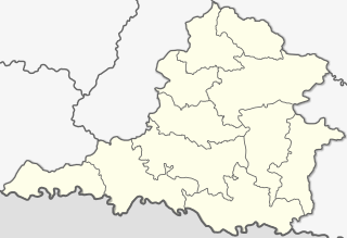
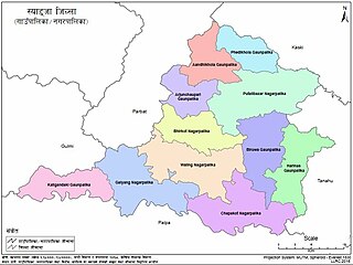
Syangja District, a part of Gandaki Province, is one of the seventy-seven districts of Nepal. The district, with Syangja bazaar as its district headquarters, covers an area of 1,164 km2 (449 sq mi) and had a population of 289,148 It lies in the hilly region at an altitude ranging from about 300 meters along the banks of Kaligandaki river up to a couple of thousands meters above the sea level. It lies at about latitude 28°4'60 North and longitude 83°52'0 East.

Putalibazar, is a municipality and district headquarters in Syangja District in Gandaki Province of central Nepal. Putalibazar is a famous city of Syangja District.

Devghat(Sanskrit: देवघाटम्, DevaghāṭamSanskrit pronunciation: [deːʋɐˈɡʱaːʈɐm]) is one of the famous religious and cultural centers in central Nepal. At the time of the 1991 Nepal census it had a population of 5786 people living in 1132 individual households.

Biruwa Archale is a village development committee in Syangja District in the Gandaki Zone of central Nepal. At the time of the 2011 Nepal census it had a population of 2860 people living in 674 individual households. ward no. 1 Dara/Besardada village is 100% Gurung Village. While the other Ward No. 2 Shree Danda and the remaining Ward No. 3-9 consists of Magar, Chhetri and Brahmins.
Chapakot is a municipality in the southeastern part of Syangja District in Gandaki Province of central Nepal. The new municipality was formed by merging three existing villages—Ratnapur, Kuwakot and Chapakot—on 18 May 2014. In 12 March 2017 The government implemented the new local administrative structure consisting of 744 local units. With the implementation of this new local administrative structure, the old structure will no longer be in existence. According to the new structure, VDCs will be replaced with village councils. Newly merged VDCs are Sankhar, Sekham, Ward no. 8 of Pakbadi & Ward no. of Malengkot. The office of the municipality is that of the former Chapakot Municipality.

Rampur is a municipality in Palpa District in Lumbini Province of West southern Nepal. According to hindu mythology, Maharishi Vasistha taught Yogavasistha to lord Rama in the cave of Rampur. Rampur is 65 km northeast from the headquarter city Tansen. The valley is bounded by Syangja District in the north, Tanahun District in the northeast, and Nawalparasi District in the east. The popular religious river Kaligandaki disconnects the boundary in the northern part.

Majuwa is a village in Sankhar VDC, Ward No. 6, Syangja District, Gandaki Zone, Nepal. At the time of the Nepal Census 2011, it had a population of 551 people residing in 146 individual households. Dihi, Ambote, Devithan such are sub-localities of this village.
Giruwari is one of the village located in north part of Nawalparasi district of Lumnini Zone in the western development region of Nepal. Lumbinī is a Buddhist pilgrimage site in the Rupandehi district of Nepal.[1] It is the place where Queen Mayadevi gave birth to Siddhartha Gautama, who is the Buddha. Gautama founded the Buddhist tradition. Buddha lived between roughly 563 and 483 BC. Lumbini is one of four magnets for pilgrimage that sprang up in places pivotal to the life of the Buddha, the others being at Kushinagar, Bodh Gaya and Sarnath.

The Seti Gandaki River, also known as the Seti River or the Seti Khola, is a river of western Nepal, a left tributary of the Trishuli River. Its gorges around Pokhara are a major attraction for tourists worldwide.
Bhattarai Danda Nepali: भट्टराई डाँडा is a City in Syangja District in Nepal. Majority of its people are Brahmins and they are Bhattarai families, so the entire village is named accordingly. According to the 2011 Nepal census, held by Central Bureau of Statistics, it had a total population of 5510. There are 2,610 males and 2,800 females living in 846 households.
Keladi is a village in Sankhar VDC at Ward No-6, Nepal.

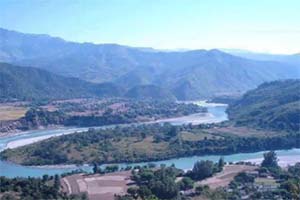
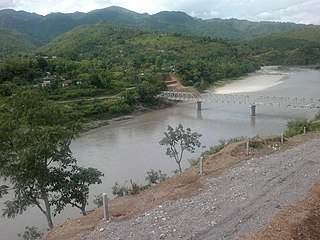
Keladighat Bridge is a motor-able bridge over Kali Gandaki river in Keladighat of Syangja District, Gandaki Zone and Gandakidhik of Palpa District, Lumbini Zone, Western Region, Nepal. 166.6 meter long and 4.25 meter wide bridge is completed now.
Panglung is a village in Sankhar village development committee Ward No-7, Syangja District, Gandaki Province, Nepal. The majority of its people are Brahmins. At the 2011 Nepal census, it had a population of 541, with 261 males and 280 females living in 46 households.
Salghari is a village in Sankhar village development committee Ward No-5, Syangja District, Gandaki Province, Nepal. According to the 2011 Nepal census, held by Central Bureau of Statistics, it had a total population of 41. There are 20 males and 21 females living in 12 households.
Murchaur is a village in Sankhar village development committee Ward No-9, Syangja District, Gandaki Zone, Nepal. According to the 2011 Nepal census, held by Central Bureau of Statistics, it had a total population of 241.
Manechaur is a village in Sankhar village development committee Ward No-4, Syangja District, Gandaki Zone, Nepal. According to the 2011 Nepal census, held by Central Bureau of Statistics, it had a total population of 201.
Galyang is a Municipality in Syangja District in Gandaki Province, central Nepal. In 12 March 2017, The government of Nepal implemented the new local administrative structure consisting of 744 local units. With the implementation of this new local administrative structure, VDCs have been replaced with village councils. Galyang is one of these 744 local municipal units. Galyang is created by merging Malunga, Jagatradevi, (1-6,9) Wards of Pakwadi, (1,6-9) Wards of Tindobate, Tulsibhanjyang, Nibuwakharka, Pindikhola, Batuwa & (1-4,7-9) Wards of Pelakot.
Biruwa is a Village council in Syangja District in Gandaki Province, central Nepal.
Harinas is a Village council in Syangja District in Gandaki Province, central Nepal.
Mohami is a City of Sankhar in Chapakot of Syangja District of Gandaki Province in Nepal. At the time of the 2011 Nepal census, it had a population of 339 people residing in 75 individual households.


