The recorded history of Cape Verde begins with Portuguese discovery in 1456. Possible early references go back around 2000 years.
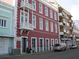
Praia is the capital and largest city of Republic of Cabo Verde. Located on the southern coast of Santiago island, within the Sotavento Islands group, the city is the seat of the Praia Municipality. Praia is the economic, political, and cultural center of Cabo Verde.

Fogo is an island in the Sotavento group of Cape Verde. Its population is 35,837 (2015), with an area of 476 km². It reaches the highest altitude of all the islands in Cape Verde, rising to 2,829 metres above sea level at the summit of its active volcano, Pico do Fogo.

Brava is an island in Cape Verde, in the Sotavento group. At 62.5 km2 (24.1 sq mi), it is the smallest inhabited island of the Cape Verde archipelago, but at the same time the greenest. First settled in the early 16th century, its population grew after Mount Fogo on neighbouring Fogo erupted in 1680. For more than a century, its main industry was whaling, but the island economy is now primarily agricultural.

Sal is an island in Cape Verde. It belongs to the northern group of islands, called Barlavento ("windwards"), and comprises a single administrative division, the municipality of Sal. Its seat is the city of Espargos.

Boa Vista, also written as Boavista, is a desert-like island that belongs to the Cape Verde Islands. At 631.1 km2 (243.7 sq mi), it is the third largest island of the Cape Verde archipelago.

Espargos is the capital and main commercial centre of the island and municipality of Sal, Cape Verde. The city is situated in the heart of the island.

Ribeira do Ilhéu is a settlement in the northern part of the island of Fogo, Cape Verde. It is situated 6 km west of Mosteiros and 20 km northeast of the island capital São Filipe. The nearest village is Atalaia, 1.5 km to the southwest. The village's main festival is the festival of Saint Joseph that takes place on March 19.

Fajãzinha is a settlement in the northern part of the island of Fogo, Cape Verde. It is situated on the coast, 3 km northwest of Mosteiros and 23 km northeast of the island capital São Filipe. Each year on May 13, the festival of Our Lady of Fatima is celebrated in the settlement.
Terra Boa is a remote village in the northern part of the island of Sal, Cape Verde. In 2010 its population was 131. The village is about 4 km north of the island capital Espargos.

Janela is a settlement in the eastern part of the island of Santo Antão, Cape Verde. It is situated on the Atlantic coast, 4 km southeast of Pombas and 14 km northeast of the island capital Porto Novo The central village, Pontinha, lies on a rocky peninsula. More villages are situated in the valley of the river Ribeira da Janela. The national road from Porto Novo to Pombas (EN1-SA03) passes through Janela.
Sinagoga is a settlement in the northeastern part of the island of Santo Antão, Cape Verde. It is situated on the coast, 4 kilometers east of Ribeira Grande and 18 km north-northeast of the island capital Porto Novo. It is situated on the national road connecting Ribeira Grande and Pombas (EN1-SA02).

Bofarreira is a village in the northern part of the island of Boa Vista in the Cape Verde archipelago. The village is around 10 km east of the island capital of Sal Rei.

Cabeça dos Tarrafes is a village in the eastern part of the island of Boa Vista, Cape Verde. The village is located about 2 km south of Fundo das Figueiras and 21 km southeast of the island capital of Sal Rei. It is one of the easternmost communities in Cape Verde.

Fundo das Figueiras is a village in the eastern part of the island of Boa Vista. The village is around 21 km east of the island capital of Sal Rei. It is the seat of the civil parish of São João Baptista. 2 km to the south is the village Cabeça dos Tarrafes and 8 km southeast is Ponta Meringuel, the easternmost point in Cape Verde.

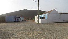
Povoação Velha is a village in the southwestern part of the island of Boa Vista, Cape Verde. The village is around 16 km south of the island capital Sal Rei.
Cape Verde or Cabo Verde, officially the Republic of Cabo Verde, is an island country spanning an archipelago of 10 volcanic islands in the central Atlantic Ocean. It forms part of the Macaronesia ecoregion, along with the Azores, Canary Islands, Madeira, and the Savage Isles. Located 570 kilometres (350 mi) west of the Cape Verde Peninsula off the coast of Northwest Africa, the islands cover a combined area of slightly over 4,000 square kilometres (1,500 sq mi).

Cape Verde was a colony of the Portuguese Empire from the initial settlement of the Cape Verde Islands in 1462 until the independence of Cape Verde in 1975.
Feijoal is a village on the island of Fogo, Cape Verde. It lies close to the town Mosteiros, at about 220 meters elevation. Its population was 435 at the 2010 census. The main festival in the settlement is Saint Anthony which is on June 13.
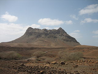
Rocha Estância is a mountain in the southwestern part of the island Boa Vista in Cape Verde, east of the village of Povoação Velha. Its elevation is 357 meters. It is part of a protected area covering 253 ha. The Our Lady of Conception church is located at the western foot of the mountain.