Oaxaca, officially the Free and Sovereign State of Oaxaca, is one of the 32 states that compose the Federative Entities of Mexico. It is divided into 570 municipalities, of which 418 are governed by the system of usos y costumbres with recognized local forms of self-governance. Its capital city is Oaxaca de Juárez.
Oaxaca de Juárez, or simply Oaxaca, is the capital and largest city of the eponymous Mexican state of Oaxaca. It is the municipal seat for the surrounding municipality of Oaxaca. It is in the Centro District in the Central Valleys region of the state, in the foothills of the Sierra Madre at the base of the Cerro del Fortín, extending to the banks of the Atoyac River. Heritage tourism makes up an important part of the city's economy, and it has numerous colonial-era structures as well as significant archeological sites and elements of the continuing native Zapotec and Mixtec cultures. The city, together with the nearby archeological site of Monte Albán, was designated in 1987 as a UNESCO World Heritage Site. It is the site of the month-long cultural festival called the "Guelaguetza", which features Oaxacan dance from the seven regions, music, and a beauty pageant for indigenous women.
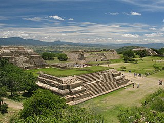
Mitla is the second-most important archeological site in the state of Oaxaca in Mexico, and the most important of the Zapotec culture. The site is located 44 km from the city of Oaxaca, in the upper end of the Tlacolula Valley, one of the three cold, high valleys that form the Central Valleys Region of the state. At an elevation of 4,855 ft, surrounded by the mountains of the Sierra Madre del Sur, the archeological site is within the modern municipality of San Pablo Villa de Mitla. It is 24 mi (38 km) southeast of Oaxaca city. While Monte Albán was the most important politically of the Zapotec centers, Mitla became the main religious one in a later period as the area became dominated by the Mixtec.

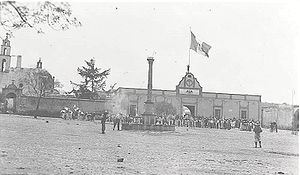
Tehuantepec is a city and municipality in the southeast of the Mexican state of Oaxaca. It is part of the Tehuantepec District in the west of the Istmo Region. The area was important in pre Hispanic period as part of a trade route that connected Central America with what is now the center of Mexico. Later it became a secondary capital of the Zapotec dominion, before it was conquered by the Spanish in the early 16th century.

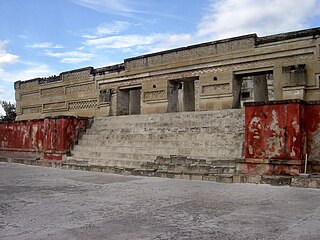
San Pablo Villa de Mitla is a town and municipality in Mexico which is most famous for being the site of the Mitla archeological ruins. It is part of the Tlacolula District in the east of the Valles Centrales Region. The town is also known for its handcrafted textiles, especially embroidered pieces and mezcal. The town also contains a museum which was closed without explanation in 1995, since when its entire collection of Zapotec and Mixtec cultural items has disappeared. The name “San Pablo” is in honor of Saint Paul, and “Mitla” is a hispanization of the Nahuatl name “Mictlán.” This is the name the Aztecs gave the old pre-Hispanic city before the Spanish arrived and means “land of the dead.” It is located in the Central Valleys regions of Oaxaca, 46 km from the city of Oaxaca, in the District of Tlacolula.
The Chatinos are an indigenous people of Mexico. Chatino communities are located in the southeastern region of the state of Oaxaca in southern central Mexico. Their native Chatino language are spoken by about 23,000 people, but ethnic Chatinos may number many more. The Chatinos of San Juan Quiahije call themselves neq-a tnya-j and their language Chaq-f tnya-b.

San Juan Bautista Tuxtepec, or simply referred to as Tuxtepec, is the head of the municipality by the same name and is the second most populous city of the Mexican state of Oaxaca. It is part of the Tuxtepec District of the Papaloapan Region. As of the 2020 census, the city is home to a population of 103,609 and 159,452 in the municipality, though census data are often under reported for various reasons.
Ejutla de Crespo is a city and a municipality of the same name, in the central valleys of the Mexican state of Oaxaca. It is part of the Ejutla District in the south of the Valles Centrales Region.
Santa Catarina Juquila is a town in the State of Oaxaca, Mexico, and is the seat of the municipality also called Santa Catarina Juquila. It is part of the Juquila District in the center of the Costa Region. The name "Juquila" comes from "Xuhquililla", which means "Place of blue milkweed".
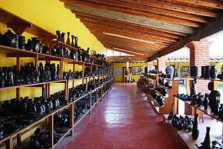
San Bartolo Coyotepec is a town and municipality located in the center of the Mexican state of Oaxaca. It is in the Centro District of the Valles Centrales region about fifteen km south of the capital of Oaxaca.
San Juan Quiahije is a town and municipality in Oaxaca in south-western Mexico. It is part of the Juquila District in the centre of the Costa Region. The origen of Quiahije is not known, some people conjecture it might mean "Stone Forest" in the Zapotec language.
San Miguel Panixtlahuaca is a town and municipality in Oaxaca in south-western Mexico. It is part of the Juquila District in the center of the Costa Region. The name "Panixtlahuatl" in the Nahuatl language means "Plain of the Bridge".
Villa Sola de Vega is a town and municipality in Oaxaca in south-western Mexico, part of the Sola de Vega District in the Sierra Sur Region. Significado "Lugar de codornices" proviene de "zollin": codorniz y de "tlán": lugar de.
Teotitlán del Valle is a small village and municipality located in the Tlacolula District in the east of the Valles Centrales Region, 31 km from the city of Oaxaca in the foothills of the Sierra Juárez mountains. It is part of the Tlacolula Valley district. It is known for its textiles, especially rugs, which are woven on hand-operated looms, from wool obtained from local sheep and dyed mainly with local, natural dyes. They combine historical Zapotec designs with contemporary designs such as reproductions of famous artists' work. Artists take commissions and participate in tours of family-owned workshops. The name Teotitlán comes from Nahuatl and means "land of the gods." Its Zapotec name is Xaguixe, which means "at the foot of the mountain." Established in 1465, it was one of the first villages founded by Zapotec peoples in this area and retains its Zapotec culture and language.
Santa Cruz Zenzontepec is a town and municipality in Oaxaca in south-western Mexico. It is part of the Sola de Vega District in the Sierra Sur Region.

The Costa Region or Costa Chica lies on the Pacific coast of the state of Oaxaca, Mexico, south of the more mountainous Sierra Sur inland from the coast. It includes the districts of Jamiltepec, Juquila and Pochutla.
Juquila District is located in the center of the Costa Region of the State of Oaxaca, Mexico, on the Pacific coast. It has an area of 5,055 km2. As of 2005 it had a total population of 134,365 of whom 33,106 spoke an indigenous language. Economic activities include agriculture and tourism. The Santuario (Sanctuary) de Juquila is a major attraction.

The Indigenous people of Oaxaca are descendants of the inhabitants of what is now the state of Oaxaca, Mexico who were present before the Spanish invasion. Several cultures flourished in the ancient region of Oaxaca from as far back as 2000 BC, of whom the Zapotecs and Mixtecs were perhaps the most advanced, with complex social organization and sophisticated arts.

The state of Oaxaca, Mexico has a total population of about 3.5 million, with women outnumbering men by 150,000 and about 60% of the population under the age of 30. It is ranked tenth in population in the country. Fifty three percent of the population lives in rural areas. Most of the state’s population growth took place between 1980 and 1990. Life expectancy is 71.7 for men and 77.4 for women, just under the national average. Births far outpace deaths. In 2007, there were 122,579 births and 19,439 deaths. Approximately 85% profess the Catholic faith.
According to the Mexican government agency Conapo, Oaxaca is the third most economically marginalized states in Mexico. The state has 3.3% of the population but produces only 1.5% of the GNP. The main reason for this is the lack of infrastructure and education, especially in the interior of the state outside of the capital. Eighty percent of the state's municipalities do not meet federal minimums for housing and education. Most development projects are planned for the capital and the surrounding area. Little has been planned for the very rural areas and the state lacks the resources to implement them. The largest sector of Oaxaca's economy is agriculture, mostly done communally in ejidos or similar arrangements. About 31% of the population is employed in agriculture, about 50% in commerce and services and 22% in industry. The commerce sector dominates the gross domestic product at 65.4%, followed by industry/mining at 18.9% and agriculture at 15.7%.