Amathus or Amathous was an ancient city and one of the ancient royal cities of Cyprus until about 300 BC. Some of its impressive remains can be seen today on the southern coast in front of Agios Tychonas, about 24 miles west of Larnaca and 6 miles east of Limassol. Its ancient cult sanctuary of Aphrodite was the second most important in Cyprus, her homeland, after Paphos.

Nicosia is the largest city, capital, and seat of government of the island of Cyprus. It is located near the centre of the Mesaoria plain, on the banks of the River Pedieos.
The Prehistoric Period is the oldest part of Cypriot history. On Cyprus, the earliest traces of human presence and of contacts with the mainland date to ca. 10500-10000 BC, or perhaps even earlier, as some evidence suggests. Hunter-gatherers, whose chipped stone industry may be roughly compared to Levantine Epipalaeolithic traditions, visited the island periodically, obtaining their food by collecting shellfish and the hunting of birds and reptiles. Wild boar was also hunted; as this species is absent from Pleistocene paleontological assemblages on the island, it is possible that it was introduced to Cyprus, a fact suggesting that these people were already masters of the art of navigation. The role of humans in the extinction of the endemic Pleistocene species, such as pygmy hippos and elephants, is much debated. Traces of such short, seasonal visits are known from Aetokremnos, a collapsed rock shelter located at the tip of the Akrotiri Peninsula, and in small open-air sites at Aspros, on the western coastline of Akamas Peninsula and Ayia Napa- Nissi Beach in the south-east of the island.

Luigi Palma di Cesnola, an Italian-American soldier, diplomat and amateur archaeologist, was born in Rivarolo Canavese, near Turin. He received the Medal of Honor for his actions during the American Civil War. He was United States consul at Larnaca in Cyprus (1865–1877) and first Director of the Metropolitan Museum of Art in New York (1879–1904).

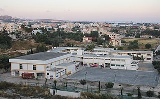
Kissonerga is a village in South West Cyprus, about 8 km north of Paphos, in a region notable for the cultivation of banana plantations, an area known as the Ktima Lowlands. In 1980 the population of the village was 700 people.

Kouklia is a village in the Paphos District, about 16 kilometres (9.9 mi) from the city of Paphos on the Mediterranean island of Cyprus. The village is built in the area of "Palaepaphos", mythical birthplace of Aphrodite, Greek goddess of love and beauty, which became the centre for her worship in the ancient world.

Tamassos or Tamasos – names Latinized as Tamassus or Tamasus – was a city-kingdom in Cyprus. It was situated in the great central plain of the island, south-east of Soli, on the road from Soli to Tremithus. It is an archaeological site bordering the village of Politiko, about 21 kilometres southwest of Nicosia.

Lempa is a village in Cyprus located approximately 4 km (2.5 mi) north of the town of Paphos. It is sometimes written as Lemba, which is also closer to the correct pronunciation. Neighboring villages are Empa, Kissonerga and Chlorakas.
Geroskipou is a coastal town in Cyprus, east of Paphos. Its current population is approximately 7,000 and it is the second largest municipality in the Paphos District. Yeroskipou, with its remarkable five-domed Byzantine church of Agia Paraskevi, and its Folk Art Museum, is a popular tourist destination. It is known especially for the production of Turkish Delight or "lokum". The town is the only place in the world which has protected geographical indication (PGI) for the popular dessert.
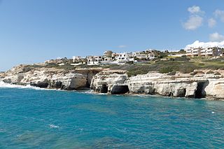
Pegeia is a town in the Paphos District of Cyprus. Pegeia is situated mainly on the steep slopes of the coastal hills inland from Coral Bay, at the southern end of the Akamas Peninsula, and it lies 14 km north of Paphos. It has a large population of British ex-pats and a growing number of holiday homes and apartments. In the town centre can be found a town hall, church, police station and several small shops, restaurants and banks. Due to its hillside location many parts of the town offer views over Coral Bay and Paphos.
Stroumpi or Stroumbi is a small village in central Paphos District, Cyprus, and halfway between Paphos and Polis. The name of the village is said to derive from its founder, a man called "Stroumpos", or the shape of the surrounding hills. The village is known for its annual "Dionysia" wine festival named after Dionysos, the ancient Greek god of wine, that takes place at the end of August. A now-defunct "Dionysos" volleyball team was based in Stroumpi and played in the Cypriot top league.
Peter M. Fischer is an Austrian-Swedish archaeologist. He is a specialist on Eastern Mediterranean and Near Eastern archaeology, and archaeometry. He belongs to the University of Gothenburg and is associated with the Austrian Academy of Sciences, Sweden. He is the founder and director of the Swedish Jordan Expedition, the Palestinian-Swedish Expedition at Tall al-Ajjul, Gaza. He became the director of the Swedish Cyprus Expedition in 2009 and carried out excavations at Hala Sultan Tekke since 2010. He is member/corresponding member of The Royal Society of Arts and Sciences in Gothenburg, Royal Swedish Academy of Letters, History and Antiquities. and The Austrian Academy of Sciences.
Paphos Archaeological Museum is a museum in Paphos, western Cyprus. It contains items ranging in age from the Neolithic to 1700 AD, with five rooms showcasing exhibits dating from the Neolithic era to the Middle Ages. Most of the artefacts were unearthed in Palepafos (Kouklia), Nea Pafos (Paphos) and Marion-Arsinoe (Polis), and also from Pegeia, Kisonerga, Lempa, Pano Arodes, Salamiou, Akourdalia, Pomos, Kidasi, Geroskipou and other places. The collection includes skeletal remains recovered from 31 tombs near the eastern seafront of the ancient city of Nea Pafos in 1980-3.

Ayios Andreas or Tophane is a Neighbourhood, Quarter, Mahalla or Parish of Nicosia, Cyprus. In September 1945, the Ottoman name of Tophane was changed to Ayios Andreas, but there is no parish church of that name.
Sophocles Sophocleous was born and educated in Lefkosia. He then studied at the University of Human Sciences of Strasbourg and Paris-X-Nanterre and at ICCROM in Rome.

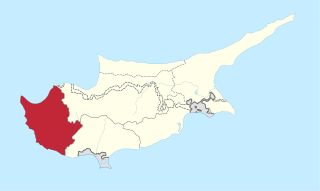
Limassol District or Lemesos is one of the six districts of Cyprus. As of 2011, it had a population of 239.842, 77% of which was urban. Its main city is Limassol. Part of the British Overseas Territory of Akrotiri and Dhekelia forms an enclave on the Akrotiri Peninsula, under the sovereignty of the United Kingdom.
Jennifer M. Webb is an archaeologist who was born in 1953, in Melbourne, Australia. She currently holds a position as a Charles La Troube Research Fellow at La Trobe University, a position she took in 2008.Recent research includes a volume covering documentation of tombs at Lapithos that had been excavated in the early 1900s, for which she was awarded a grant from the White Levy program.