The United Nations Buffer Zone in Cyprus is a demilitarized zone, patrolled by the United Nations Peacekeeping Force in Cyprus (UNFICYP), that was established in 1964 and extended in 1974 after the cease fire of 16 August 1974, following the Turkish invasion of Cyprus, and the de facto partition of the island into the area controlled by the Republic of Cyprus and the Turkish Republic of Northern Cyprus in the North. The zone, also known as the Green Line, stretches for 180 kilometres from Paralimni in the east to Kato Pyrgos in the west, where a separate section surrounds Kokkina. The zone cuts through the centre of Nicosia, separating the city into southern and northern sections. In total, it spans an area of 346 square kilometres (134 sq mi), varying in width from less than 20 metres (66 ft) to more than 7 kilometres (4.3 mi).

Tymbou or Tymbu is a village in the central Mesaoria plain of Cyprus. Tymbou is under the de facto control of Northern Cyprus. After 1960, the village was inhabited exclusively by Greek Cypriots; in 1973, they numbered 1,288. The original population fled the village in 1974, following the Turkish Invasion of Cyprus. As of 2011, Tymbou had a population of 384.

Kormakitis is a small village in Cyprus. It is under the de facto control of Northern Cyprus. Kormakitis is one of four traditionally Maronite villages in Cyprus, the other three being Asomatos, Agia Marina and Karpaseia. The Maronites of Kormakitis traditionally speak their own variety of Arabic called Cypriot Maronite Arabic (CMA) in addition to Greek and recently Turkish. Cape Kormakitis is named after the village.
Lempa is a village in Cyprus located approximately 4 km (2.5 mi) north of the town of Paphos. It is sometimes written as Lemba, which is also closer to the correct pronunciation. Neighboring villages are Empa, Kissonerga and Chlorakas.
Achna is an abandoned village in the Famagusta District of Cyprus. It is just north of the Buffer Zone and it is under the de facto control of Northern Cyprus. After the 1974 Turkish invasion, its displaced inhabitants built a new village nearby.

Petrofani is an abandoned village in central Cyprus. It is located in the Larnaca District and is about 2.5 kilometers southwest of Athienou. Petrofani is close to the United Nations Buffer Zone in Cyprus. Prior to the 1974 Turkish invasion of Cyprus, the village was inhabited by Turkish Cypriots.

Peristerona is a large village about 32 kilometres west of the capital Nicosia, on the foothills of the Troodos Mountain range in the Morphou basin. It is built on the west bank of the river that bears the same name, which is a tributary of the river Serrachis, at an average altitude of 250 meters.

Evrychou is a village in Cyprus. It is located in the Nicosia District and the agricultural centre of the "Solea" region located about 50 km south-west of Nicosia and 30 km from mount Troodos.
Kofinou is a village located in the Larnaca District of Cyprus. It is situated where the roads from Nicosia, Larnaca and Limassol trisected, prior to the by-pass built in the 1990s.

Akanthou is a village in Famagusta District, on the northern coast of Cyprus. Akanthou is under the de facto control of Northern Cyprus. As of 2011, it had a population of 1,459.
Skylloura is a village located in the Nicosia District of Cyprus, about halfway between the towns of Morphou and Nicosia. It is administered by the Lefkoşa District of Northern Cyprus. In the town the two main roads Morphou-Nicosia and Kyrenia-Lapithos-Skylloura meet.
Diorios or Dhiorios is a village in the Kyrenia District of Cyprus, 2 km west of Myrtou. It is under the de facto control of Northern Cyprus.
Angolemi is a village in the Nicosia District of Cyprus, southwest of Morphou. De facto, it is administered as part of the Lefke District of Northern Cyprus.
Aplanta is an abandoned village in the Larnaca District of Cyprus, located 4 km south of Anglisides. Aplanta was inhabited exclusively by Turkish Cypriots; in 1960, they numbered 55. Due to the Cyprus crisis of 1963–64 they fled to Kivisili in December 1963. After the 1974 Turkish invasion and subsequent partition of the island, most moved to Limnia.

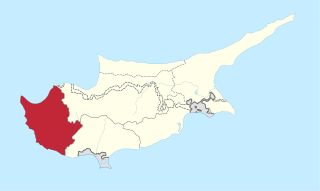
Paramali is a village on the south coast of the island of Cyprus, in the Limassol District 4 kilometres (2.5 mi) east of Avdimou. Its district covers an area stretching north from the south coast of Cyprus, with roughly equal parts falling in the British Overseas Territory of Akrotiri and Dhekelia to the south, and in the Republic of Cyprus to the north.
Vretsia is an abandoned Turkish Cypriot village in the Paphos District of Cyprus, located 4 kilometres (2.5 mi) east of Koilineia. After the 1974 war, the Turkish-Cypriot natives of the village were forced to abandon the village and emigrate to the north of Cyprus.
Androlykou is a Turkish Cypriot village in the Paphos District of Cyprus, located 5 km southwest of Polis Chrysochous.
Melandra is an abandoned Turkish Cypriot village in the Paphos District of Cyprus, located 2 kilometres (1.2 mi) southeast of Lysos. Prior to 1974, the village was inhabited by Turkish Cypriots. The village is completely destroyed, apparently by shelling. The only two buildings that were not touched are the mosque and the orthodox chapel.
Bloody Christmas is a term used mainly, but not exclusively, in Turkish Cypriot and Turkish historiography, referring to the outbreak of intercommunal violence between the Greek Cypriots and the Turkish Cypriots during the Cyprus crisis of 1963–64, on the night between 20–21 December 1963 and the subsequent period of island-wide violence amounting to civil war. The violence led to the deaths of 364 Turkish Cypriots and 174 Greek Cypriots. 25,000 Turkish Cypriots from 104 villages, amounting to a quarter of the Turkish Cypriot population, fled their villages and were displaced into enclaves. Thousands of Turkish Cypriot houses left behind were ransacked or completely destroyed. 1,200 Armenian Cypriots and 500 Greek Cypriots were also displaced. The violence precipitated the end of Turkish Cypriot representation in the Republic of Cyprus.
Goşşi or Goshi is an abandoned village in the Larnaca District of Cyprus, about 15 km north-west of Larnaca. It was originally inhabited exclusively by Turkish Cypriots. Nearly all of them were displaced during the 1974 Turkish invasion; most resettled in Exometochi. In 1973, Goşşi had an estimated population of 244. It is now the location of a Greek-Cypriot army camp.