The United Nations Buffer Zone in Cyprus is a demilitarized zone, patrolled by the United Nations Peacekeeping Force in Cyprus (UNFICYP), that was established on 4 March 1964. It was extended on 9 August after the Battle of Tillyria and extended again in 1974 after the ceasefire of 16 August 1974, following the Turkish invasion of Cyprus and the de facto partition of the island into the area controlled by the Republic of Cyprus and the largely unrecognized Turkish Republic of Northern Cyprus in the north. The zone, also known as the Green Line, stretches for 180 kilometres from Paralimni in the east to Kato Pyrgos in the west, where a separate section surrounds Kokkina.

Rizokarpaso is a town on the Karpas Peninsula in the Northeastern part of Cyprus. While nominally part of the Famagusta District of the Republic of Cyprus, it has been under the de facto control of Northern Cyprus since the Turkish invasion of the island in 1974, being administered as part of the İskele District.

The United Nations Peacekeeping Force in Cyprus (UNFICYP) is a United Nations Peacekeeping Force that was established under United Nations Security Council Resolution 186 in 1964 to prevent a recurrence of fighting following intercommunal violence between the Greek Cypriots and Turkish Cypriots, to contribute to the maintenance and restoration of law and order and to facilitate a return to normal conditions. Major General Erdenebat Batsuuri (Mongolia) is the current Force Commander of UNFICYP, appointed in 2024, and preceded by Ingrid Gjerde (Norway).
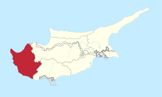
The Paphos District, or simply Paphos, is one of the six districts of Cyprus and it is situated in the western part of Cyprus. Its main town and capital is Paphos. The entire district is controlled by the internationally recognised government of Cyprus. There are four municipalities in Paphos District: Paphos, Yeroskipou, Peyia, and Polis Chrysochous.

Peristerona is a large village about 32 kilometres west of the capital Nicosia, on the foothills of the Troodos Mountain range in the Morphou basin. It is built on the west bank of the river that bears the same name, which is a tributary of the river Serrachis, at an average altitude of 250 meters.
Fyti is a village in the Paphos District of Cyprus. It is situated on a plateau 25 km north-east of Paphos and 20 km south-east of Polis. There are several small villages within a 3 km radius of Fyti, including Lasa, Kritou Marottou and Anadiou, all residing at an average altitude of 680 m.
Pyrogi is a village in the Nicosia District of Cyprus, located south of Tymbou. It is under de facto control of Northern Cyprus. Today it is largely uninhabited, as the village lies within military area and can only be visited with permission of the Turkish military. In 1960 the village had 460 inhabitants. One kilometre northwest of the town lies the also uninhabited former village of Margo.
Armenochori is an Armenian village located in the Limassol District of Cyprus, 10 kilometres northeast of the city of Limassol. Armenochori means “Armenian village” in Greek. In 1958, the Turkish Cypriots adopted the alternative name Esenköy, literally meaning “windy village.”
Kourou Monastiri is a Turkish Cypriot village in the Nicosia District of Cyprus, located 8 kilometres (5.0 mi) east of Kythrea. Kourou Monastiri is under the de facto control of Northern Cyprus. As of 2011, it had a population of 208.
Vouno is a village in the Kyrenia District of Cyprus. De facto, it is under the control of Northern Cyprus. Its population in 2011 was 299.
Makrasyka is a village in the Famagusta District of Cyprus, located 3 kilometres (1.9 mi) west of Achna. It is under the de facto control of Northern Cyprus.
Agios Chariton is a small village in Cyprus. It is located 10 kilometres (6.2 mi) north of Marathovounos, on the south side of the Kyrenia mountain range. Agios Chariton is under the de facto control of Northern Cyprus. As of 2011, it had a population of 96. It has historically been a Turkish Cypriot village.
Trypimeni is a small village in the Famagusta District of Cyprus, located 12 kilometres (7.5 mi) north of Marathovounos on the south side of the Kyrenia mountain range. It is under the de facto control of Northern Cyprus.
Agios Iakovos is a village in Cyprus, located 9 kilometres (5.6 mi) northwest of Trikomo. It is under the de facto control of Northern Cyprus. As of 2011, Agios Iakovos had a population of 229 inhabitants. It has historically been inhabited by Turkish Cypriots.
Agios Ilias is a village in the Famagusta District of Cyprus, located 6 kilometres (3.7 mi) north-east of Trikomo. It is under the de facto control of Northern Cyprus.

Komi Kebir is a village under the de facto control of Northern Cyprus, claimed by Cyprus. It is located on the Karpas Peninsula, 33 kilometres (21 mi) north of Famagusta, and at an altitude of 90 metres. As of 2011, it had a population of 812.

Koilani is a village in the Limassol District of Cyprus, located 3 kilometres (1.9 mi) south of Pera Pedi.
Vretsia is an abandoned Turkish Cypriot village in the Paphos District of Cyprus, located 4 kilometres (2.5 mi) east of Koilineia. After the 1974 Turkish invasion of Cyprus, Turkish-Cypriot natives of the village abandoned their properties and moved to the north of Cyprus.
Melandra is an abandoned Turkish Cypriot village in the Paphos District of Cyprus, located 2 kilometres (1.2 mi) southeast of Lysos. Prior to 1974, the village was inhabited by Turkish Cypriots. The village is destroyed, apparently by shelling.